RUSSIAN JOURNAL OF EARTH SCIENCES, VOL. 19, ES1004, doi:10.2205/2018ES000652, 2019
E. V. Artyushkov1, P. A. Chekhovich1,2
1Schmidt Institute of Physics of the Earth of the RAS, Moscow, Russia
2Lomonosov Moscow State University, Earth Science Museum, Moscow, Russia
The deep-water basin on the Lomonosov Ridge in Central Arctic was rapidly formed on a shallow water shelf in the early Miocene. The continuity of the main seismic reflectors in the sedimentary cover of the ridge indicates no significant crustal stretching during the subsidence. The absence of large free-air gravity anomalies above the ridge precludes the dynamic topography in the mantle from being a cause of the formation of the basin. In the Miocene, the ridge was very far from the convergent boundaries therefore lithospheric flexing is unlikely to produce the subsidence. Under these conditions, crustal subsidence on the ridge was most probably associated with the increase in the crustal density due to metamorphic reactions catalyzed by fluid infiltration from the mantle.
|
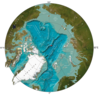
| Figure 1 |
The Central Arctic (Figure 1) is characterized by deep water conditions. The Eurasian Basin is underlain by the oceanic crust. It was formed by sea-floor spreading on the Gakkel Ridge during the last 53 Myr. The nature of the crust in the 1–4-km-deep Amerasian Basin is debatable. Most researchers relate it to the oceanic type, probably modified by magmatic intrusions and underplating [D{ssing et al., 2017; Grantz et al., 2011; Lawver et al., 2002 and many others]. However, band magnetic anomalies formed by sea-floor spreading are absent in this region. Hence, it is believed that the oceanic crust was formed during the Cretaceous Normal Superchron 83–125 million years ago [Olson and Amit, 2015] when the Earth's magnetic field had normal polarity.
Deep seismic refraction profiling shows that a 1-5-km-thick layer with P-wave velocities typical of the granitic layer of the continental crust exists in the upper crust of the Amerasian Basin [Kashubin et al., 2013]. Based on these data many Russian authors believe that the basin is underlain by the continental crust (see [Piskarev et al., 2016] for review). In this case, the question arises, what could have caused a strong crustal subsidence with the formation of deep-water basins on the continental crust which was initially above sea level or close to it. The lack of direct data regarding the history of crustal subsidence in the Amerasian Basin is the main problem.
 |
| Figure 2 |
Deep-sea drilling in the Central Arctic was carried out only in the axial part of the Lomonosov Ridge close to the North Pole (Figure 2). The water depth in this region is about 1000 m [Backman et al., 2006; Moran et al., 2006]. Four holes were drilled (Figure 2), which allowed the compilation of a composite 428-m-long geological section. A regional seismic unconformity (shown in yellow) separates the Cenozoic sedimentary cover from the underlying Cretaceous continental crust.
 |
| Figure 3 |
The drilling data obtained on the Lomonosov Ridge allow us to reconstruct the history of crustal movements on the ridge during the Cenozoic and latest Cretaceous. The part of the composite section with the thickness about 200 m includes the Paleocene and lower Eocene sediments which were deposited in the brackish-water estuarine environment (Figure 3). The middle Eocene and Oligocene sediments are absent which produces a 26-Myr long non-depositional hiatus and regional unconformity (RU) in the seismic section [Poselov et al., 2014]. This non-deposition epoch ended in the early Miocene 18.2 Myr ago. The hiatuses with the absence of sediments alternating with the episodes of shallow-water deposition also occur in the lower part of the composite section [Backman et al., 2008]. There are a few meters of Upper Cretaceous terrestrial deposits at the base of the composite sedimentary section. These deposits are of the late Campanian or probably Maastrichtian age. About 72.5 Myr ago, the so-called Post-Campanian unconformity (pCU) was formed at their top. These data indicate that the crust surface of the Lomonosov Ridge remained close to sea level for at least 54 Myr.
 |
| Figure 4 |
A drastic change in the deposition on the ridge occurred in the early Miocene 18.2 Myr ago. Regional unconformity RU was overlain by the pelagic sediments whose deposition has continued up to present (Figure 3). This suggests rapid subsidence of the crust with the formation of a deep-water basin. As follows from the seismic reflection data, the subsidence occurred all across the ridge (see, e.g., Figure 4). Its magnitude is about 1 km on the ridge axis and up to 2–2.5 km on the ridge's margins.
A number of deep sedimentary basins exist on the continents and on their margins. Many basins contain large volumes of hydrocarbons, which makes the problem of basin formation very important. Several mechanisms have been proposed to explain the subsidence of the continental crust. Among these mechanisms, vertical displacements of the lithosphere driven by the convective flows in the underlying mantle (dynamic topography) are very popular [Flament et al., 2013; Lithgow-Bertelloni and Silver, 1998]. As noted above, the magnitude of the crustal subsidence on the Lomonosov Ridge is about 1 km in its axial part and reaches 2–2.5 km on the ridge's margins. Such a subsidence due to the dynamic topography should produce intense negative free-air anomalies over the ridge. However, in reality, the positive free-air anomalies with an amplitude of a few tens of milligals exist over the ridge (Figure 3.1.2 in [Piskarev et al., 2016]). Another mechanism is a lithospheric flexure under the loading of a large nappe or under a pull of the subducted plate attached to the edge of the plate that remains on the surface [Allen and Allen, 2013; Watts, 2001]. In the Neogene, there were no convergent boundaries close to the Lomonosov Ridge, which rules out the possibility that crustal subsidence was this mechanism.
Crustal thinning due to lateral extension with the related isostatic subsidence was initially proposed for the Baikal Graben [Artemjev and Artyushkov, 1968, 1971]. It was assumed that viscous deformations develop in the lower, heated, part of the crust whereas the upper crust becomes split into blocks by large normal faults. Various possible modes of extension of the lithospheric layer were suggested later (e.g., [McKenzie, 1978; Wernicke, 1985]). In the pure shear model, the intensity of stretching $\beta$ can be determined from the depth $h_w$ of the water-loaded basin formed after the complete cooling of the crust and mantle in the lithospheric layer. In the case of local isostasy,
\begin{equation} \tag*{(1)} \beta = \{1 - [(\rho_m - \rho_w)/(\rho_m - \rho_c)](h_w/h_c^0)\}^{-1} \end{equation}Here, $\rho_m = 3.33$ g/cm$^3$ is mantle density, $\rho_w = 1.03$ g/cm$^3$ is water density, $\rho_c = 2.84$ g/cm$^3$ is crustal density, and $h_c^0 = 40$ km is the initial thickness of the continental crust. Assuming in formula (1) $h_w = 1-2$ km for the water depth in the basin that was formed in the early Miocene, we obtain
\begin{equation} \tag*{(2)} \beta = 1.12 - 1.23 \end{equation}The subsidence began 18.2 Myr ago. During that time, a new temperature distribution could not have been established in the crust and underlying mantle. Therefore, formula (2) gives the minimum stretching intensity which would be necessary to produce the observed subsidence.
 |
| Figure 5 |
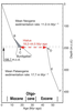
Rifted terrains with considerable lithospheric stretching are quite numerous (see, e.g., [Artyushkov, 1993; Ziegler, 1992]). In particular, they are widespread in the North Sea, East Africa, and Eastern China. These regions are characterized by intense deformations of the basement with normal faulting and splitting of the upper crust into a set of the large blocks (Figure 5). The blocks become tilted to cover the stretched lower crust. The tilt angle $\theta$ increases with the intensity of stretching $\beta$ as [Artyushkov, 1993]:
\begin{eqnarray*} \theta = \alpha - \arcsin[(\sin\alpha) /\beta] \end{eqnarray*}Here, $\alpha$ is the initial dip angle of the normal faults. With a typical $\alpha$ value of $\sim 25\mbox{°}$ and $\beta= 1.23$ (which corresponds to $h_w = 2$ km)
\begin{eqnarray*} \theta = 5[degree] \end{eqnarray*}The blocks with these tilt angles can be easily noticed in the Cenozoic deposits in the high-quality seismic reflection profiles across the Lomonosov Ridge. However, no tilted blocks are observed in the profiles. For example, in the profile shown in Figure 2, at the ACEX drilling site, all the beds in the Cretaceous sedimentary cover are continuous. Similarly, in the profile in Figure 4, the continuity can be traced along the reflector D$_1$ corresponding to the Regional unconformity as well as along the reflector A which is the base of the Eocene units. These data indicate that the deep-water basin on the Lomonosov Ridge could not be produced by lithospheric stretching.
In the absence of significant stretching and large isostatic anomalies over the Lomonosov Ridge, the formation of a deep-water basin in the early Miocene can only be explained by the increase in the rock density in the crustal layer. This mechanism was previously proposed for explaining the formation of the ultradeep basins in the Barents Sea, North Caspian and South Caspian regions [Artemieva and Thybo, 2013; Artyushkov et al., 2014; Gac et al., 2012]
Under the conditions of local isostasy the formation of a water-loaded basin with depth $h_w$ requires that gabbro with density $\rho_{\mathrm{gb}}$ would pass into eclogite with density $\rho_e$ in the gabbro layer with thickness
\begin{eqnarray*} h_{\mathrm{gb}} = (\rho_e / \rho_m) [(\rho_m - \rho_w)/(\rho_e - \rho_{\mathrm{gb}})]h_w \end{eqnarray*}Assuming $\rho_e = 3.4$ g/cm$^3$, $\rho_{\mathrm{gb}} = 2.9$ g/cm$^3$, and $h_w = 1-2$ km with the other parameter values indicated above, we find
\begin{eqnarray*} h_{\mathrm{gb}} = 4.7 - 9.4 \; \mathrm{km} \end{eqnarray*} |
| Figure 6 |
Seismic refraction soundings in the southern part of the Lomonosov Ridge with the water depth indicated above show that the Moho depth is by 6–7 km smaller beneath the ridge than beneath the adjacent shelf (Figure 6) [Poselov et al., 2014]. It is most probable that this boundary is underlain by eclogites which are denser than mantle peridotites. However, eclogites are characterized by P-wave velocities typical of mantle peridotites and, according to the seismic data, these rocks are commonly placed below the Moho. Thus, it is quite probable that the Moho beneath the Lomonosov Ridge is underlain by dense mafic eclogites which actually pertain to the crust as suggested by their mineralogical composition.
In the presence of fluids, the rate of metamorphic reactions increases by orders of magnitude [Austrheim, 1987; Jamtveit and Austrheim, 2010]. Hence, rapid transformation of gabbro into eclogites in the lowermost crust of the Lomonosov Ridge in the early Miocene can be hypothetically thought of as the result of metamorphism under infiltration of fluids from the mantle.
Rapid crustal subsidence with the formation of deep-water basins is a typical feature of the large hydrocarbon basins such as the North Caspian and West Siberian basins and many others [Artyushkov, 1993]. Therefore, it is quite probable that the Lomonosov Ridge pertains to the same basin type.
As follows from the data presented above, rapid formation of a deep-water basin on the Lomonosov Ridge occurred without significant stretching of the lithospheric layer. In the absence of the large free-air gravity anomalies above the ridge, the subsidence required a considerable increase in the density of the rocks within the crust due to the metamorphic reactions. Strong acceleration of metamorphism was possible under the infiltration of fluids from the mantle. Similar episodes of rapid crustal subsidence with the formation of deep-water basins took place in many sedimentary basins [Artyushkov, 1993; Artyushkov et al., 2014]. It is probable that several other deep-water basins located to the east of the Lomonosov Ridge in the Central Arctic, the Makarov and Podvodnikov basins, as well as the deeply submerged Mendeleev High were also formed by this mechanism.
Allen, P. A., J. R. Allen (2013), Basin Analysis: Principles and Application to Petroleum Play Asessment, 3rd Edition, 619 pp., Wiley-Blackwell, Oxford.
Artemjev, M. E., E. V. Artyushkov (1968), On the origin of rift valleys, Proceedings of the Russian Academy of Sciences, Ser. Geology, no. 4, p. 58–73 (in Russian).
Artemjev, M. E., E. V. Artyushkov (1971), Structure and isostasy of the Baikal rift and the mechanism of rifting, J. Geophys. Res., 76, no. 5, p. 1197–1211, https://doi.org/10.1029/JB076i005p01197.
Artemieva, I. M., H. Thybo (2013), Moho depth and crustal structure in Europe, Greenland, and the North Atlantic region, Geophysical Research Abstracts, 15, p. EGU2013-1791 (http://meetingorganizer.copernicus.org/EGU2013/EGU2013-1791.pdf).
Artyushkov, E. V. (1993), Physical Tectonics, 456 pp., Nauka, Moscow (in Russian).
Artyushkov, E. V., I. V. Belyaev, G. S. Kazanin, S. P. Pavlov, P. A. Chekhovich, S. I. Shkarubo (2014), Formation mechanisms of ultradeep sedimentary basins: the North Barents basin. Petroleum potential implications, Russ. Geol. Geophys., 55, p. 649–667, https://doi.org/10.1016/j.rgg.2014.05.009.
Austrheim, H. (1987), Eclogitization of lower crustal granulites by fluid migration through shear zones, Earth Planet. Sci. Lett., 81, p. 221–232, https://doi.org/10.1016/0012-821X(87)90158-0.
Backman, J., et al. (2006), Sites V0001-M0004, Proceedings of the Integrated Ocean Drilling Program, 302, p. 169.
Backman, J., M. Jakobsson, V. Frank, et al. (2008), Age model and core-seismic integration for the Cenozoic Arctic Coring Expedition sediments from the Lomonosov Ridge, Paleoceanography, 23, p. PA1S03, https://doi.org/10.1029/2007PA001476.
Døossing, A., C. Gaina, J. M. Brozena (2017), Building and breaking a large igneous province: An example from the High Arctic, Geophys. Res. Lett., 44, https://doi.org/10.1002/2016GL072420.
Flament, N., M. Gurnis, R. D. Müller (2013), A review of observations and models of dynamic topography, Lithosphere, 5, no. 2, p. 189–210, https://doi.org/10.1130/L245.1.
Gac, S., R. S. Huismans, Yu. Yu. Podladchikov, J. Y. Faleide (2012), On the origin of the ultradeep East Barents Sea basin, J. Geophys. Res., 117, p. B04401, https://doi.org/10.1029/2011JB008533.
Grantz, A., P. Hart, V. Childers (2011), Geology and tectonic development of the Amerasia and Canada Basins, Arctic Ocean, Arctic Petroleum Geology. Geological Society (London) Memoirs, Spencer, A. M., Embry, A. F., Gautier, D. L., Stoupakova, A. V., Sørensen, K. (eds.), vol. 35, p. 771–799, Geological Society, London.
Jakobsson, M., J. Backman, B. Rudels, J. Nycander, et al. (2007), The early Miocene onset of a ventilated circulation regime in the Arctic Ocean, Nature, 447, p. 986–990, https://doi.org/10.1038/nature05924.
Jamtveit, B., H. Austrheim (2010), Metamorphism: The Role of Fluids, Elements, 6, p. 153–158, https://doi.org/10.2113/gselements.6.3.153.
Jokat, W. (2005), The sedimentary structure of the Lomonosov Ridge between 88° N and 80° N, Geophysical Journal International, 163, p. 698–726, https://doi.org/10.1111/J.1365-246X.2005.02786.x.
Kashubin, S. N., N. I. Pavlenkova, O. V. Petrov, Ye. D. Milstein, S. P. Shokalsky, M. Erinchek (2013), Types of the Earth's crust of the Circumpolar Arctic, Regional geology and metallogeny, 55, p. 5–20 (in Russian).
Lawver, L. A., A. Grantz, L. M. Gahagan (2002), Plate kinematic evolution of the present Arctic region since the Ordovician, Spec. Pap. Geol. Soc. Am., 360, p. 333–358, https://doi.org/10.1130/0-8137-2360-4.333.
Lithgow-Bertelloni, C., P. G. Silver (1998), Dynamic topography, plate driving forces and the African superswell, Nature, 395, p. 269–272, https://doi.org/10.1038/26212.
McKenzie, D. (1978), Some remarks on the development of sedimentary basins, Earth and Planet. Sci. Lett., 40, p. 25–32.
Moran, K., J. Backman, Y. Brinkhuis, et al. (2006), The Cenozoic paleoenvironment of the Arctic Ocean, Nature, 444, p. 601–606, https://doi.org/10.1038/nature04800.
Olson, P., H. Amit (2015), Mantle superplumes induce geomagnetic superchrons, Front. Earth Sci., 3, p. 38, https://doi.org/10.3389/feart.2015.00038.
Pinet, B., L. Montadert, A. Mascle, et al. (1987), New insights on the structure and formation of sedimentary basins from deep seismic profiling in Western Europe, Petroleum Geol. of North West Europe, p. 11–31, Graham and Trotman, London.
Piskarev, A. L., V. A. Poselov, G. P. Avetisov, et al. (2016), Arctic Basin (Geology and Morphology), V. D. Kaminsky (ed.), 291 pp., VNIIOkeanGeologiya, SPb (in Russian).
Poselov, V. F., V. V. Butsenko, A. A. Chernykh, Y. Y. Glebovsky, et al. (2014), The structural integrity of the Lomonosov Ridge with the North American and Siberian continental margins, 332 pp., VSEGEI, SPb.
Rekant, P. V., E. A. Gusev, V. A. Vinogradov (2012), Horst-graben structures of the Lomonosov Ridge sedimentary cover: history of formation and linkages with the Siberian shelf, Geophysical Institute Report UAG-R, p. 165–167, University of Alaska, Fairbanks, Alaska.
Watts, A. B. (2001), Isostasy and Flexure of the Lithosphere, 458 pp., Cambridge University Press, Cambridge.
Wernicke, B. (1985), Uniform-sense normal simple shear of the continental lithosphere, Canadian Journal of Earth Sciences, 22, no. 1, p. 108–125, https://doi.org/10.1139/e85-009.
Ziegler, P. A. (1992), North Sea rift system, Tectonophysics, 208, p. 55–75, https://doi.org/10.1016/0040-1951(92)90336-5.
Received 6 December 2018; accepted 18 December 2018; published 5 February 2019.

Citation: Artyushkov E. V., P. A. Chekhovich (2019), Geodynamics of the Lomonosov Ridge in the Central Arctic, Russ. J. Earth Sci., 19, ES1004, doi:10.2205/2018ES000652.
Copyright 2019 by the Geophysical Center RAS.