
|
|
| Figure 12 |

|
| Figure 13 |

|
| Figure 14 |
[25] (1) the volume of the firn material that collapsed onto the glacier: Vfirn = 22 million m3;
[26] (2) the volume of the ice, involved into the catastrophic motion of 20 September 2002 (including the avalanche material): Vice 1 = 137 million m3;

|
| Figure 15 |

|
| Figure 16 |
[29] (5) the volume of the ice left along the transit path as selvage and blocks lagging behind: Vice 3 = 22 million m3.
[30] The huge avalanche of the Kolka Glacier was recorded by many seismic stations of the Caucasus area. The most complete record (lasting about 16 min) was obtained by the Tsei seismic recording unit, located 44 km west of the catastrophe site. The detailed description of the seismic records, with the beginning and end of each seismograph operation, is provided in the paper of (A. A. Godzikovskaya, in press, 2004). The main result of this study was the discovery of the high variation of all record characteristics in time:
[31] 1. 1605:13.0 recording onset (Greenwich time: hour-min-sec).
[32] 2. 1605:13.0 - 1609:05.0 noise at the level of the seismograph sensitivity.
[33] 3. 1609:05.0 - 1610:21.0 interval of notable amplitude growth.
[34] 4. 1610:21.0 - 1615:30.0 interval of substantial amplitude growth.
[35] 5. 1615:30.0 - 1621:10.0 interval of notable amplitude reduction.
[36] 6. 1621:10.0 end of record.

|
| Figure 17 |
|
| Figure 18 |
[39] Taking into account the fact that the description of the process is based on the circumstantial facts, it should be treated as a hypothesis.
[40] Proceeding from the data available, it can be noted that:
[41] (1) the initial velocity of the active body was equal to zero;
[42] (2) no large shock, capable of communicating any significant (additional) acceleration to the glacier body of 137,000,000 tons was recorded by the seismographs;
[43] (3) the process of adding new rock material to the glacier rear because of avalanches continued more than two months. The photographs A and B in Figure 9 suggest that the avalanches from the firn fields produced a large and sufficiently thick alluvial fan on the surface of the Kolka Glacier as early as the end of August, 2002. Shear stresses in the glacier body continued to grow until reaching the critical values. The interval No. 2 in the seismic record obtained by the Tsei seismic recording unit (1605:13.0-1609:05.0) can be interpreted as the rapid development of faults in the active glacier body, which produced a large cleavage in the layer of the bottom ice (Figure 13) and, hence, the loss of stability. The amplitudes of seismic waves in this time interval are 10-40 times lower than in the interval No. 3.
[44] (4) The value of the seismic effect which stabilized after the date of 1609:05 was high enough to be recorded by the seismographs of the "Alpha-Geon" local network, including the "FIG" seismic station. This fact can be treated as the beginning of the gravitational active glacier body movement.

|
| Figure 19 |

|
| Figure 20 |
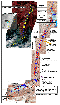
[46] The acceleration of the active body motion was recorded by the seismographs during the time of 1 min 16 sec (see interval No. 3 in the seismic record obtained by the Tsei seismic station). This time interval is sufficient for an active body to attain a velocity of 220-240 km hour -1 over a distance of about 2 km. At the time interval of 80-90 sec the avalanche front reached the Maili moraine and, having rebounded from it, began its gentle turn to the left at a fairly large angle (up to 50o). In this turn the avalanche flow over the right side rose to a height of 250 m above the thalweg (in the cross-section). The left flank of the avalanche, moving along the thalweg of the Kolka-Don River, left its trace along the left side of the canyon at the height of 30-40 m. This height difference, with same width of its trace (~700 m), can be explained by a significant centrifugal force produced by the high-velocity turn. The sesmographs recorded the first high interaction. This site is marked as point 1 in the topographic map. Shown in the frame of this drawing are several inserts which help to percieve and interpret this information. In the inserted diagram "The time distribution of the total energy vector", the point no. 1 is shown though not in the figure plan, but in the time scale. The arrival time of the "FIG" seismic signal is tied to the time scale of the "Tsei" seismic station and is marked as 1609:05 (Greenwich time). The numbers of the observation sites, shown in the topographic map, and those shown in the diagram correspond to one another. Farther on, the avalanche followed a relatively rectilinear trough with the width varying from 100 m to 150 m, the slopes consisting of loose deposits, varying in steepness from 30o to 40o. The bedrock outcrops have an "island" character and are located mainly at the right side of the valley. The area discussed has a length of 9.5 km, where the avalanche trace resembles the trace of a slalomist. The maximum height of these traces is 180 m, the minimal height being 10-20 m, with the arc length of each turn measuring not less than 1000 m. Of particular interest is Site no. 9 which corresponds to the absolute maximum of seismic energy produced by the moving glacier. Here the avalanche overflow was as high as 248 m.
[47] Table 1 shows the results of the computations used to plot the curve of the glacier avalanche speed along the Genaldon Canyon (Figure 19, b-2). The headings of the columns of the calculation table:
[48] 1. The name of the object or the number of the trajectory point
[49] 2. The distance between the neighbouring sites
[50] 3. The distance from Dzhimarai-Hoh Wall
[51] 4. Acceleration of an active body at the beginning of its motion
[52] 5. The time needed to cover the distance from the previous site
[53] 6. Time from the motion onset
[54] 7. Time from the seismogram
[55] 8. Calculted speed (m sec-1 )
[56] 9. Calculated speed (km hour-1 )
[57] The aim of the calculation was to plot the curve of velocity distribution for the movement of the glacier avalanche from the Dzhimarai-Hoh wall to the Skalistyi Rocky Ridge escarpment.
[58] The Greenwich time of 16-15-30 which terminated the time interval no. 4 in the seismic record obtained by the Tsei seismic recording unit did not show any amplitude peak. This proves that there was no significant shock of the glacier on the Karmadon Gate. This was indirectly proved by the morphology of the day surface of the newly formed avalanche: no counter slope was formed (Figure 15). Although the retardation of the avalanche was fairly high over the distance from the Genal settlement to the Karmadon Gate tunnel, yet, there was no shock.

Powered by TeXWeb (Win32, v.2.0).