Introduction
[2] The year of 2002 happened to be a disastrous year for North Osetia. In 21 June a
catastrophic shower broke down. Thousands of large, huge, and small mud flows produced devastating
destructions of the roads, high-voltage electric energy transmission lines, bridges, living houses,
and industrial buildings in mountainous regions. The northern part of the Gornaya Osetia territory
was paralized for a long period of time. Three months later the echo of the new tragedy in the Genaldon
Ravine flied around the world.

|
|
Figure 1
|
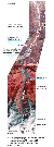
[3] The dismal reputation of the small Kolka Glacier residing at the northern slope of the Bokovoi
Range in the Central Caucasus, not far from the Kazbek Mountain, was attested by its new catastrophic
demolition of 20 September 2002 (see Figure 1).

|
|
Figure 2
|
[4] This catastrophe took place during deep twilight and was highly impetuous. As reported by
eyewitnesses, the glacier avalanche moved down the Genaldon Ravine at the rate of 200-300 km hour-1.
It travelled a way of 19 km for the time slightly more than 6 min and left a gigantic trail more than
500 m wide (Figure 2). The splashes of the leading wave over the sides of the ravine rose as high as
200-250 m. The natural obstruction for the further motion of the gigantic avalanche was the escarpment
of the Skalistyi Range, after the crossing of which the Genaldon Ravine lost its classic valley shape and
was transformed to a deep and narrow canyon. Nevertheless, this canyon did not serve as an obstacle for
a mud and ice wave traveling in front of the avalanche. The mudflow swell, as high as 30-40 m, travelled
over 5.5 km of the canyon, 30-80 m wide, at a rate of more than 100 km hour-1.
It was only after
it left the zone of the Skalistyi Range, where the canyon grows wider again, the wave began to slow down,
still travelling over a distance of almost 12 km. Only 2 km remained to reach the Gizel large
flat-land settlement. To sum up, the total size of the zone affected by the catastrophic processes amounted
to 37 km, covering an area of 15.7 km2
|
|
Figure 3
|
(Figure 3).

|
|
Figure 4
|
[5] The not numerous eyewitnesses of the avalanche movement,
namely, the natives of the Karmadon basin region, guessed
immediately that the Kolka Glacier was falling (Figure 4). The old
Osetian villages are located in this ravine high above the river,
and could not be reached by the avalanche. Since old times the
high-landers knew about the periodical landslides of this glacier.
The scarce data about the 1835 catastrophic landslide are followed
by the much more detailed description of the catastrophe of 3 July,
1902, reported by R. R. Leitsinger, including the death of 32 human
beings and 1700 of cattle. On the third day after the catastrophe,
one more avalanche rashed along the ravine, which killed four men
who were looking for the lost people. At that time the ice and rock
mass stopped at a distance of 6 km from the Skalistyi Range
escarpment. During the motion which began in the autumn of 1969 the
Kolka Glacier manifested itself as an obvious pulsating glacier. Its
surface was highly fractured, and its ice tongue moved at a variable
speed down the valley during five months, covering a distance 4.6 km
long. At that time the glacier did not leave its bed. No people were
killed (Figure 5). Note that all of the above mentioned catastrophes
took place with a time interval of 67 years between them.

|
|
Figure 5
|
[6] A new catastrophe turned out to be an absolutely unexpected
event. The historically formed view of the periodicity of the
Genaldon catastrophes suggested the hope of some 30 quiet years,
yet, the nature of the glacier turned out to be much more
complicated. The expected "time table" was violated.
[7] As follows from the official data, discovered by 10
November, 2002, were the remains of 18 dead people, 108 people
were not found. The dangerous zone included a 24-kilometer segment
of the local road. A small relatively new settlement, built at the
bank of the Genaldon River in the Karmadon Basin, was obliterated.
Two tourist centers, located at the outlet from the canyon, were
wiped off by a mud flow. More distant buildings were damaged
significantly. It should be noted that during the first weeks
after the catastrophe the damaged area grew in size at the expense
of the filling of the dammed lake produced by the right tributary
of the Genaldon River, which was dammed by ice avalanche.
[8] The Kolka Glacier has been of great interest as an unstable natural formation constituting
a threat as a potential hazard. The inspection of the catastrophe zone immediately after the event
allowed the estimation of its hazard and the first suggestions concerning the mechanism that had caused
it and its potential consequences.

Powered by TeXWeb (Win32, v.2.0).