
V. G. Nikolaev
Geological Institute (GIN), Russian Academy of Sciences
|
|
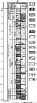
| Figure 1 |
On the north, the depression is bounded by exposures of Paleozoic rocks of the Gissar Range, along whose southern slope the major Gissar-Kokshaal (a.k.a. south Gissar) fault has been traced [Babaev, 1988]. On the east, the depression's boundary is established from the appearance of folded assemblages of the Paleozoic-Mesozoic Pamir block. They make up the Zaalaisky (Trans-Alai), Darvaz, etc., ranges, separated from the depression by the major Darvaz fault. In a southerly direction, the fault passes into the Ishkashym fault zone, which separates the southern part of the depression from the Hindu Kush folded piles. On the west, the roughly NS-trending Baisun-Kugitang anticlinorium separates the Afghan-Tajik depression from the Turan plate. At the crest of the anticlinorium, Paleozoic metamorphosed rocks are exposed. On the southwest, a narrow tract exists where the depression occurs in apparent continuity with the Turan plate structures. The southern boundary is provided by the roughly EW-trending Mirzavalang fault zone, south of which folded and weakly metamorphosed Permian and Triassic deposits of the Bandi-Turkestan zone are exposed. In the Afghan-Tajik depression, established are two major structural levels: basement and sedimentary cover.
The depression's basement is heterogeneous. In the interior of the depression, where sedimentary cover is thickest, no single drillhole has penetrated basement rocks. Their principal characteristics are thus inferred from the analysis of neighboring areas and by tracing basement zones on geophysical images. Currently, there is no consensus as for the basement structure of the area in point. The Precambrian-Paleozoic rock assemblages sitting in orogenic margins of the depression suggest that basement incorporates a variety of assemblages, from Precambrian on, that are known to occur on the Pamir block. Highly metamorphosed and dislocated Paleozoic geosynclinal rocks, widespread within Gissar and Paropamiz, are most likely to be available in basement stratigraphy as well. These have been recovered by sporadic drillholes in marginal parts of the depression (Dushanbe basin, north Afghan high). Not inconceivably, they pass toward the interior into Paleozoic quasi-cratonic cover overlapping Baikalian blocks [Bratash et al., 1970]. The fact that Permian-Triassic strata are encountered to the north, east, and south, suggests that they exist in basement of the Afghan-Tajik depression as well. In the vicinity of the Bandi-Turkestan Range and Puli-Khurmi, Triassic deposits (Doab and Puli-Khurmi Formations) are dominated by shales and sandstones with some tuffs and mafic lava flows. The Khanaka Formation of Triassic age in the Gissar Range region consists of redbed conglomerates with basaltic dikes. Permian and Triassic strata of varying thickness fill in graben-like structures. In Afghanistan, they are as thick as 3000 m, and to the north, on the Gissar range, a few hundred meters thick. Geophysical data suggest that in the depression's interior the Permian-Triassic assemblage occurs as a veneer.

|
| Figure 2 |
Within the former Soviet portion of the depression, depth contours are drawn approximately along the top of Paleozoic strata, and on the Afghan territory (much less well studied), structural basement surface, by convention, is taken to be represented by the top of pre-Jurassic strata. Hence the mismatch in depths to basement between these two regions. The above approach, however, gives a general idea on the structure of basement surface and sedimentary cover thickness.
The eastern slope of the depression is expressed very clearly. Over a stretch of 15-20 km, depth to basement increases from 0 to 10.0-12.0 km. This depth is greatest, up to 14 km, in the Cis-Darvaz region. This trough stretches along the entire length of the eastern slope of the Afghan-Tajik depression, widening to 25-30 km at the Vakhsh River and tapering out to several kilometers in a northeasterly direction. Although no data are available for the southern (Afghan) portion of the trough, the pattern of depth contours in the more westerly areas suggests its narrowing here as well. Similar depths (12.0-13.0 km) have been recorded in the Vakhsh megasyncline. In Afghanistan, its counterpart is a depression of pre-Jurassic strata as deep as 7.0-8.0 km. Depths of 10 km mark the most depressed portions of the Surkhan megasyncline. Similar depths to basement are recorded within the Kafirnigan meganticline. The depth-to-basement-surface map shows separate, very inconspicuous highs with 3.0-4.0 km depth contours outlining large positive structures of Meso-Cenozoic age. In the Babatag anticlinal zone, one finds a series of linear anticlinal and synclinal structures, separated by roughly NS- and EW-trending faults. Here, depth to basement ranges sharply from 12.0 to 7.0 km. The western slope of the Afghan-Tajik depression is gentler than eastern. In this area, basement surface shallows out from 7.0-8.0 km (as in the central part of the west Surkhan depression) to 3.0-4.0 km on the slopes of the southwestern Gissar meganticline.
In the Dushanbe basin, depth to basement shallows out from 6.0 km in the Ilyak fault zone on the south toward the north slope, where basement rocks emerge on the surface. This homocline is modified by a number of roughly EW-trending local scale structures. These are, primarily, a group of linear basins on the east of the sag, where depth to basement increases to 4.0 km. On the west of the sag, local scale structures are more equant in shape, but here a system of SW-trending faults is present.
In the southern north Afghan depression, the surface of pre-Jurassic deposits occurs at 2.0 km to 0, depth contours forming an equant high trending roughly EW. It was named "the north Afghan basement high" [Bratash et al., 1970]. Its northern slope is separated by a high-angle fault from the strongly depressed basin interior. It should be borne in mind, however, that in this area depth to basement may be much greater.
Therefore, in considering the depth-to-basement-surface structural map, three major portions are established in the Afghan-Tajik depression. The central portion shows roughly NS trending structures, and the northern and southern, roughly EW trending ones. The roughly EW trending parts are separated from the central one by major fault zones, whereas local scale structures are interfingered with each other.
More or less conspicuous angular unconformities divide sedimentary cover of the Afghan-Tajik depression into a number of structural assemblages [Barkhudaryan et al., 1988; Bratash et al., 1970; Varentsov et al., 1977; etc.]
The lower (subsalt) assemblage comprises Lower and Middle Jurassic deposits and Callovian-Oxfordian strata (Upper Jurassic). The lower part of the assemblage may consist of Rhaetian deposits, which are very thick (up to 2000 m) on the Darvaz Range and thin (37-100 m) on the south slope of the Gissar Range. The lower (Lower-Middle Jurassic) portion of the assemblage consists of alternating clays, siltstones, and sandstones, intercalated by coal seams and conglomerates. Here, recognized are deposits of terrestrial and marine origins. The Upper Jurassic section consists of a carbonate succession comprised of oolithic, algal, and coral limestones with ammonites. In the Afghan-Tajik depression, subsalt carbonate rocks are an issue of controversy. The point is that they have been drilled only at the depression margins (in the Baisun syncline and in the Dushanbe and north Afghan basins). In the central part of the depression, no Upper Jurassic carbonate rocks have been detected. Their presence is inferred either from geophysical data or from general geologic considerations. Synoptic studies [Bebeshev and Makarov, 1988] show that carbonate successions are spread throughout the Afghan-Tajik depression, but toward its northern and eastern boundaries they give way to carbonate and terrigenous and, ultimately, to nearshore terrestrial facies. Upper Jurassic carbonate successions range in thickness from 200-300 m (Baisun-Tau and Dudkash regions in Afghanistan) on depression slopes to 500-600 m in the depression interior.
The Upper Jurassic (Kimmeridgian-Tithonian) salt strata are of depressionwide extent. They are comprised of gypsum, anhydrite, and rock salt, intercalated by terrigenous rocks. In an easterly direction, terrigenous intercalations increase in number. Deposition of the salt strata began in a deep water (700-800 m) depression [Lebzin, 1972]. Further north, in the Dushanbe basin, the counterparts to salt strata (Gaurdak Formation) are their coeval carbonate and terrigenous rocks (Varzob Formation), deposited in a basin several meters deep [Luchnikov et al., 1973]. In places (as, e.g., in the Ilyak basin region), coeval reef bodies are inferred to exist. The thickness of the salt strata varies dramatically across the study area. In the Baisun-Kugitang zone, it ranges from 100 to 600-800 m. Toward the most downwarped portions of the depression, the thickness increases (ca. 1600 m on the Bayangora prospect on the Surkhandarya syncline). The Tuyun-Tau Hole, located on the south of the Kafirnigan zone, intersected salt ca. 3000 m thick and remained in salt to total depth. Salt deposits make pillows, domes, and bosses, and they are invariably involved in fold structures. Individual bosses cut through the entire thickness of the overlying deposits, Quaternary included, and are exposed on the surface (as at Khodzha-Mumyn, etc.).
Salt strata are overlain by a continuous assemblage incorporating Cretaceous and Paleogene deposits. Inside this assemblage, hiatuses and unconformities exist that have been traced across certain localities. The lower (pre-Albian) section consists of a redbed terrigenous formation of alternating clay, sandstone, gypsum, anhydrite, and, less frequently, dolomite and marl. Across the greater portion of the depression, this formation is areally consistent [Varentsov et al., 1977]. As one approaches depression slopes, the proportion of sand and coarse clastics in the stratigraphy increases. The Albian-Paleocene sub-assemblage is dominated by clayey carbonate rocks intercalated by gypsum and anhydrite. Marine facies of depression interior give way in narrow slope zones to coarse terrestrial clastics. In the stratigraphy of the Albian-Paleocene sub-assemblage, established are two areally consistent members of dense organic limestone. One member, 50-100 m thick, is confined to the Cenomanian Stage. The other belongs to the Bukhara Beds (Paleocene) and ranges in thickness from 60-70 m on depression slopes to 300 m in the depression interior. Lastly, the Eocene-Oligocene sub-assemblage, lying erosively on the Albian-Paleocene one, consists of marine clay, sandstone, limestone, and marl.
The thickness of Cretaceous-Paleogene deposits in the Afghan-Tajik depression is ca. 3000 m. These deposits decrease in thickness to a few hundred meters on depression slopes at the expense of individual sub-assemblages thinning out gradually. The thickness drops sharply on the arches of anticlinal structures. In this case, thickness reduction is due mainly to truncation of the upper horizons, and, to a lesser extent, to the lower stratigraphic horizons thinning out toward the arches.
Further upsection, the molasse assemblage rests, which makes the fill of the Afghan-Tajik depression. It spans most of the sedimentary cover stratigraphy. Virtually the entire stratigraphy of the assemblage is exposed on the surface, especially spectacularly along the eastern slope of the depression (Darvaz and Peter the First ranges, etc.).
|
| Figure 3 |
Note that the molasse assemblage lacks any traces of magmatic rocks. The nearest magmatic manifestations of Miocene age are reported far south of the Afghan-Tajik depression, beyond the Bandi-Turkestan fault. These include granite porphyry, monzonite, syenite porphyry, and nepheline syenite [Abdulla and Chmyrev, 1980].
Total thickness of the molasse assemblage in composite section is ca. 11,000 m. According to [Bratash et al., 1970], in northern Afghanistan it increases to 14,000-17,000 m. Thickness distribution, however, is nonuniform. Depression interior has elevated thicknesses of the upper portions of the stratigraphy, primarily, of the entire Kulyab assemblage. The Yavan-1 Hole penetrated molasse 5040 m thick and was completed in the Baldzhuan Formation (Lower Miocene) [Kondur et al., 1974]. In the eastern part (Cis-Darvaz region), by contrast, thicknesses are greatest (up to 6000-7000 m) in the lower sections of the stratigraphy.

|
| Figure 4 |
The next seismic sequence up the stratigraphy is correlative to Upper Jurassic (Kimmeridgian-Tithonian), Lower Cretaceous, and Upper Cretaceous (Cenomanian included). Its upper boundary is placed along T 2 horizon, matching Cenomanian limestones. In terms of its inner structure, seismic sequence III is diversified both vertically and laterally. Its lower portion consists of anhydrite and gypsum, intercalated by terrigenous rocks of the Gaurdak Formation (Kimmeridgian-Tithonian). On time sections, they are portrayed by chaotic record and it is due to the increasing thickness of these rocks that the entire sequence becomes thicker. On rare occasions, horizon T31, traceable over short distances, is confined to the salt strata surface.
The upper stratigraphic portion of this seismic sequence is composed of terrigenous deposits, divided into two lithologic units, the lower (Valanginian-Aptian) consisting of redbeds and the upper (Aptian-Cenomanian) of sandstones and siltstones intercalated by limestones. Overall, this part of the seismic sequence is parallel bedded. Many localities, however, yield chaotic record with occasional dipping events. This might be due to facies changes involving rock coarsening.
Up the stratigraphy, the Cretaceous-Paleocene seismic sequence is traceable depressionwide. Its upper boundary is provided by T1 key reflector. In the middle part of the seismic sequence, T21 horizon is recorded. It is readily traceable in synclinal structures and less well, on local scale highs. Below T21 horizon, the Upper Cretaceous (Turonian-Senonian) unit occurs, consisting of marly clays intercalated by limestones and marls. Within it, carbonate content increases upward, while lateral facies changes involve gradation into silty and sandy rocks. Above T21 horizon, marine deposits of Paleocene age occur, dominated by limestones with terrigenous intercalations. The inner architecture of this seismic sequence is distinguished by rather continuous parallel bedding, which becomes increasingly consistent up the stratigraphy. Occasionally, parallel events give way to oblique reflection configuration or chaotic record. This is particularly characteristic of the lower sub-assemblage. Such areas are small, 1-3 km in length.
On time sections across the Afghan-Tajik depression, the key horizon is T1; based on a wealth of data, it images the surface of Bukhara limestones (Paleocene), and it is usually represented by strong 2-6-cycle reflections. Above it, four seismic sequences are established, which are either separated by strong reflectors or have their distinctive wave patterns (Figure 3).

|
| Figure 5 |

|
| Figure 6 |

|
| Figure 7 |
Therefore, stratigraphically, sedimentary cover of the Afghan-Tajik depression is comprised of several structural assemblages, divisible into sub-assemblages. The lowermost one spans Jurassic subsalt strata. Most likely, in certain regions its lower part incorporates older, Triassic, and possibly also Paleozoic deposits. The next assemblage is composed of Upper Jurassic salt strata, architecturally very complex. It is overlain by a carbonate and terrigenous assemblage of Cretaceous to Lower Paleogene age. Lastly, the uppermost assemblage is Cenozoic molasse, bounded from beneath by the surface of the Bukhara limestones.

|
| Figure 8 |

|
| Figure 9 |
A fault system is likely to exist that modifies the structural surface of carbonates, although poor coverage precludes delineating this system clearly.
Overall, the subsalt assemblage (incorporating the two assemblages just described) is featured by relatively gentle structural units. Dip angles on limbs and slopes of local scale structures range from a few degrees to 15-20o. It is only near faults that dip angles are as high as 60-70o to vertical.
The salt strata of the Afghan-Tajik depression are of depressionwide extent. They make a variety of structural forms from salt pillows to domes and bosses. Salt structures strongly modify the architecture of the overlying assemblages. Certain salt bosses (e.g., Khodzha-Mumyn) cut through all the overlying deposits, including Quaternary.

|
| Figure 10 |
East of the Sherabad-Sarykamysh anticline, the compexly built Surkhan trough of northeastern strike is situated. Within it, a number of 2nd order positive and negative local-scale structures occur, as a rule, sharing fault boundaries with each other. In the most downwarped basins, the surface of Bukhara Beds is as deep as 5000-6000 m, whereas on anticlinal arches it shallows out to zero. The Surkhan trough is divided into two parts: western and eastern. On the west, the surface of Bukhara Beds lies rather gently, and on the east it is bent into a system of narrow linear folds trending northeast. As a rule, eastern limbs are steeper than western. In the eastern part, numerous faults are clustered, ranging in amplitude from a few hundred meters to a few kilometers. The dominant NE-SW trending faults are accompanied by a group of roughly EW trending faults of lower amplitude. They offset depth contours on northern blocks eastward relative to the southern blocks.
East of the Surkhan megasyncline and parallel to it, there stretches the Babatag anticline, making part of the Kafirnigan meganticline [Varentsov et al., 1977]. Tectonic stratigraphy of this anticline displays several thrust sheets. Overthrusting is greatest, up to 20 km, on the north of the anticline in Tajikistan [Kondur et al., 1974]. The anticlinal arch exposes Cretaceous and Paleogene deposits. The anticline consists of a series of brachyanticlines, separated by individual brachysynclines. Within these, the surface of Bukhara limestones plunges as deep as 2000-2500 m.
Most faults are nearly vertical normal faults. The largest faults are classed with this particular group. Roughly EW trending faults can be classed as transtensional faults. This applies especially to the faults of the eastern Surkhan megasyncline.
Anticlinal folds are often modified by small-amplitude overthrusts, not necessarily picked on time sections. One such overthrust has been validated by drilling on Lyailyakan prospect. The Lyailyakan 1 Hole penetrated a duplicated stratigraphy of the Lower Cretaceous (Barremian-Hauterivian-Valanginian). On time section, the overthrust is portrayed by repetition of key horizons and complication of record. Similar overthrusts have been detected on the Uchkyzyl, Kushtepe, etc., prospects.

|
| Figure 11 |
Another type of anticlinal structures is represented by folds on the western Surkhan megasyncline. The Konysai prospect displays a gentle anticlinal fold with symmetrical slopes. Dip angles on its slopes are 5-10o. Cretaceous and Paleocene deposits do not increase in thickness in fold arches. The lower section is noted for increased thickness of Jurassic salt strata. Here, a salt pillow is likely to occur, probably responsible for the anticlinal bend of Cretaceous-Paleocene deposits. Similar anticlines are Zarabat, Gadzhak, etc.
Within the Kafirnigan and Obigarm meganticlines and Vakhsh megasyncline, the surface of Bukhara Beds is bent into sharp anticlines and synclines, cut by numerous vertical faults and overthrusts. The linear structures range from 2-3 km to 5-6 km in width. They stretch for several tens of kilometers, and then either become arranged en echelon or terminate against large fault zones. The depth of the surface oscillates from 1-2 to 7-8 km. The surface of Bukhara limestones is deepest (6.0-7.0 km) in the interior of the Vakhsh megasyncline. In anticlinal fold zones, the depth to the surface is between - 1.0 and +2.0 km. In some cases (especially, in the Babatag anticlinal zone), Cretaceous deposits are exposed in anticline arches. On anticline slopes, surface gradients change sharply, from 10-20o to nearly vertical, and in the most complex structures reversed dips of limbs are observed, i.e., overturned folds are formed. Such anticlines are, e.g., Abdullaaka, Rengan, Kichik-Bel, etc. Over the greater part of the depression, linear structures trend roughly EW. However, as one approaches the northern parts, they swing smoothly northeast. In a southerly direction, Bukhara Beds rise generally to depths of 3.0-2.0 km. Anticlines and synclines lose their linearity to turn into slightly elongated highs and deeps. Depth oscillations are decreased to 1-2 km. The axes of these structures acquire NW-SE trends, and they terminate near the Alburz-Mormul fault zone.
|
| Figure 12 |
On the east, within the Kulyab megasyncline, structural units become more equant and flat. The megasyncline is a system of positive and negative zones trending roughly NS. On the north, at the junction of the Pamir and Tien Shan, structural grain becomes northeasterly, which is especially clear in the Vakhsh River valley. In this area, narrow Alpine-type dislocations, not infrequently with upside-down bedding attitudes, become once again dominant. The surface of Bukhara Beds is deepest (5.0 km) in the most downwarped structures. On anticline arches, this surface rises to 1.0-0 km. Very distinct is the eastern slope of the megasyncline (which is also the slope to the depression at large). In the Khozretishi Range region, this slope is expressed in the surface rising sharply from - 4.0 to +1.0 km. The slope gradient is ca. 45o. No data are available to trace the Kulyab megasyncline south, into Afghanistan, yet from general considerations the surface might rise another 1 or 2 km. This general uplift is modified by the Kokchi graben, where Neogene-Quaternary strata alone are ca. 12 km thick, and, accordingly, the surface of Bukhara Beds is at least 10 km deep.
In the northern Afghan basin, the surface of Bukhara Beds lies at depths of a few hundred meters in minor isolated basins. Most part of the basin is occupied by surface deposits of Jurassic to Paleocene age. Anticlinal folds of the Mesozoic assemblage are characterized by relatively gentle limbs and are slightly elongate in plan view. They trend NE-SW and are modified by rather sporadic low amplitude fault. On the north, the north Afghan basin is bounded by a belt of Eocene exposures, situated north of the Alburz-Mormul fault zone.
In the Dushanbe basin, the surface of Bukhara Beds rises from - 4.0 km on the south to +1.0 km on the north as a homocline. This homocline is modified by minor highs (Shaambary, etc.), equant and slightly elongated EW. The highs have low-gradient slopes and flat arches. Besides, a number of structural noses, modified by local-scale bulges, are observed. The structures are a few hundred meters to 1000 m in height. The south slope of the basin is separated from the Kafirnigan maganticline and Vakhsh megasyncline by the complexly built Ilyak fault zone [Kukhtikov, 1964; etc.]. The type of the Ilyak fault and its genesis remain unclear. This issue, both in the unexposed portion of the depression and in exposed mountain regions, has been addressed in many studies [Vasil'chikov et al., 1974; etc.], which arrived at no final solution. In recent years, Tajikistan has been covered by regional-scale CMP profiling. One profile intersected the Ilyak fault. It was surveyed at challenging geophysical and geologic conditions, such as sharp changes in the low velocity range, topographic contrasts of several hundred meters, etc. Despite the rather low quality of data obtained, time section analysis affords some preliminary conclusions on the structure of the Ilyak fault zone.

|
| Figure 13 |
Reliably enough recorded are horizons in the northern part of the profile (Sts. 170-271), lying within the Dushanbe basin. Here, events are picked from the boundaries identified as the base of the Pliocene, base of the Neogene, surface of the Bukhara Beds (Paleocene), surface of the Cenomanian, and surface of the Varzob Formation (Upper Jurassic). The horizon correlative to the top of the Callovian-Oxfordian carbonates is picked only between stations 159 and 170. In the region of Sts. 190-271, the reflectors are nearly flat. Between Sts. 170-180, they undergo a gentle synclinal bend, and further south, as far as the fault zone, they rise 0.2-0.3 s. The flat attitude is modified by a reverse fault, whose northern limb is upthrown some 0.3-0.4 s.
At the boundary of the Dushanbe basin and Kafirnigan anticlinal zone (Sts. 105-170), traceability of events throughout the upper section as deep as 3.0 s deteriorates dramatically. This is due to the utmost geologic complexity of the zone, where overthrust rocks are most highly deformed. Sporadic small bins afford restoring tentatively the structure of the area. It should be kept in mind that the structure is undoubtedly more complex than what is depicted in Figure 13b. The thrust plane is traceable nearly flatly as far as Sts. 120-130, after which it starts steepening out to eventually become nearly vertical. In the region of Sts. 100-130, one discerns a system of normal faults modifying the architecture of the uppermost thrust sheet. The lowermost thrust sheet, considering the bulge and chaotic record, is likely to contain Upper Jurassic salt strata. This is a setting they are known to occupy in virtually all the thrust piles of the Afghan-Tajik depression [Varentsov et al., 1977].
In the interval of Sts. 130-140 at a depth of 3.0 s and lower, a zone of abrupt loss of correlation is situated. In the Afghan-Tajik depression, major faults are associated with zones like this. In the region in point, the fault plane dips N at angles of 70-80o. From the north, it is onlapped by Upper Jurassic beds, and on the south no relationships with sedimentary cover are to be observed. Therefore, analyzing the seismic profile yields an intricate structural image for the Ilyak fault zone.
The upper molasse assemblage fills in the most depressed regions of the Afghan-Tajik depression. The molasse stratigraphy displays several unconformities. The upper unconformity, confined to the base of the Kulyab Group (Neogene-Quaternary boundary), is readily traceable in outcrops and between drillholes [Burachek, 1934; etc.]. This unconformity results from the Talbarsky orogenic phase. New seismic surveys resolve further unconformities in this assemblage and afford a more detailed characteristic of the pre-Kulyab unconformity.

|
| Figure 14 |
Near the fault, in Miocene-Pliocene deposits certain horizons thin out eastward, some pinching out to zero. This pattern is typical of debris cones. It thus can be inferred that in Tavildara-Polizak time, material was supplied from the arch of the eastern Donguztau folds, which is evidenced by complete erosion of strata, Paleocene inclusive, on fold arches.
Below the unconformity just described, one finds a marked horizon with some degree of unconformity in its overlying and underlying strata. Where bent most sharply, this horizon is onlapped on the east by both groups of strata. This pattern can be interpreted as being the surface of erosional incision or a fossil stream valley. Incision involves erosion of slope tracts, exposing strata directly on valley slope, the incised valley then being filled by flatly lying deposits. Precisely this sort of structure (its western slope) is seen in the profile. Valley formation, most likely, predates Boldzhuan time, although more rigorous constraints are not possible. Erosional incision, in fact, is a sort of unconformity, although its genesis is different. It can be driven, e.g., by a relative uplift of the area in point, without changes in its structural grain. For this reason, the pre-Boldzhuan unconformity is not classed with regional-scale ones, although a more detailed analysis of the study area might show its role to be greater.
Therefore, the molasse assemblage comes in two sub-assemblages: lower, incorporating Oligocene-Pliocene deposits, and upper, composed of Quaternary strata (in places including upper Pliocene deposits). These are very clearly discernible in the Kafirnigan and Obigarm meganticlines and in the Vakhsh megasyncline. Over the rest of the study area (Surkhan and Kulyab megasynclines, Dushanbe basin), these sub-assemblages are established only from a very inconspicuous angular unconformity on time sections. In the north Afghan depression, the molasse assemblage is very thin and not divisible into sub-assemblages. The lower sub-sequence in central portions of synclinal structures is featured by flat attitude with sporadic very gentle folds, with limbs dipping at 1-5o. In areas dominated by anticlinal folds in the earlier assemblage, strata of the lower sub-sequence at times have very steep attitudes, including overturned. This is especially typical of the Kafirnigan and Obigarm meganticlines, mainly on their slopes facing the Vakhsh megasyncline. Where the contact with underlying deposits is tectonic and un-sheared, the surface of the underlying assemblage is onlapped by Neogene strata. This is observable only on anticlines, whereas in synclines the overlying and underlying beds are nearly parallel.
The Quaternary sub-sequence of the molasse assemblage fills in the most downwarped portions of the study area. This sub-sequence occurs almost everywhere virtually horizontally. Only near modern active faults (Cis-Darvaz region, Babatag and Ilyak faults), do dips increase to 10-20o. Recent tectonic dislocations in the Afghan-Tajik depression have been described by [Trifonov, 1983]. These cluster mainly in the junction zone of Pamir and Tien Shan, where wrench faults, overthrusts, and other faults affecting attitudes of Holocene rocks are reported. In the depression's interior, sporadic Late Quaternary offsets are reported to be greatest along the boundaries of anticlines and synclines. These, as a rule, inherit pre-existing faults. The offsets are a few dozens of meters at the very greatest. Accordingly, dip angles of Quaternary beds change very little.
Basement of the Afghan-Tajik depression had been consolidated by the end of the Paleozoic. For lack of data on deep structure of the depression, it can be inferred conservatively that in Permian and Triassic times separate grabens existed on its site being filled in with terrigenous and volcanic deposits resembling the Khanaka Formation of south Tien Shan. It is not inconceivable that as early as Triassic time there existed quasi-cratonic cover.
During Jurassic time, the depression experienced steady-state sagging and, paleogeographically, it was a marine depression. In the Cretaceous, the depression had well-formed northern, eastern, and southern slopes and was likely to open to the west. The stratigraphy of the Jurassic assemblage displays individual beds whose thickness decreases gradually toward Paleozoic margin and on anticlinal arches (Karakurt structure in the Surkhan megasynclinorium, etc.). Otherwise, strata remain parallel and are traceable for great distances. This suggests syndepositional growth for local-scale highs in Jurassic time.
There had existed major faults. Thus, the Ilyak fault bounded the Dushanbe depression on the south. It was likely that by the Late Jurassic time the bench in the Moho took shape, as established by [Kulagin et al., 1976]. The fault plane dipped north, the fault itself representing a reverse fault. Mass motion was directed from the north. Vertical throw was ca. 1000 m, and horizontal separation, 1000-2000 m.
Environmentally, the Dushanbe depression was a shelf region to a large marine depression that spread far south. Topographically, the Ilyak fault most likely corresponded to continental slope. South of it, prior to deposition of salt strata, the depression was ca. 70-800 m deep [Lebzin, 1972], while to the north, in the Dushanbe basin, coeval sediments were accumulated in water depths of a few meters, as evidenced by algal limestones and nearbottom faunas [Luchnikov et al., 1973]. Such paleogeographic environments often give rise to barrier reefs [Shteingolts and Batalin, 1987; Zharkov, 1971]. Seismic section showing an area with chaotic record, delineated by very poorly recorded arcuate reflections, implies that at 2.5-3.0 s depths a reef body ca. 700-800 m thick is present. The presence of a reef is indirectly evidenced by anhydrite succession being here replaced by limestones and clayey dolomites of reduced thickness. This regularity of stratigraphic changes above reef buildups has been established for Jurassic deposits in southern Central Asia [Luchnikov, 1985].
Similar events must have taken place synchronously along the Alburz-Mormul fault, the north Afghan basin being a southern shelf to the marine depression.
Beginning in the Kimmeridgian-Tithonian, marine environments gave way to lagoon and nearshore marine ones, and Upper Jurassic salt strata began accumulating. These were formed only in the most downwarped part of the depression. Across the Ilyak fault, on the site of the Dushanbe basin, sulfates were replaced by carbonate and terrigenous deposits. On the Darvaz Range, these deposits consist of a clayey gypsum succession with sporadic salt intercalations. The north Afghan trough was uplifted, only its separate tracts accumulating terrigenous deposits.
In Cretaceous-Paleocene time, after Upper Jurassic salts had accumulated in the
Afghan-Tajik depression, terrigenous sedimentation continued in a relatively shallow
water basin. The climate turned considerably more arid and sediment provenance
regions grew more active, resulting in increased terrigenous component of deposits.
Preexisting principal structural units remained intact. In the Dushanbe basin and
on the
north Afghan basement high, thin (a few hundred meters) sedimentary successions were
formed. The greatest thickness (2500 m) is recorded in depression interiors.
As one
approaches the western, northern, and southern limits of the deepest region, thickness
drops to 1700 m. Thickness reduction is due most likely to gradual thinning
of
individual layers. However, cases have been recorded where individual horizons onlap
the surface of the underlying Jurassic strata. Thus, in the Surkhan megasyncline,
between the western slope of the Uchkyzyl brachyanticline and the Angor
brachyanticline, Lower Cretaceous deposits (between T2 and T3 horizons) increase in
thickness from 0.8 s to 1.1 s--i.e., at Y dens 5000 m/s, by ca. 1000 m.
Here, Lower
Cretaceous strata occur horizontally, each bed being consistent in thickness, while
the
Jurassic surface plunges at an angle of ca.
20o. Accordingly, it can be inferred that in
pre-Cretaceous time topographic relief equaled several hundred meters, to become
filled in with sediments in Early Cretaceous time.
5000 m/s, by ca. 1000 m.
Here, Lower
Cretaceous strata occur horizontally, each bed being consistent in thickness, while
the
Jurassic surface plunges at an angle of ca.
20o. Accordingly, it can be inferred that in
pre-Cretaceous time topographic relief equaled several hundred meters, to become
filled in with sediments in Early Cretaceous time.
Deposits between horizon T2 (surface of the Cenomanian) and T1 (surface of the Bukhara Beds) are consistent in thickness. This implies relatively quiescent tectonic regime. The same is evidenced by sedimentologic composition of deposits, represented by limestones spanning large areas. Prior to limestone deposition in the Paleocene, the study area must have experienced general uplifting. It took a brief timespan for previously piled sediments to be eroded and redeposited. At the same time, individual incisions were formed. On the Pashkhurt prospect, strata below T1 horizon are bent and are overlapped by this horizon at higher angles. Inside the lens, chaotic record with vague oblique bedding is observed, suggestive of stream valley deposits. Incision is ca. 2 km wide and ca. 0.2 s deep, which gives ca. 400 m at Ydens = 4000 m/s.
During the Cretaceous, topographic relief suffered leveling, deeper water parts being filled in with carbonate and terrigenous deposits. Topographic relief had been leveled off almost completely by the beginning of the Paleogene. Paleocene limestones of the same thickness (50-200 m) span the entire Afghan-Tajik depression, and were likely to spread continuously far northward [Davidzon et al., 1982]. On the south, these reached as far as the Gerirud fault zone.
Paleomagnetic data [Bazhenov, 2001; Bazhenov and Burtman, 1990] suggest that in the Early Cretaceous, the central part of the northern Pamir arc started moving northward. The Darvaz flank of the arc rotated ca. 60o counterclockwise after the Early Cretaceous. While between the Early Cretaceous and Paleogene northern Pamir and Hindu Kush (south part of the Darvaz flank) migrated at roughly the same rate, in post-Paleogene time the Pamir moved very rapidly, and Hindu Kush slowly. According to I. L. Bazhenov and V. S. Burtman, since the Early Cretaceous tectonic zones of the northern Pamir migrated at least 300 km (a more likely value being 600-700 km) toward Eurasia, with the greater amount of migration falling in post-Paleogene time.
Anticlinal fold zones in the Afghan-Tajik depression started forming at ca. the Paleocene/Eocene transition. Originally, they must have trended EW in the depression interior and NNE-SSW between the Pamir and Tien Shan. These zones modified dramatically the quasi-cratonic architecture of Jurassic, Cretaceous, and Paleocene rocks. Folds were formed through horizontal compression (driven by the movement of mountain masses on the east) and through halokinesis. In the former case, a key role was played by faults (normal and reverse faults and minor overthrusts), and in the latter, by simple flexure of strata. Folding took place in an environment of general uplift of the study area and involved erosion of previously accumulated sediments.
A new marine transgression set in in Eocene time. It spanned the entire depression and continued until the end of the Paleogene. In Eocene-Oligocene time, along the southern slope of the Dushanbe basin, there existed the "Ilyak swell," a morphologically expressed roughly EW trending rise [Davidzon and Kukushkin, 1973]. On time section, its traces are recorded by the thinning and erosion of Eocene-Oligocene strata near the fault zone and by their right-side-up attitude in the northern limb and beneath the fault plane in the southern limb.
From the Late Oligocene on, the Afghan-Tajik depression was involved in a major orogenic pulse that affected the entire Alpine belt. This timespan witnessed dramatic subsidence of the depression area and uplift of its surrounding folded piles. The strongest subsidence events in the Middle Paleogene-Neogene time were restricted to the depression interior, the Vakhsh megasyncline. Precisely there the greatest sediment thicknesses (up to 5000 m) are recorded. In approaching anticlinal zones and depression slopes, Oligocene-Miocene deposits pinch out. The north Afghan high was uplifted, and no sediments accumulated on it (except locally); from that time on, it existed as an uplifted ablation area.
In most cases, beginning with the lower parts of the assemblage, beds are found onlapping their underlying substrate without changing perceptibly in thickness. This is easy to see on many profiles across the anticlinal folds. The presence of debris cones, fossil incisions, and facies changes precludes unequivocal quantification of the past topographic relief, although it can be assessed at 2-3 km at the least.
At the Paleogene/Neogene transition, a major tectonic rearrangement took place. It was at that time that narrow zones of anticlinal and synclinal folds in the depression interior (Kafirnigan and Obigarm meganticline) with their imbricate oppositely directed structures took their final shape.
Early in the Quaternary, a new subsidence pulse took place that affected only axial parts of negative structure. During this subsidence event, there formed a topographic relief strongly resembling the modern one, and which became sediment-filled. Terrigenous material was discharged as debris cones and valleyside and stream facies. Loess deposits became widespread. All the rocks of the Quaternary assemblage rest virtually horizontally. Sporadic cases of tilted bedding near modern faults have been reported [Trifonov, 1983].
Currently, the entire Afghan-Tajik depression is a locus of slow subsidence, whereas its surrounding mountain edifices experience uplift. Geodesy surveys have shown that the Peter the First and Gissar Ranges are converging at 1.5-2.0 cm/yr [Bazhenov and Burtman, 1990]. The northeastern part of the Vakhsh Range migrates southeastward along the strike of the tectonic zone at 2.0 cm/yr. This shows the Pamir arc to be currently under construction. No data, however, are available to suggest horizontal displacements in the depression proper. Minor extension might operate in the Kokcha graben region.
Therefore, sedimentary cover of the Afghan-Tajik depression was formed in two major phases. The early, Jurassic-Paleocene, is featured by quasi-cratonic evolution with certain distinctions due to the depression making part of an active zone. The late, Eocene-present, is distinguished by dramatic subsidence events of many kilometers, and by linear imbricate structures forming in the cover.

|
| Figure 15 |
The late phase comes in two sub-phases, the lower (pre-Quaternary) being more dynamic. This period includes contrasting tectonic movements, both vertical and horizontal, short-lived periods of dramatic rearrangement, and formation of strong topographic relief alternating with relative quiescence and sediments filling topographic lows. The upper sub-phase of the late phase was dominated by vertical movements in the depression.
What is the driving mechanism of linear folding in the depression's sedimentary cover? Several viewpoints exist on this issue [Varentsov et al., 1977; Zakharov, 1970; etc.]. Bazhenov and Burtman [1990] and Bazhenov [[2001], considering that the Tajik structural arc (meaning the folds of the Afghan-Tajik depression) is discordant to the relatively old Darvaz-Kopetdagh arc and conformable to the young Pamir arc, surmised that it may have resulted from tectonic flow of mountain masses, directed westward from the apex of the Punjab syntaxis. The same writers analyzed strike-slip motions to show that, as the Punjab syntaxis was forming, folds in the depression migrated westward, along the dextral south Gissar (Ilyak) strike slips and the sinistral Alburz-Mormul strike slip. South of the latter, the south Afghan block migrated westward along the Gerirud strike slip fault. It is hard to agree with all the particulars of this concept. Thus, the nearly EW trend of folds on the north and south and their proximity to the Pamir block remain unexplained. While on the north this is rather easy to attribute to the presence of the Meso-Cenozoic sedimentary basin between the Pamir and Tien Shan, no such basin exists on the south, where folds virtually butt against the zones of roughly EW trending strike slips. Displacement along roughly EW trending strike slips is not very convincing, either.
Let us discuss such displacement using a case study of the Ilyak fault with due account for new data. Analyzing seismic profiles yields the following scenario for the Ilyak fault zone in the Paleogene (post-Bukhara Beds time) to Neogene (the structure of the zone is given in Figure 13).
At the Paleogene/Neogene transition, a major tectonic rearrangement took place. The thrust sheet (lower allochthonous unit) incorporating Cretaceous and Paleogene deposits, with Kimmeridgian-Tithonian anhydrite and salt successions acting as lubricants, propagated a few hundred kilometers northward. During propagation, the sheet, especially its leading edge, was deformed. This thrust sheet overrode the Ilyak fault, dating from Jurassic time. The sheet continued propagating in pulses throughout Neogene time. Most likely, it underwent internal slicing. A thrust sheet incorporating Cretaceous, Paleogene, and Miocene strata (upper allochthonous unit) was thrust over the anticlinal structure already in existence, approximately, at the Miocene-Pliocene boundary. Horizontal separation exceeded 10 km; i.e., this thrusting pulse was stronger than the previous one. Then, due to general subsidence of the area, the imbricate pile was overlain by a veneer of Kulyab assemblage deposits. Weak horizontal movements took place before the Quaternary. This is evidenced by tilted strata in the lower stratigraphy of the Kulyab assemblage on the south slope of the Dushanbe basin. During the Middle to Late Pleistocene and Holocene, vertical movements generating thin flatly lying sedimentary cover took place.
Consequently, the Ilyak fault contains two fault units of contrasting ages. One of these, the Ilyak fault proper, which existed until the end of the Cretaceous, was formed by vertical movements with minor horizontal component and is classed with deep seated faults, reaching into the upper mantle. The other unit is the Ilyak thrust, which propagated during the Neogene-Quaternary and consisted of two sheets. It was generated by complex horizontal movements in the region. A genetically similar feature is the major Babatag thrust, established by seismic surveying and drilling; it trends roughly EW with horizontal separation of ca. 20 km [Kondur et al., 1974]. The uppermost sheets of this thrust propagated far north, into the Khanaka anticline region, located nearly in the center of the Dushanbe basin. The contrast in Neogene strata enabled [Vasil'chikov et al., 1974] to trace the surface exposure of the thrust plane in this area. Most likely, the thrust unit established on top the Ilyak fault makes part of a larger slice. To a first approximation, it belongs to the northern terminus of the Karshitau thrust, traceable further south in a roughly EW direction.
We can put forward the following scenario for the generation, undoubtedly multiple phase, of imbricate thrust architecture for sedimentary cover in the interior Afghan-Tajik depression. Following dramatic surface subsidence in the mid-Paleogene and emergence of mountainous topographic relief, the most downwarped region (Vakhsh megasyncline) became the locus for the previously formed folds to bend into from the west and east directions, accompanied by overthrusting and nappe formation. These processes were facilitated by salt strata providing lubrication. Further on, in the Neogene, motion of the Pamir block produced depressionwide stresses, directed northwest and west. This resulted in flexure of the previously formed fold zones (and, needless to say, in their complication), strongest where subsidence was deepest. This phase gave rise to the first thrusting event in the Ilyak fault zone. Simultaneously, along the southern strike slips (Alburz-Mormul and Gerirud), the folds in south parts of the roughly EW trending meganticlines acquired northwesterly strike. Here, these folds did not bend because of lower topographic relief, thinner deposits, and higher crustal rigidity. Owing to the same reasons, on the south of the depression there formed local-scale strike slips, restricted to folds and highlighting their northwesterly trend. These strike slip faults, rather than being limited by the major roughly NS trending Darvaz shear, crossed it and are traceable into the fold area. Lastly, in pre-Quaternary time, a new tectonic pulse in the depression uplifted the Pamir block some 4-5 km. Pressure from uplifted rock masses on the depression cover was released in the weakest zone of dislocations and enhanced motions along ancient strike slip planes. Virtually no restructuring took place west of the Kafirnigan meganticline, within the Surkhan megasyncline. Rock pressure also made for a new northward shift of the upper thrust unit in the Ilyak thrust region. Simultaneously, Pamir assemblages were thrust over westward along the Darvaz strike slip, following the empty space backthrusting model. Hence, imbricate folded depressions are polygenetic in origin and were shaped by a variety of causes.
The Afghan-Tajik Cenozoic depression is classed with "labigenous" structures, which are equant in plan view, have thick sedimentary fill, and continental crust attenuated with respect to their surrounding regions. Evolution of all these structures either involves a sagging episode followed by sediments filling in topographic lows thus formed, or a phase or rapid subsidence with sharply increased sedimentation rates. Among such features are the Pannonian, South Caspian, Black Sea, etc., depressions [Nikolaev, 1993]. The Afghan-Tajik depression is distinguished by the presence of conspicuous linear dislocations in its sedimentary cover, that are modified by major overthrusts and nappes. This might be due to the depression's proximity to high mountain regions (thus, Pamir's average altitude is assessed at 4000 m), exerting strong lateral pressure. A closely similar feature is the Tarim depression, situated eastward of the Pamir between western Kunlun and Chinese Tien Shan. Studying the Tarim depression should become a follow-up on the study of structures of this type, especially in view of the extensive geophysical surveys performed in Tarim.
"Labigenous" structures (whose tectonotype is furnished by the best understood Pannonian depression) are encountered worldwide in the Cenozoic (e.g., the Maracaibo depression in South America, etc.), but their fossil counterparts, e.g., the Peri-Caspian depression in the Devonian, are known as well. In other words, they were formed at different phases of the global evolution.
Abdulla, Sh., and V. M. Chmyrev (Eds.), Geology and Economic Mineral Deposits of Afghanistan. Book 1. Geology, 535 pp., Nedra, Moscow, 1980.
Babaev, A., Tectonic boundary between the Gissar-Alai and the Tajik depression (in Russian), Byull. Mosk. O-va Ispyt. Prirody, Otd. Geol., 63, (3), 23-30, 1988.
Barkhudaryan, A., D. Dement'ev, and V. Nikolaev, Unconformities in sedimentary cover of southwestern Tajikistan: Seismic evidence (in Russian), Dokl. Akad. Nauk Tajik. SSR, 3, 113-118, 1988.
Bazhenov, M. L., Tectonic and paleomagnetic studies and the history of horizontal movements in Middle Asia from Permian time to present (in Russian), Doctoral thesis, 49 pp., Moscow, 2001.
Bazhenov, M. L., and V. S. Burtman, Structural Arcs of the Alpine Belt: Carpathians-Caucasus-Pamir), 167 pp., Nauka, Moscow, 1990.
Bebeshev, I. I., and Yu. V. Makarov, Paleogeography of the Afghan-Tajik depression in Late Jurassic time, in Evolution of Carbonate Deposition through the Earth's History, pp. 223-238, Moscow, 1988.
Bekker, A., Tectonics of the Afghan-Tajik depression (in Russian), Geotektonika, 1, 76-82, 1996.
Bratash, V. I., S. V. Egupov, V. V. Pechnikov, and A. I. Shelomentsev, The Geology and Petroleum Potential of Northern Afghanistan, 288 pp., Nedra, Moscow, 1970.
Burachek, A. R., Tertiary Terrestrial Deposits of Southwestern Tajikistan, Trudy Tadzh. Kompl. Eksp., issue 4, 1934.
Davidzon, R. M., G. P. Kreidenkov, and G. Kh. Salibaev, Stratigraphy of Paleogene Deposits of the Tajik Depression and Adjacent Areas, 119 pp., Donish, Dushanbe, 1982.
Davidzon, R. M., and R. M. Kukushkin, On the history of evolution of local structures of the Dushanbe depression and the northern part of the Babatag uplift in the Late Paleogene, in Issues of the Petroleum Potential of Tajikistan, Trudy TO VNIGRI, 5, issue 142, 112-126, Donish, Dushanbe, 1973.
Kondur, V. P., L. M. Saf'yan, and A. M. Marsal, Principal results of stratigraphic drilling in unexposed areas of southwestern Tajikistan, in Issues of the Petroleum Potential of Tajikistan, Trudy TO VNIGRI, 6, issue 159, 21-31, Donish, Dushanbe, 1974.
Kukhtikov, M. M., Inter-zone marginal faults of the Gissar-Alai folded area, paper presented at XXII IGC, Delhi, Acad, Sci. Tajik SSR, Dushanbe, 1964.
Kulagin, V. K., M. V. Kulagina, and E. G. Topar, On deep structure of the junction of the Tajik depression, South Tien Shan, and Pamir, in Issues of Seismic Zonation of the Tajik Territory, pp. 84-107, Donish, Dushanbe, 1976.
Lebzin, E. V., Paleotectonic conditions of formation of major structural units and related petroleum accumulation zones in the Afghan-Tajik depression and adjacent areas, in Issues of the Petroleum Potential of Tajikistan, Trudy TO VNIGRI, 4, issue 133, 3-34, Donish, Dushanbe, 1972.
Luchnikov, V. S., Prediction of buried reefs from composition and structure of their overlying evaporitic assemblage, in Geology of Reefs and Their Petroleum Potential (abstract), All-Union Conf., 107 pp., Karshi, 1985.
Luchnikov, V. S., L. V. Strelets, and N. D. Yushina, Sedimentologic and paleoecologic characteristic of the Upper Jurassic deposits of the south slope of the Gissar Range, in Issues of the Petroleum Potential of Tajikistan, Trudy TO VNIGRI, 5, issue 142, 146-155, Donish, Dushanbe, 1973.
Nikolaev, V. G., Cenozoic terrestrial rift-related and labigenous structures (structure and development of sedimentary cover), Doctoral thesis, 47 pp., GIN RAS, Moscow, 1993.
Shcherba, I., Polizak Formation and its stratigraphic counterparts in Neogene molasse of the Afghan-Tajik depression (in Russian), Dokl. Akad, Nauk SSSR, 246, (1), 175-178, 1979.
Shcherba, I. G., Explanatory note to the lithotectonic column of Cenozoic molasse of the Afghan-Tajik depression (comments to Appendix 17, in Veroff. Zentralinst. Phys. Erde, 6, 173-186, 1982.
Shteingolts, V. L., and Yu. V. Batalin, Paragenesis of Domanik-like and halmeic deposits of various hydrochemical types, in Sedimentary Assemblages and Environments of Their Formation, pp. 85-99, Nauka, Sib. Otd., Novosibirsk, 1987.
Trifonov, V. G., Late Quaternary Tectonism, Trudy GIN Akad. Nauk SSSR, issue 361, 224 pp., Nauka, Moscow, 1983.
Varentsov, M. I., Z. I. Aleshina, and G. E. Kornienko, Tectonics and Petroleum Potential of the Tajik Depression, 108 pp., Nauka, Moscow, 1977.
Vasil'chikov, M. V., R. D. Melamed, and L. M. Saf'yan, On the issue of the southern boundary of the Dushanbe depression, in Issues of the Petroleum Potential of Tajikistan, Trudy VNIGRI, 6, issue 159, 72-78, Donish, Dushanbe, 1974.
Yanshin, A., The issue of median masses (in Russian), Byull. Mosk. O-va. Ispyt. Prirody, Otd. Geol., XL, (5), 8-39, 1965.
Zakharov, S. A., Evolution of Tectonic Concepts in Tajikistan and Zone Tectogenesis Hypothesis, 306 pp., Donish, Dushanbe, 1970.
Zharkov, M. A., On intermediary depressions of the epochs of salt deposition and paragenetic relationship with salt strata of oil and gas fields, in Issues of the Petroleum Potential of Siberia, pp. 163-185, Nauka, Novosibirsk, 1971.