
T. P. Belousov, Sh. A. Mukhamediev, and S. F. Kurtasov
Schmidt United Institute of Physics of the Earth, Russian Academy of Sciences (UIPE RAS)
Rock jointing, one crucial characteristic of upper crustal layers, is nearly ubiquitous in rocks of various origins and ages. Joints are not chaotic, but always show a regular quasi-periodic or roughly parallel arrangement. The rock jointing phenomenon has long been a challenge to researchers. A record of studies on rock jointing in North America and Western Europe spanning over 100 years is presented in, e.g., the overviews [Hancock, 1985; Pollard and Aydin, 1988]. These overviews, however, do not mention the weighty contribution to this issue from Russian workers. Their results are reflected in, e.g., synoptic sections of [Chernyshev, 1983; Grachev and Mukhamediev, 2000; Permyakov, 1949; etc.].
Students of jointing focus primarily on the number and orientation of joint systems, as well as their genesis and possible links with stresses operating in the earth's crust. To date, no generally accepted approach to these issues has been developed. The state of the art in identifying joint sets, mainly in cratonic areas, is presented in, e.g., [Grachev and Mukhamediev, 2000].
The key role played by rock jointing in certain processes addressed by solid earth sciences necessitates the search for various measures for its quantification. Over the recent decades, measures have been introduced to describe deformation properties, strength, damage, and permeability of fractured rocks. Various forms of second and fourth rank tensors constructed on vectors of single poles to joint planes were proposed in [Cowin, 1985; Kawamoto et al., 1988; Lee et al., 1995; Oda, 1986; Salganik, 1973; Swoboda et al., 1998; etc.]. The respective tensors were termed "jointing tensor,'' "structural tensor,'' "permeability tensor,'' "damage tensor,'' etc.
We address two aspects of joint orientation studies in the Central Kyzyl Kum region:
|
|
| Figure 1 |
In the end of the 20th century, south of the Central Kyzyl Kum Mtns. several strong earthquakes took place over a comparatively short period. The first, M = 7.0 quake, was recorded on April 8, 1976. Subsequent shocks occurred on May 17, 1976, with M = 7.3, on June 4, 1978, with M = 6.2, and on March 19, 1984, with M = 7.2 [Graizer, 1986]. Almost immediately thereafter, the Institute of Physics of the Earth of the USSR Academy of Sciences organized seismologic expeditions to establish macroseismic aftereffects of the quakes. These interdisciplinary studies included joint measurements. In the frames of this exercise, T. P. Belousov and A. L. Teremetsky measured over 18,000 joints in various lithologies of different ages. This paper presents results of processing and interpretation of their data.
The Central Kyzyl Kum region is located within the Syr-Darya segment of the Turan plate, part of the Misian-Scythian�Turan post-Paleozoic craton [Khain, 1977; etc.]. The study area is bounded in the east by the transverse West Tien Shan fault [Rezvoi, 1962] and in the north and northeast, by the west flank of the northern Nurata fault, separating it from the Syr-Darya basin. In the west-southwest, the uplifts are controlled by the west flank of the Kuldzhuktau-Aktau fault, and further south, by the Bukhara fault, separating the Central Kyzyl Kum from the Amu-Darya basin.

|
| Figure 2 |
Basement of the study region was formed under the impact of two stages of Paleozoic orogeny. Caledonian tectonic movements in the first half of the Paleozoic (Cambrian to Early Devonian) affected the Riphean craton, resulting in NNW trending folded edifices. Hercynian orogenic movements (Middle Devonian to Permian) shaped structural features trending WNW and roughly E-W [Geology..., 1972; Ibragimov et al., 1973]. The Hercynian stage of tectonic history over most part of the Turan plate terminated, and in the end of the Permian to the beginning of the Triassic the study area entered a cratonic phase [Petrushevsky, 1955; etc.].
In the second half of the Triassic to Jurassic, the Central Kyzyl Kum region represented a marine basin with individual insular uplifts on the site of the present-day mountains. In the Late Jurassic, general subsidence in the region became somewhat stronger, with terrigenous deposits giving way to lagoon and marine sediments [Geology..., 1972; Ibragimov et al., 1973].
In the Early and Middle Paleogene to the first half of the Neogene, crustal subsidence in the Central Kyzyl Kum region began slowing down. The first signs of neotectonic reactivation, accompanied by invigoration of uplifting, became manifest in the Miocene to Pliocene [Chediya, 1971, 1972, 1986; Shultz, 1948, 1955, 1962; etc.]. In the terminal Pliocene to initial Pleistocene, a decline in tectonic movements took place [Geology..., 1972; Krestnikov et al., 1979; Yuriev, 1967], which terminated in the beginning of the Middle Pleistocene. It was not until ca. 300 ka that the study region became once again the site of vigorous uplifting [Krestnikov et al., 1979, 1980].
Arches of certain neotectonic uplifts in the Central Kyzyl Kum region display sporadic metamorphic basement outcrops represented by crystalline schist, gneiss, quartzite, and sandstone intercalated by dolomite and limestone. Their inferred age is Late Proterozoic [Geology..., 1972; Ibragimov et al., 1973; Khain, 1977]. Paleozoic deposits are more widespread, their stratigraphic succession falling into Caledonian and Hercynian structural stages, comprised of several substages each (Figure 2).
The Caledonian structural stage is subdivided into the Cambrian-Lower Silurian and Upper Silurian-Lower Devonian structural substages [Geology..., 1972; Ibragimov et al., 1973].
The lower part of the section of the Cambrian-Lower Silurian structural substage has not been established firmly, and it is only represented by sporadic outcrops in the vicinity of the Auminzatau and Tamdytau Mtns., composed of shale, limestone, and dolomite. Ordovician deposits were encountered in the Bukantau, Tamdytau, Aristanatau, and Kuldzhuktau Mtns. These are represented by shales with intercalations and lenses of chert, limestone, marble, gravelstone, sandstone, siltstone, a shale-sand member, and mafic extrusives and volcanics. The Upper Ordovician-Lower Silurian sections are divided into two types, terrigenous-carbonate and chert-carbonaceous shale [Akhmedzhanov, 1970]. In the Kuldzhuktau Mtns., terrigenous-carbonate deposits (gray sandy limestone intercalated by siltstone and shale, dolomite, and dolomitized limestone) are widespread. In the Tamdytau Mtns., the Lower Silurian is represented by brown fine-grained sandstone, siltstone, and clayey and carbonaceous clayey mudstone and siliceous, carbonaceous, and clayey sericite shales. In places, the upper part of the structural substage displays alternating layers of gravelstone, sandstone, and siltstone. This type of section is characteristic of the northern Tamdytau Mtns.
Terrigenous and carbonate deposits of the Upper Silurian-Lower Devonian structural substage are exposed in the Kuldzhuktau, Aristanatau, and northern Tamdytau Mtns. Lower stratigraphic horizons are represented by gravestone, sandstone, and siltstone with sporadic thin intercalations and lenses of limestone. Further upsection, a member of limestone and dolomite intercalated by sandstone and shale occurs.
The Hercynian structural stage in the Central Kyzyl Kum comprises the Middle-Upper Devonian, Carboniferous, and Lower Permian structural substages. The Middle-Upper Devonian substage is represented by a carbonate formation composed of dolomite, dolomitic and marble-like limestone, schist, and, less frequently, gneiss and anhydrite. The base is made up of redbed sandstone and conglomerate. The Carboniferous structural substage in the Bukantau and northern Tamdytau Mtns. is composed of massive limestone intercalated by siliceous limestone and molasse deposits, pierced by Upper Carboniferous granite and granodiorite massifs; porphyritic diabase members are encountered. In the Tamdytau and Kuldzhuktau Mtns., the Middle-Upper Carboniferous strata are comprised of carbonate and terrigenous deposits, classified as flysch. These rocks are pierced by granite-granodiorite bodies of Upper Paleozoic age.
Rocks of the Lower Permian structural substage in the Central Kyzyl Kum region occur sporadically. These are dominated by molasse, granite, and granodiorite. The Upper Permian�Lower Triassic substage within the study region is lacking [Ibragimov et al., 1973; Khain, 1977].
Mesozoic and Cenozoic rocks in the Central Kyzyl Kum region are mainly exposed along the periphery of uplifts. These are represented by Cretaceous, Paleogene, and Neogene deposits (conglomerate, sandstone, clay, dolomite, limestone).
This section discusses methods prerequisite while handling the issues of interpretation of rock jointing in the Central Kyzyl Kum region, posed in Introduction.
At each station in the Central Kyzyl Kum region, strike-and-dip measurements were taken on 100 joints. Measurements were taken exceptionally at natural exposures. The initial phase in field data processing is graphical visualization of joint planes on stereograms. This study makes use of the Wulff equal-angle stereographic projection. For the sake of definiteness, we assumed an upper-hemisphere orientation for normal vectors to joint planes.

|
| Figure 3 |
Field measurements of orientations
N, referring to an individual exposure or part
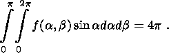
thereof, are a random sample of the continuous orientation function
f(
where
a and
b are the polar and azimuthal angles of the spherical
coordinate system. The
function
f(
The function
f(
This natural normalization implies that, with a chaotic (equiprobabilistic) joint
distribution,
f(
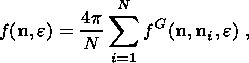
In order to reconstruct continuous distributions of joint orientations (pole densities),
field measurement data are put to a smoothing transform. Assessing the pole density
f( n, e) consists in juxtaposing
fuzzy spikes from measured joint orientations:
where
fG( n, ni, e)
is the spherical Gaussian distribution with a distance
e, whose center
coincides with the pole
ni of the
i th joint. In (3), summation is carried out over all the joint
orientations measured. The dispersion parameter
e must be so chosen that individual spikes
from measured orientations overlap, but, at the same time, essential characteristics
of the
distribution remain undistorted.
Summation of spikes from individual poles yields the smoothened function
f( n, e),
which approximates well the true pole density
f(
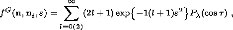
The spherical analog of the two-dimensional Gaussian distribution is not expressed
through elementary functions, and its distribution law is written as follows
[Savelova and Bukharova, 1996]:
where
Pl( cost)
is Legendre polynomials,
t is angular distance of the vector
After calculating the pole density
f( n, e) on a regular grid over
the entire spherical
projection area, pole density contours are constructed in order to obtain a graphical
visualization of the joint orientation distribution. With a continuous function,
drawing
contours is a simple task. A quantitative pole pattern corresponding to the pole
array in
Figure 3a
is given in Figure 3b. In all the pole patterns presented, level lines were spaced
at 0.5
density level units of the chaotic distribution.
Not infrequently, the character of jointing can be grasped at a first glance at pole
densities. However, in order to rule out subjective bias, automatic identification
of
statistically significant maxima ("joint sets'') in the empirical pattern of pole
distribution density is indispensable
[Grachev and Morozov, 1993;
Grachev and Mukhamediev, 2000].
First, all the local density maxima are identified. Some maxima correspond to real
joint sets,
while others emerge as artifacts of the statistical nature of measurements.
An example of joint analysis is depicted in Figure 3b, showing
four joint sets identified
from an exposure of Lower Silurian limestone in the Central Kyzyl Kum region. Three
of
these are bedding orthogonal.
A wealth of mathematical methods for the automatic classification of data into
homogeneous groups of objects (clusters, taxa) have been elaborated
[Aivazian et al., 1989].
Certain cluster algorithms were used for processing joint measurements in order
to isolate joint sets
[Hammah and Curran, 1998;
Mahtab and Yegulalp, 1982;
Shanley and Mahtab, 1976].
In this study, while identifying joint sets, alongside the pole density analysis
we
employed an efficient sequential
k -means algorithm, in which the number of clusters
is not preset, but is constrained using iterative procedure
[Aivazian et al., 1989].
The analysis establishes the number of clusters and identifies to which cluster the
points belong. The
cluster's position on the projection sphere defines the center of gravity of its
constituent
points. In this manner, information is reduced: a vast number of field measurements
are
reduced to a description of coordinates and relative weights of a few clusters.
In this work, we employed two independent methods to identify joint sets:
1. Based on pole density maxima.
2. Based on centers of gravity of clusters.
For most distributions, these two approaches yield similar results (see Section 3).
This
is illustrated in Figure 3b, in which centers of the clusters identified virtually
coincide with
pole density maxima.
In order to detect statistically insignificant maxima and clusters, we used the criterion
for pole density significance in the center of a cluster (Figures 4, 5). In the context of the first
approach, we assumed that a maximum of the function
f( n, e) smaller than 1.5 does not
correspond to any joint set. If a maximum of the function
f( n, e) lies between 1.5 and 2.0,
it
corresponds with a certain probability to a set. Likewise, while using the second
approach,
joints forming a cluster with a density maximum smaller than 1.5 were classed as
random. A
cluster with a density maximum between 1.5 and 2.0 is spurious with a rather definite
probability. Note that the issue of whether a joint set with its pole density maximum
between
1.5 and 2.0 is real or not cannot be resolved by analyzing a single local joint distribution.
Reality of such a set must be confirmed by its presence across a certain population
of
measurement stations in the framework of a massive joint measurement exercise covering
many exposures.
Critical importance is attached to correcting joint distributions
for the folding-induced
tilt of bedding planes. An example of such tilt correction, in which the pole to
bedding is
brought to the projection center, is shown in Figure 3c.
We put forward a tensor technique
[Belousov et al., 1994, 1996]
for representing joint measurement data from a certain population of stations in
a particular
region or from coeval rocks in that region. For local joint orientation distributions,
we
introduce a symmetrical second rank tensor
The tensor
The tensor
The angle of the form
wJ reflects other properties
of the local joint distribution. With
J1 = J2 > J3 (which holds
true, in particular, for "needle'' distributions),
wJ = 0, and data
points in the deviatoric plane lie on negative continuations of the projections of
the
J1, J2, and
J3 axes. Conversely, with
J1 > J2 = J3, wJ
= p/3, and data points lie on the projections proper
of
the
J1, J2, and
J3 axes. Let the corresponding joint distributions be termed "disc''
distributions.
"Disc'' distributions are exemplified, in particular, by distributions with three
roughly
bedding-orthogonal joint sets (in the case of roughly equal strengths of density
maxima and
angles between them on a stereogram) and by distributions with two almost orthogonal
joint
sets with roughly equal numbers of joints. In distributions with
wJ = p/6,
which can
tentatively be termed "transitional,''
J1 - J2 = J2 - J3.
As the ratio of joint numbers in the two mutually orthogonal sets changes from 1
to 0,
distributions change first from "disc'' to "transitional'' ( wJ = p/6 )
and then to "needle''
types. With general-type distributions, in which several joint sets are identified,
positions of
data points in the integrated "portrait'' already depend on a greater number of parameters
(ratios of joint numbers in the sets and angles between the sets).
It is worth noting that no rotations of local joint orientation distributions bear
on
positions of data points in the deviatoric plane, and, hence, such rotations do not
affect the
integrated "portrait'' of the region.
We measured joint orientations in rocks that make up the Central Kyzyl Kum uplift
at
181 stations, 161 of which are located on sedimentary rocks. Figure 2 shows location of
stations against a geological map of the study region at a 1:1 500,000 scale
[Geologic..., 1964].
Within the study area, joint measurement coverage is most detailed over sedimentary
rocks of Paleozoic age, which were studied at 135 exposures. Specific age intervals
were
covered as follows:
At 13 stations, Late Paleozoic granites (11 sts.) and diabases (2 sts.)
were studied. A
separate group is comprised of Paleozoic quartzites, which were studied at 7 stations:
2
Silurian, 4 Middle Carboniferous, and 1 Upper Paleozoic.
Because Mesozoic and Cenozoic rocks in the Central Kyzyl Kum region are poorly
exposed and, in most cases, represented by clayey lithologies, our joint measurements
on
these rocks were limited to 26 exposures, including chiefly Cretaceous sediments
(23 sts.), 8
from the Lower and 15 from the Upper Cretaceous. Cenozoic deposits were covered by
measurements at 3 stations only, including 2 in the Paleogene (Pg) and 1 in the Pliocene-Early
Pleistocene (Ng23-Q1 ) rocks.
Lithologies that received the most dense coverage are limestones (66 sts.) and
shales
(63 sts.). Less detailed measurements were taken from sandstones (19 sts.),
conglomerates
(11 sts.), granites (11 sts.), quartzites (7 sts.), and other rocks
(4 sts.).
Our field studies encompass, from south to north, the neotectonic
uplifts of the
Kuldzhuktau (41 sts.), Auminzatau (38 sts.), Aristanatau (20 sts.),
Tamdytau (24 sts.), and
Bukantau Ranges (58 sts.) (Figure 2).
In this paper, stereograms of local joint orientation distributions from all the
exposures
studied are given in Appendix, and results of identification of joint systems are
presented in
pertinent schemes (Figures 9-14). The schemes depict strikes of joint systems,
as identified
from maxima of the density function
f( n), e) on stereograms. Strikes
of those systems whose
pole density maximum on stereograms is
This study addresses rock jointing at two spatial scales, local and regional. The
local
level corresponds to an individual rock exposure, and regional, to the entire population
of
exposures distributed across a certain area. Accordingly, joint systems identified
from an
individual exposure are termed local systems by us, and those traceable over the
entire
population of exposures of coeval rocks are termed regional systems.
While analyzing rock joints in the Central Kyzyl Kum region, we tackled successively
two problems:
1. Identifying local joint systems in each exposure under study.
2. Identifying regional joint directions (regional joint systems) based on orientations
of
local joint systems.
Local joint systems referred to in Section 3.2. are identified by analyzing
pole density
maxima (Method 1, discussed in Section 2.1.).
Solving the second problem was, in practice, reduced to plotting directions of all
the
local joint systems identified from a given population of stations on a rose diagram
and to
establishing the regional directions, into which local systems are grouped. In so
doing, a
regional joint system traceable through more than a half of the entire population
of stations
under study was tentatively tagged by us as consistent. Regional joint directions
were
classified as inconsistent if the local systems of matching orientations were identified
at less
than one-half, but more one-third of the exposures. In the remaining cases, we viewed
the
regional joint system to be non-existent in reality.
For the sake of brevity, while describing the results of
our study of regional joint
orientations, we use the following gradations of development of local and regional
systems.
Note that these gradations are based on the criterion for pole density maxima significance,
obtained in Section 2.1. (Figures 4, 5). With a pole density maximum on a stereogram greater
than 2.0, the system is said to be well-developed. The same term can be extended
to a
regional system, provided it is chiefly identified based on well-developed local
systems.
Things become more complicated when a pole density maximum on a stereogram lies
between 1.5 and 2.0. According to the criterion used, the issue of whether or not
this
maximum corresponds to a local joint system cannot, strictly speaking, be solved
unambiguously. However, provided the corresponding direction is consistently traceable
through the majority of coeval rock exposures, it would stand to reason that the
regional
system of this direction exists in reality. In this study, such a regional system
is termed a
"sparsely developed'' system. While specifying the strike of a regional joint system,
we
usually give in parentheses the range of pole density maxima corresponding to local
systems
that comprise this direction.
Regional joint systems matching in strike fold and fault structures of pre-Paleozoic,
Caledonian, and Hercynian evolutionary stages are referred to as principal systems
here.
We studied joint orientations in sedimentary rocks of the Caledonian structural stage
in
the Central Kyzyl Kum region at 88 stations.
The lower portion of the Cambrian-Lower Silurian substage is composed of undivided
Lower Paleozoic sedimentary deposits, chiefly represented by shale and limestone.
Shales
received a more detailed coverage, at 14 stations out of the total of 17.
On the Auminzatau uplift (Figure 2), jointing in Lower Silurian deposits was studied
rather exhaustively (16 sts.). These deposits are represented by shale (13 sts.)
and limestone
(3 sts.). At 13 stations shown in the scheme, three joint systems are identified,
and only three
stations yielded two systems each. The totality of stations yield four regional joint
directions,
N to NNE (0o-10o), NE (35o-50o), W-E
(270o-280o), and NW (315o-320o). These
data show
that within the Auminzatau uplift, in the Early Silurian, in place of the Lower Paleozoic
NNE
trending joint system, two new systems, oriented N to NNE and NE, emerged. At the
same
time, joint systems oriented NW and roughly E-W persisted. The best developed systems
of
all are those directed NNE (with pole density maxima in the range 2.0-3.5), NE (2.0-3.5),
and NW (1.5-3.0). Note that in the west of the Auminzatau uplift the N to NNE trending
(pre-Paleozoic) joint system is better developed, while in the east, the NW trending
(Caledonian) system is. The roughly E�W to WNW direction, inherent in structures
formed
at the Hercynian stage of the Kyzyl Kum history, is sparsely (1.5-2.5) and inconsistently
developed in the Lower Silurian rocks.
Lower Silurian sedimentary rocks are also exposed on the
Aristanatau uplift in the
southeastern Central Kyzyl Kum region (Figure 2). In most exposures, rocks of this age,
represented by limestone (5 sts.) and shale (4 sts.), exhibit three joint system
(Figure 10).
The
entire population of stations yields joint systems oriented NNE (5o-15o),
NE (40o-55o),
W-E (270o-280o), and NW (310o-320o),
i.e., in virtually the same manner as on the
Auminzatau uplift. All the regional joint systems are consistent. Of these, best
developed
systems are those directed NNE (2.0-3.5) and NE (2.0-3.5), while those directed NW
are
developed somewhat less well (1.5-2.5). Joints directed roughly E-W to WNW in Lower
Silurian rocks on the Aristanatau uplift are developed sparsely (1.5-2.0).
Within the Tamdytau uplift, located in the central part of
the Central Kyzyl Kum
region, north of the Auminzatau and Aristanatau uplifts (Figure 2), we measured jointing in the
Lower Silurian sedimentary rocks at 10 stations. The rocks studied are represented
by shale
(6 sts.) and limestone (4 sts.). In most exposures, joint pattern in the
Lower Silurian rocks
displays three local joint systems, for which the entire population of stations yields
NNE
(10o-20o), NE (45o-60o), ENE to E (75o-90o),
and NW (305o-315o) regional directions. All
these regional systems are consistent. Maxima of the density function
f( n, e) on stereograms
are expressed, from strongest to weakest, by the following values: NE (2.0-4.5),
NW (1.5-3.0),
ENE to E (1.5-2.5), and NNE (1.5-2.0).
As appears from the above data, on the Auminzatau, Aristanatau,
and Tamdytau uplift,
located in the southern and central parts of the Central Kyzyl Kum region, joint
patterns in
Lower Silurian rocks are strongly similar (Figure 10). On the other hand, in a northeasterly
direction, strikes of the two regional NE-trending joint systems swing gradually
to the south,
from 0o-10o and 35o-50o (Auminzatau)
through
10o and 40o-55o (Aristanatau) to
10o-20o and 45o-60o (Tamdytau). The
NW-trending joint system also changes its trend, swinging
south from 315o-325o on Auminzatau through 310o-320o
on Aristanatau to 305o-315o on
Tamdytau.
The lower part of the Upper Silurian-Lower Devonian substage
of the Caledonian
structural stage in the Central Kyzyl Kum region is comprised of sedimentary rocks
of Late
Silurian age, chiefly represented, according to our observations, by limestone. Joint
measurements from were taken these rocks at few stations on the Kuldzhuktau Mtns.
(5 sts.)
and Tamdytau Mtns. (2 sts.) (Figure 11). The whole population of stations yields
regional joint
systems oriented NNE (15o-20o), ENE (80o-85o),
NW (305o-315o), and NNW to N
(350o-355o). These systems, except the NNE one, are classed
as consistent. The best developed of
these are those directed NW (2.0-3.0), NNE (2.0-3.0), and NNW (2.0-2.5). The roughly
E-W
directed joint system is developed much more sparsely (1.5-2.5).
Sedimentary rocks of the Hercynian structural stage were
covered by joint
measurements at 47 stations. Of this number, only seven stations covered limestones
of the
Middle to Upper Devonian structural substage on the Bukantau (5 sts.) and Tamdytau
(2 sts.)
uplifts (Figure 13,
Sts. 110, 111, 142, 146, 147, 166, 174). The joint pattern from rocks of this
age is virtually identical to that from the Lower to Middle Devonian deposits as
established
from the totality of stations. Regional joint systems identified from these seven
stations trend
NNE (15o-20o), NE (50o-60o), W to WNW
(270o-280o), and NW (315o-320o). The
most
consistent joint system is that with the Tien Shan trend, and the least consistent,
that with a
NE trend.
Sedimentary rocks of the Lower Permian structural stage in the Central Kyzyl Kum
region are spread extremely scantily, and they were not covered by our study.
2. For the sake of comparison, alongside joint orientations from Paleozoic strata,
we
studied joints from Cretaceous deposits (23 sts.) and from Upper Paleozoic granites
(11 sts.)
from the Central Kyzyl Kum region.
Techniques used to construct integral tensor characteristics of regional joint
distributions (Section 2.2.) yield a sort of individual "portrait'' of the inner
geometry of
jointing, inherent in each particular study region, and enable one to trace its evolution
over
time. Analyzing the evolution of individual "portraits'' for certain seismoactive
regions
reveals rather systematic regularities
[Belousov et al., 1996, 1997].
In particular, data points from more ancient rocks on an individual regional
"portrait'' plot, on average, closer to the origin of coordinates than those
from younger rocks. This is due to the fact that, albeit the
individual regional "portrait'' does not depend on rotations of local joint distributions,
folding processes nonetheless bear on it indirectly. The more strongly deformed ancient
rocks contain a larger number of random joints and tectonic joint systems overprinting
the
primary joints.
To summarize our discussion of the evolution of regional
tensor characteristics of
jointing, note that integrated "portraits'' of joint orientation in Devonian and
Carboniferous
rocks of the Central Kyzyl Kum region very seldom display data points with small
angles of
the form
wJ (Figure 7d, e).
In principle, results obtained in this work enable us to reconstruct orientations
of
principal paleostress axes during sequential evolutionary stages of the Central Kyzyl
Kum
region. We proposed a model calling for rheological (localization) instability in
rocks
resulting in plastic deformations localized in narrow regularly spaced layers as
a formative
mechanism for joint systems during sediment diagenesis in active regions
[Belousov and Mukhamediev, 1990].
This model permits the geometry of two conjugate primary joint
systems to be related to paleostresses at work during sediment lithification
[Belousov and Mukhamediev, 1990;
Belousov et al., 1997].1
Earlier, we performed a tentative reconstruction of paleostresses in the study region
[Belousov et al., 1997].
The reconstruction procedure was complicated by the fact that in
Paleozoic strata in the Central Kyzyl Kum region the two primary conjugate joint
systems
are overprinted by additional systems of tectonic genesis. For this reason, in
paleoreconstructions using the model of plastic deformations localized in a lithifying
sediment layer, not all the local joint orientation distributions measured were acceptable,
but
only those in which primary joint systems could be identified reliably enough. In
the latter
case, the bisector of the acute angle between these two systems in tilt-corrected
strata
corresponds to the maximum horizontal compressional paleostress axis
SH, max. It was shown
that, despite changes in local joint system orientations (and, consequently, in angles
between
them) in coeval rocks, bisectors of acute system angles maintain relatively consistent
directions in space.
Our paleoreconstructions show that in Paleozoic time the axis
SH, max was oriented in
the NE quarter. More specifically, in the Lower Paleozoic it pointed, supposedly,
ENE, and
by the end of the Paleozoic it assumed an NNE orientation. Results of this study
are
supported by data on the regional direction
SH, max, as identified from fold structure trends.
Indeed, the Caledonian orogeny, which terminated in the mid-Paleozoic, shows dominant
NNW trends
[Geology..., 1972;
Ibragimov et al., 1973],
which implies a ENE orientation for
DH, max. Structural features of the Hercynian orogeny strike
WNW, which is apparently due to
SH, max being directed NNE.
In Cretaceous time, the maximum compressional stress axis,
as restored from rock
jointing, likely acquired a NW orientation
[Belousov et al., 1997].
This, however, bore no essential impact on the strike of fold structures formed in
Hercynian time. This is evidenced,
in particular, by Figure 8b, showing a rose diagram of strikes of horizontal hinge
lines of
imaginary folds constructed from the analysis of dip azimuths and angles of strata
at joint
measurement stations.
Our results were obtained from the analysis of joint measurements from 181 natural
exposures in the Central Kyzyl Kum region. Dip-and-strike measurements on joints
were
taken from a spectrum of lithologies of various geneses and ages. While analyzing
and
interpreting our experimental data, we focused most exhaustively on Paleozoic sedimentary
rocks. For each particular exposure, joint orientation distributions were constructed
and local
joint systems identified. On the basis of orientations of these local systems, regional
joint
directions were established.
It is worth noting that joint systems were identified in the absence of data concerning
deformations of stratigraphic levels. This caused a loss of information on structural
positioning of joint systems generated by fold deformations, and, consequently, complicated
discrimination of these tectonic systems from primary regional joint directions.
At the same
time, we identified local joint system directions using two methods, (i) from density
maxima
of poles to joints on stereograms and (ii) based on the cluster analysis. Both methods
yielded
closely similar values, which enhances the reliability of these results.
Generally, regional joint directions, as identified from the totality of exposures
of
sedimentary rocks of each particular age level under study, are close to strikes
of fault and
fold structures of the pre-Paleozoic, Caledonian, and Hercynian evolutionary stages.
At the
same time, directions of regional joint systems change somewhat both across the region
and
depending on rock age. An example of across-region changes is provided by the NNE,
NE,
and NW trending systems in Lower Silurian sedimentary rocks swinging gradually to
the
south as one moves from southwest to northeast. An example of regional directions
changing
over time is furnished by how the NNE trending regional system observable in the
Lower
Paleozoic rocks splits into two new systems oriented N to NNE and NE in younger Paleozoic
rocks. The degree of development of regional joint directions undergoes changes as
well.
The joint pattern inherent in Paleozoic strata maintains its principal features into
the
Cretaceous deposits. A comparative study of jointing in sedimentary and igneous rocks
reveals a certain lithologic dependency of joint patterns.
The study of evolution of regional tensor characteristics of jointing provides evidence
that, in particular, in the Central Kyzyl Kum region, just as in some other active
regions,
primary jointing became overprinted, as the region kept evolving, by additional random
joints and tectonic joint systems. This is further supported by our finding that
percentage of
random joints increases with intensity of fold deformations.
Our tentative reconstruction of paleostresses in the study region from joints in
sedimentary rocks using the localization instability model fits well the data on
the regional
direction of compression, as established by analyzing fold trends in Caledonian and
Hercynian orogenic structures.
Aivazian, S., V. Bukhshtaber, and I. Eyukov, Classification and Decrease
in Dimensionality (in Russian),
607 pp., Finansy i Statistika, Moscow, 1989.
Akhmedzhanov, M., Stratigraphy of pre-Paleozoic and Paleozoic deposits of the Central
Kyzyl Kum Region (in Russian), Uzbek. Geol. Zhurnal, 2, 32-45, 1970.
Belousov, V., Principal Issues of Geotectonics (in Russian), 608 pp.,
Gosgeoltekhizdat,
Moscow, 1962.
Belousov, T., and Sh. Mukhamediev, Reconstructing paleostresses from rock jointing
(in Russian),
Izv. Akad. Nauk SSSR, Fiz. Zemli, (2), 16-29, 1990.
Belousov, T., S. Kurtasov, and Sh. Mukhamediev, Methods for Processing and
Results of Interpretation of Jointing (in Russian), 104 pp., UIPE RAS, Moscow,
1994.
Belousov, T., Sh. Mukhamediev, and S. Yunga, Reconstructing the stress state
of the earth�s
crust in the northern vicinity of the Darvaz-Karakul deep-seated fault in connection
with seismicity (in Russian), in Sources and Impact of Destructive Seismic Shocks,
Voprosy Inzhenernoi Seismologii, (31), 108-116, Nauka, Moscow, 1990.
Belousov, T., Sh. Mukhamediev, and S. Kurtasov, Joints orientation distributions
in
sedimentary rocks, Textures and Microstructures, 25, 245-250, 1996.
Belousov, T., S. Kurtasov, and Sh. Mukhamediev, Parting of the Earth's Crust
and Paleostresses in Seismoactive and Petroliferous Regions (in Russian), 324 pp.,
UIPE
RAS, Moscow, 1997.
Bunge, H. J., Texture Analysis in Material Science, 419 pp., Butterworths,
London, 1982.
Chediya, O., Southern Central Asia during the Recent Mountain Building Epoch
(in Russian),
Ilim, Frunze, Book 1, 330 pp., 1971; Book 2, 224 pp., 1972.
Chediya, O., Morphostructures and Neotectonics in Tien Shan (in Russian),
314 pp., Ilim,
Frunze, 1986.
Chernyshev, S., Jointing in Rocks (in Russian), 240 pp., Nauka, Moscow,
1983.
Cowin, S. C., The relation between the elasticity tensor and the fabric tensor,
Mech. Mater., 4, 1-11, 1985.
Geologic map of Eurasia, scale 1:6,000,000 (in Russian), Glav. Upravlenie
Geodezii i
Kartografii MVD SSSR, Moscow, 1954.
Geologic map of Middle Asia and adjacent areas, scale 1:500,000 (in Russian),
Glav.
Upravlenie Geodezii i Kartografii MK SSSR, Moscow, 1964.
Geology of the USSR, Vol. 23 (in Russian), Uzbek Soviet Socialist Republic,
Book 1, 718 pp.,
Book 2, 476 pp., Nedra, Moscow, 1972.
Grachev, A., and I. Morozov, Identification of joint systems (in Russian), Fiz.
Zemli, (8), 28-33, 1993.
Grachev, A., and Sh. Mukhamediev, Jointing in Carboniferous limestones of the Moscow
syneclise (in Russian), Fiz. Zemli, (1), 61-77, 2000.
Graizer, V., Comparative analysis of ground displacements during aftershocks of the
1976
and 1984 Gazli earthquakes (in Russian), in Detailed Seismologic Engineering
Surveys, Voprosy Inzhenernoi Seismologii, (27), 45-61, Nauka, Moscow, 1986.
Hammah, R. E., and J. H. Curran, Fuzzy cluster algorithm for the automatic identification
of
joint sets, Int. J. Rock Mech. Min. Sci., 35, 889-905, 1998.
Hancock, P. L., Brittle microtectonics: Principles and practice, J. Struct. Geol.,
7, (3/4),
437-457, 1985.
Ibragimov, R., D. Yakubov, and M. Akhmedzhanov, Neotectonic Structures of
the Central Kyzyl Kum Region and Their Seismotectonic Characteristics (in Russian),
124 pp., FAN, Tashkent,
1973.
Kawamoto, T., Y. Ichikawa, and T. Kyoya, Deformation and fracturing behavior
of
discontinuous rock mass and damage mechanics theory, Int. J. Numer. Anal. Math.
Geomech., 12, 1-30, 1988.
Khain, V., Regional Geotectonics, Non-Alpine Europe and Western Asia (in
Russian), 359 pp.,
Nedra, Moscow, 1977.
Krestnikov, V., T. Belousov, V. Ermilin, N. Chigarev, and D. Shtange,
Quaternary Tectonics of Pamir and Tien Shan (in Russian), 116 pp., Nauka,
Moscow, 1979.
Krestnikov, V., T. Belousov, and D. Shtange, Seismotectonic conditions of occurrence
of the
1976 Gazli earthquakes (in Russian), Izv. Akad. Nauk SSSR, Fiz. Zemli, (9),
12-28, 1980.
Lee, C.-H., B.-W. Deng, and J.-L. Chang, A continuum approach for estimating
permeability
in naturally fractured rocks, Engineering Geology, 39, 71-85, 1995.
Mahtab, M. A., and T. M. Yegulalp, A rejection criterion for definition of clusters
in
orientation data, in Issues in Rock Mechanics, Proc. 22nd Symp. Rock Mechanics,
Berkeley, edited by R. E. Goodman and F. E. Heuze, pp. 116-123,
American Institute of
Mining Metallurgy and Petroleum Engineers, New York, 1982.
Oda, M., An equivalent continuum model for coupled stress and fluid flow analysis
in
jointed rock masses, Water Resources Research, 22, (13), 1845-1856, 1986.
Permyakov, E., Tectonic Jointing on the Russian Craton (in Russian), 215 pp.,
Izd. MOIP,
Moscow, 1949.
Petrushevsky, B., The Urals-Siberia Post-Hercynian Craton and Tien Shan (in
Russian), 552 pp.,
Izd. Akad. Nauk SSSR, Moscow, 1955.
Pollard, D. D., and A. Aydin, Progress in understanding jointing over the past century,
Geol. Soc. Amer. Bull., 100, 1181-1204, 1988.
Rezvoi, D., The western Tien Shan transverse deep suture (in Russian), Vestn.
Lvov. Univ., Ser. Geol., (1), 12-41, 1962.
Salganik, R., Mechanics of bodies with large numbers of joints (in Russian),
Mekh. Tverd. Tela, (4), 149-158, 1973.
Savelova, T., and T. Bukharova, Representations of the Group
SU(2) and Their Applications (in Russian),
112 pp., MIFI, Moscow, 1996.
Shanley, R. J., and M. A. Mahtab, Delineation and analysis of clusters in orientation
data,
J. Math. Geol., 8, (3), 9-23, 1976.
Shultz, S., Analysis of Neotectonics and Relief in Tien Shan (in Russian),
272 pp.,
Geografgiz, Moscow, 1948.
Shultz, S., Principal features of the Mesozoic-Cenozoic structure of the Aral-Caspian
water
divide, Tr. Laboratorii Aerometodov, 4, 131 pp., Izd. Akad. Nauk SSSR,
Moscow,
1955.
Shultz, S., Principal geo-structural areas based on neotectonic data from the USSR
(in Russian),
Sov. Geol., (5), 18-32, 1962.
Swoboda, G., X. P. Shen, and L. Posas, Damage model for jointed rock mass and
its
application to tunneling, Computers and Geotechniques, 22, (3/4), 183-203,
1998.
Wenck, G.-R., Development of deformation structures in rocks (in Russian), Fiz
Zemli, (6), 5-37, 1993.
Yuriev, A., On neotectonics of the western terminus of the Turkestan-Zeravshan
mountain
system, in Tectonic Movements and Neotectonic Structures in the Earth's Crust
(in Russian),
pp. 342-349, Nedra, Moscow, 1967.

(1) 
(2)  1. Such a description
of pole densities is used widely in material science
[Bunge, 1982]
and structural geology
[Wenck, 1993].
1. Such a description
of pole densities is used widely in material science
[Bunge, 1982]
and structural geology
[Wenck, 1993].
(3) 
(4)  ni. The parameter
e defines
the radius
f(
ni. The parameter
e defines
the radius
f( 1/100 of the area of the sphere).
A criterion for detecting statistically insignificant maxima
was found through a
numerical experiment. We constructed 1600 sets of 100 vectors each, distributed randomly
over the sphere. For this case, the true pole density is known ( f(

Figure 4
1 ). All the sets
were
processed as real joint orientation distributions, yielding local pole density maxima.
These
were treated as artifacts, which enabled us to plot the probability of detecting
a false
maximum as a function of the significance level (Figure 4). As a result, spikes with density
maxima not exceeding 1.5 are found to be false with a 94% probability.
Spikes with density
maxima greater than 2.0 are true with a 98% probability. The probability that a spike
with a
height between 1.5 and 2.0 is true is established from the curve shown in Figure 4. The
procedure of applying the significance criterion is illustrated in Figure 5. Note
that the criterion
in point is valid with sets of 100 joint orientations. This criterion is easy to
generalize for
interpreting sets with other numbers of measurements
N. The resultant graphical
representation of the criterion will be a series of curves analogous to the one in
Figure 4
and
corresponding to different parameters
N.

Figure 5
2.2. Regional tensor characteristics of jointing
 J2
J3).
The tensor
J2
J3).
The tensor
 wJp3 ), and three
Eulerian angles designating
the trihedron of principal axes of the tensor
wJp3 ), and three
Eulerian angles designating
the trihedron of principal axes of the tensor
Let us resort to a graphical visualization of invariants
of the tensor

Figure 6
Figure 7 shows integrated joint "portraits'' of deposits of
various ages from our study
areas in the Central Kyzyl Kum region. These results are discussed in Section 4.

Figure 7
3. Results of the rock jointing study from the Central
Kyzyl Kum region
3.1. Field measurement data
3.2. Analyzing results of field observations
3.2.1. The format of data presentation.
Within neotectonic uplifts of the Central Kyzyl Kum region, Paleozoic deposits are
most widespread (Figure 2). The rocks are considerably deformed, tilts of sedimentary
strata
over the entire population of stations ranging from
20o to
70o, dominant values being
50o-70o (hereinafter, see Figure 8). Note that joint sets identified from
sedimentary rocks are
presented for local tilt-corrected joint orientation distributions.

Figure 8
10o apart from the bedding pole
(see Sts. 31, 32,
37, 43, 44, etc.) are not depicted on the schemes. With angular distances like this,
even small
errors in strike-and-dip measurements will result in large errors while defining
joint system
strikes. In certain cases, systems with observable similarity in terms of strike
differ
considerably in their dip azimuth and/or angle.
3.2.2. Identifying regional joint directions: Terms used.
3.2.3. Rock jointing in the Caledonian structural stage.
Local joint orientation distributions in the Lower Paleozoic
rocks are characterized
(Figure 9)
by either two (7 sts.) or three (10 sts.) joint systems. Regional joint
directions trend
NNE (0o-30o), W-E (265o-280o), and NW
(310o-320o). The most consistent among these is
the NNE direction, which persists through nearly all the stations (Figure 9). This
joint system
is also characterized by considerable pole density maxima on stereograms ranging
from 1.5
to 4.5, most frequently equaling 2.0-3.5. Assumedly, this trend is inherent to structural
features of the most ancient, pre-Paleozoic, origin
[Ibragimov et al., 1973].
A roughly E-W to WNW joint strike, displayed by fold and fault structures formed
during the
Hercynian evolutionary stage of the Kyzyl Kum region, is almost equally consistent.
This
joint system, however, is less well developed in the Lower Paleozoic rocks, showing
pole
density maxima of 1.5-2.5. The NW-trending joint system is sparsely developed (1.5-2.0),
but, apparently, it is a real regional system, since it is identified at 6 out of
17 stations. This
direction is manifest by most structural features, faults inclusive, that formed
in the study
region during the Caledonian orogenic stage.

Figure 9
Among rocks comprising the Caledonian structural stage in
the Central Kyzyl Kum
region, sedimentary rocks of Silurian age are developed on virtually all the uplifts
in the
study area, except Bukantau. We studied their jointing at 49 stations. Among these
deposits,
the most detailed measurements were taken from Lower Silurian sedimentary rocks (35
sts.),
composing the upper part of the Cambrian-Lower Silurian substage (Figure 10).

Figure 10
Analyzing joint measurements from seven stations in undivided
Silurian strata exposed
on the Kuldzhuktau uplift yields a pattern roughly similar to the Lower Silurian
sedimentary
rocks (Figure 11).
Regional joint systems are oriented NNE (5o-10o), ENE (80o-85o),
and NW
(315o-320o) and are manifest consistently. A NE (50o-55o)
direction is also identified.
However, it is sparsely developed (1.5-2.0) and inconsistent. The latter circumstance
suggests that no real regional system directed NE exists.

Figure 11
Undivided Upper Silurian to Lower Devonian sedimentary rocks,
predominantly
limestones, were covered by joint measurements at 12 stations located in the Kuldzhuktau
(6 sts.),
Aristanatau (3 sts.), and Tamdytau Mtns. (3 sts.) (Figure 12). At most stations, local joint
orientation distributions are featured by three joint systems. The entire population
of stations
yields NNE (10o-20o), NE (45o-55o), W
to WNW (265o-280o), and NW (300o-320o)
directions for these systems. All the systems are consistent, the NW one being manifest
at
virtually all the stations. The NNE directed joint system has the largest pole density
(2.0-3.5).
The systems trending NW and NE are developed less well and nearly equally (1.5-3.0
and 1.5-2.5, respectively). Compared to the joint pattern in the Lower Silurian deposits,
the
joint system with a roughly E�W to WNW trend is more consistent, but has
weak pole density maxima of 1.5-2.0.

Figure 12
In the upper part of the Upper Silurian to Lower Devonian
substage in the Central
Kyzyl Kum region, joint measurements were taken from limestones of the undivided
Lower
to Middle Devonian sequence (D
1-2 ) at 10 stations on the Kuldzhuktau uplift (Figure 13, Sts.
16,
18-20, 24, 26, 50-52, 54). Local orientation distributions are characterized by three
joint
systems. Regional joint systems trend NNE (15o-25o), NE (50o-60o),
W to WNW
(270o-280o), and NW (310o-320o). The
joint system with a Tien Shan trend (W to WNW) is most
consistent, although its pole density maxima are not strong (1.5-2.0). In the Lower-Middle
Devonian rocks, regional joint systems striking NNE (1.5-3.0) and NE (1.5-2.5) are
developed much better.

Figure 13
3.2.4. Rock jointing in the Hercynian structural stage.
Sedimentary deposits of the Carboniferous structural substage
were covered by joint
measurements at 40 stations (Figure 14). Of these, 38 are located on the Bukantau
uplift, while
the Tamdytau and Aristanatau uplifts are each covered by one station. Carboniferous
rocks
are represented by shale (20 sts.), limestone (10 sts.), sandstone (6 sts.),
and conglomerate
(4 sts.). In these rocks, joint pattern is somewhat different from that in the
Devonian deposits.
On stereograms, joint orientation distributions display, as before, three principal
systems.
Regional systems are oriented NNE (10o-20o), NE (40o-55o),
W-E (260o-275o), and NW
(300o-320o). Joint systems directed NE, W-E, and NW are consistent.
Alongside the above
systems, an additional sparsely developed (1.5-2.0) joint direction emerges trending
NNW
(340o-350o), which was identified by us in more ancient rocks
only from the Upper Silurian
deposits (NNW to N, 350o-355o). This direction is detected
at few stations, and, according to
the criterion advanced, it is not a joint system. Of the principal systems, the NE
trending one
is best developed (2.0-4.0). The joint systems with NNE, NW, and W-E
directions in Carboniferous rocks are developed less well (1.5-2.5).

Figure 14
4. Discussion
4.1. Directions of regional joint systems
1. A thorough analysis of joint measurements in Paleozoic
sedimentary rocks from the
Central Kyzyl Kum region (Figures 9-14, Appendix) has identified local and regional
joint
systems. The regional joint systems thus established are summarized in Figure 15.

Figure 15
4.2. Integrated characteristics of joint patterns and paleostress
The above regularity in the evolution of the integral "portrait'' holds true for
our study
of joint patterns in the rocks from the Central Kyzyl Kum region (Figure 7). Although
the
average
2S value increases rather sharply in passing to the Cretaceous-Paleogene
evolutionary stage (Figure 7f), no perceptible change in the average distance of
data points
from the origin of coordinates over the Paleozoic period took place. This might be
due to the
fact that during the Paleozoic the intensity of rock deformation (as expressed in
the average
dip angle of strata) experienced no considerable variations (Figure 16). On the other hand, the
Paleozoic rocks are deformed much stronger than the Cretaceous-Paleogene ones.

Figure 16
In the light of the above, it is of interest to establish quantitative relations
between
percentages of random joints and fold deformation intensity. Results of the cluster
analysis
performed show that percentages of random joints averaged over all the exposures
of
Paleozoic strata from Central Kyzyl Kum are 29.8% for Pz1, 31.4% for S, 30.0%
for S2-D1,
36.4% for D, and 29.9% for C. Note for comparison that a respective value for the
Carboniferous limestones from the Moscow syneclise equals 29.8%
[Grachev and Mukhamediev, 2000].
Dependency of random joint percentages in Paleozoic rocks of the
Central Kyzyl Kum region on the average dip angle of strata is illustrated in Figure 17.
The plot
indicates that percentage of random joints increases with intensity of fold deformations.

Figure 17
Conclusions
Acknowledgments
We are grateful to A. L. Teremetsky for his assistance in raw data acquisition.
Thanks
are due to A. F. Grachev for his constructive criticism and fruitful discussion.
E. A. Krupennikova and S. V. Lyapunova provided an invaluable
help with graphics preparation.
This work was partly supported by the Russian Foundation for Basic Research (project
no. 01-05-64158).
References
Load files for printing and local use.
This document was generated by TeXWeb
(Win32, v.1.3) on December 22, 2001.