RUSSIAN JOURNAL OF EARTH SCIENCES, VOL. 21, ES4003, doi:10.2205/2021ES000767, 2021
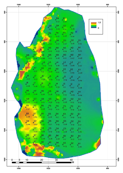
Figure 3. The relief of ice formation numbered 7 (color) and the location of the points of the topographic grid. Letters above the dots denote profiles from A to R. The numbers above points 1 to 8 show the position of the point within the profile. The numbers below the points are the height of the ice surface at a point in meters in the local system of coordinates. The relief was determined by topographic methods with an accuracy of 0.01 m in height and a horizontal resolution of 0.2 m. The icebreaker was located approximately along the right edge of the ice formation numbered 7.

![]()
Citation: Morozov P. A., A. I. Berkut, P. L. Vorovsky, F. P. Morozov, S. V. Pisarev (2021), Measuring sea ice thickness with the LOZA georadar, Russ. J. Earth Sci., 21, ES4003, doi:10.2205/2021ES000767.
Copyright 2021 by the Geophysical Center RAS.
Generated from LaTeX source by ELXfinal, v.2.0 software package.