RUSSIAN JOURNAL OF EARTH SCIENCES, VOL. 20, ES5003, doi:10.2205/2020ES000703, 2020
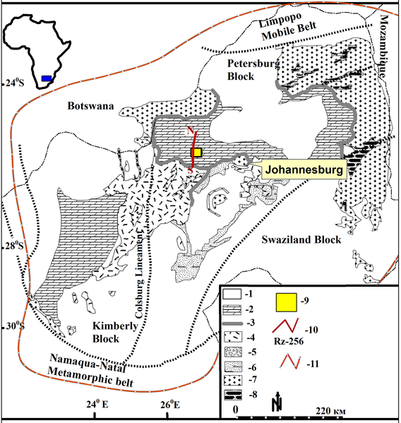
Figure 2. Geological map of the Kaapvaal Craton showing the distribution of surface and subsurface stratigraphic units (after Frimmel, 2014)]: 1 – Supracrustal intrusions (Pr1); 2 – Neoarchean manganiferous dolostones (Ar$_2$); 3 – Quartzite of the Black Reef Formation (Ar$_1$); 4 – Ventersdorp lava (Ar$_1$); 5 – Conglomerate, shale and subordinate sandstones of the upper Witwatersrand (Ar$_1$); 6 – Quartzites, shales and the subordinate conglomerate of the lower Witwatersrand (Ar$_1$); 7 – Archean granitoids (Ar$_1$); 8 – Archean greenstones (Ar$_1$); 9 – Study area; 10 – Seismic profile running through the study; 11 – Inferred extension of the Kaapvaal craton.

![]()
Citation: Pharoe Benedick Kinshasa, A. N. Evdokimov, I. M. Gembitskaya, Christopher Baiyegunhi, Zusakhe Nxantsiya (2020), Mineralogy, geochemistry and geological occurrence of supergene manganese ore mineralization in North West Province, South Africa, Russ. J. Earth Sci., 20, ES5003, doi:10.2205/2020ES000703.
Copyright 2020 by the Geophysical Center RAS.
Generated from LaTeX source by ELXfinal, v.2.0 software package.