RUSSIAN JOURNAL OF EARTH SCIENCES, VOL. 19, ES6005, doi:10.2205/2019ES000691, 2019
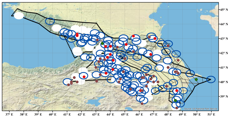
Figure 1. Scheme of morphostructural zoning (thick lines – lineaments of the I rank, medium – II rank, thin – III rank, solid lines – longitudinal lineaments, dashed – transverse lineaments [Soloviev et al., 2013]), earthquake-prone zones with $M \geq 6.0$ (empty ellipses with blue borders – zones recognized by the "Barrier-3" algorithm, white ellipses – "Cora-3", white ellipses with blue borders – both algorithms) and the epicenters of crustal earthquakes with $M \geq 6.0$ occurred in the Caucasus (Table 1 and Table 3) before 1900 (brown circles), in 1900–1992 (red circles), and after 1992 (green circles).

![]()
Citation: Dzeboev B. A., A. A. Soloviev, B. V. Dzeranov, J. K. Karapetyan, N. A. Sergeeva (2019), Strong earthquake-prone areas recognition based on the algorithm with a single pure training class. II. Caucasus, $M \geq $ 6.0. Variable EPA method, Russ. J. Earth Sci., 19, ES6005, doi:10.2205/2019ES000691.
Copyright 2019 by the Geophysical Center RAS.
Generated from LaTeX source by ELXfinal, v.2.0 software package.