Russian Journal of Earth Sciences
Vol. 6, No. 4, August 2004
Activity of Elbrus Volcano (North Caucasus)
A. G. Gurbanov1, A. L. Sobisevich2, L. E. Sobisevich2,
Yu. N. Nechaev2, V. N. Arbuzkin3,
N. I. Prutskii3, E. A. Trofimenko3, I. I. Grekov3
1 Institute of Geology of Ore Deposits, Petrography, Mineralogy,
and Geochemistry, Russian Academy of Sciences, Moscow;
2 Institute of Physics of the Earth, Russian Academy of Sciences,
Moscow
3 Federal Caucasus Geological Survey
Contents
Abstract
This paper summarizes the results of the work done by Russian geoscientists in the
area
of Elbrus volcanic center from the end of the XX to the beginning of the XXI century.
It is shown that the
results of the geological and geophysical studies of the Elbrus Volcano, including
the dating of its historic
eruptions, the anomalous velocities of longitudinal waves, the regions of low resistivity,
poor tectonic
dislocations, the gravity and temperature anomalies, and the resonance specifics
of the igneous rocks
suggest that Elbrus is an active volcano underlain by molten igneous rocks. The geological
characteristics
obtained in this study for the geological structures in the Elbrus area can be used
for the mathematical
modeling of the wave processes induced in the layered rocks of this volcanic cone.
Introduction
At the end of the last century volcanologists began to pay more attention to the
comprehensive
study of the so-called "sleeping'' volcanoes which may become active unexpectedly.
As to the Russian
territory, an example of these volcanoes is the Akademii Nauk Volcano (Kamchatka)
located in the caldera
of the same name, where volcanic activity had terminated 28
 8 thousand years ago. However,
simultaneous volcanic eruptions began unexpectedly on 02.01.1996 at the Karymskii
volcano and in the
Karymskii Lake filling the caldera of the Akademii Nauk Volcano
[Fedotov, 1997].
As to the European part of Russia, Elbrus Volcano is believed to be potentially active
[Avdulov, 1962;
Avdulov and Koronovskii, 1993;
Garetovskaya et al., 1986;
Khitarov et al., 1984;
Krasnopevtseva, 1984;
Masurenkov, 1961, 1971].
8 thousand years ago. However,
simultaneous volcanic eruptions began unexpectedly on 02.01.1996 at the Karymskii
volcano and in the
Karymskii Lake filling the caldera of the Akademii Nauk Volcano
[Fedotov, 1997].
As to the European part of Russia, Elbrus Volcano is believed to be potentially active
[Avdulov, 1962;
Avdulov and Koronovskii, 1993;
Garetovskaya et al., 1986;
Khitarov et al., 1984;
Krasnopevtseva, 1984;
Masurenkov, 1961, 1971].

|
|
Figure 1
|
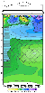
Elbrus Volcano (5643 m), the highest peak of Europe,
hangs over the densely populated North
Caucasus areas and the adjacent southern areas of Russia (Figure 1). The inference of its potential reactivation
calls
for reliable information on the existence of a magma chamber in this region, including
its size, the dynamic
specifics of its heterogeneous rocks, and the time of its last eruptions. The results
of theoretical studies and
the data of high-accuracy gravity and other geophysical measurements available open
up the prospects for
predicting the time and places of volcanic events in this area
[Rogozhin et al., 2001].
The modern morphological classifications of volcanoes are usually based on the view
that their
shapes are controlled by the composition of magma and by the mechanisms of their
volcanic eruptions. The
commonly used data are morphological characteristics of the volcano, such as the
absolute and relative
heights of its cone, or the elevation of its basement. The study of quantitative
relationships between these
characteristics and the composition of the volcanic rocks are useful for analyzing
the rising mechanism of
magma and for estimating the depth of its origin. Proceeding from the laws of hydrostatics,
the height of a
stratovolcano, which had reached its limiting value, can be treated as a value controlled
by the depth of the
magma chamber. Hence, an important conclusion can be derived that the basic magma
generated at a great
depth must produce higher volcanoes
[Masurenkov, 1972].
Elements of Tectonics and Lithosphere Structure
At the present time volcanoes are classified into two types. The first type includes
active
volcanoes of island arcs, most of which are not higher than 1500-2000 m. High
volcanoes are not numerous
there and can be ranked as basaltic or andesitic volcanoes (with SiO
2 contents of 49-59%)
[Fedotov et al., 1981].
The second type includes active volcanoes from young folded areas, which show the
proved
relationships between their heights and the compositions of the rocks composing them,
yet display the
general growth of their absolute heights and a great difference in the heights of
the volcanoes differing in
acidity. There are grounds to believe that the Elbrus Volcano also obeys the above
regularity.
Our theoretical studies suggested two mechanisms for the seismoacoustic sounding
of the magma
chamber: (1) the analysis of a microseismic background in the source area, where
the geoacoustic field may
include radiation at some typical frequencies, and (2) the analysis of waves
reflected from the wave source
(some induced wave-type processes) during its active sounding. The use of both methods
calls for the
preliminary study of the microseismic background in the source region, for the creation
of seismic
recording channels suitable, in terms of their amplitude and frequency characteristics,
to the problem at
hand, for their optimum dislocation in place, and for the development of effective
methods for seismic data
processing and analysis.

|
|
Figure 2
|
The first experiments associated with the study of the seismic
background in the region of the
magma chamber and the magma source of the Elbrus Volcano were made at the end of
the last century by a
group of geoscientists from the Russian Academy of Science, including N. I. Khitarov,
Yu. K. Shchukin, and A. V. Sizov
[Khitarov et al., 1984].
They measured the seismic background at the volcanic cone using a "Zemlya''-type
analog equipment. During their 5-day measurements they recorded a number of seismic
events which
included a group of them which differed radically, in terms of the recording types,
from the local
earthquakes recorded in the adjacent areas of the North Caucasus (Figure 2). The
most characteristic of the
recorded events were their lower than normal frequencies, namely 1-2 Hz, compared
to 5-6 Hz, usually
recorded in the area of the Elbrus volcanic center. Besides, the Elbrus seismic records
show small
magnitudes of shear waves and indistinct first arrivals even in the absence of noise.
These effects prove the
presence of a magma chamber.
The authors of the paper cited above believe that the magma chamber resides at a
small depth
below the Elbrus volcanic cone, this fact being proved "by the presence of an intensive
surface wave in all
records.'' They were unable to localize the source zone exactly. Nevertheless, they
concluded that "even the
data available suggest that with the low epicentral distance (10-15 km) the
seismic velocity anomaly
suggesting the existence of a zone of high seismic wave attenuation may exists under
Elbrus at a depth of
0.5-2 km below the sea level.''
Seismic observations in the Elbrus area were resumed with the onset of the operations
of a
complex international geological and geophysical expedition which included geoscientists
from the
Institute of Physics of the Earth, the Institute of Geology of Ore Deposits, Petrography,
Mineralogy and
Geochemistry, the Institute of Geosphere Dynamics, the Federal Caucasus Geological
Survey, and a
number of other organizations. In the course of this work the microseismic background
was recorded in the
area of the Elbrus volcanic edifice.
The first observation site was located in the Baksan R. ravine in the area of
the Moscow
University Geological Site located at the foot of the volcano. The absolute elevation
of the site is 2300 m,
its coordinates being 43o16' 09'' N
and 42o29' 14'' E.
The distance of this recording site from the Elbrus peak is 5.85 km.
The second observation site was located on the Terskol Peak, in the area of the Astrophysical
Observatory of the Ukrainian Academy of Science. The coordinates of this site were
43o16' 517'' N
and
42o29' 999'' E.
The absolute height of the site was 3100 m. The distance from this recording
site to the
Elbrus Peak was 5.6 km. The choice of the second alternative background recording
site was predetermined
by the fact that the Azau Glade showed an extremely high microseismic background.
The third observation site, where seismic background was recorded, was located in
the tunnel of
the Neitrino Observatory with the coordinates of 43o16' 338'' N
and
42o40' 878'' E,
the altitude of the site
being 1740 m, and its distance from the Elbrus Peak being 21.9 km. We begin
the description of the study
of the seismic environment in the Elbrus volcanic center with the results of recording
the microseismic
background.

|
|
Figure 3
|

|
|
Figure 4
|
Figures 3
and 4
show the characteristic velocity records of the microseismic noise (ten-second
samples) in the Elbrus region
[Sobisevich et al., 2001].
The upper figure shows the vertical wave
component, the intermediate, the horizontal component in the S-N direction, and the
lower, the horizontal
component in the W-E direction. Of particular interest is the observed low-frequency
modulation of the
seismic background.
Listed in Table 1
are the mean square values of velocity variations and displacements along all
constituents, calculated using 10-minute data samples. The analysis of the resulting
data suggests that all of
the oscillation constituents are roughly equal (see the data shown in Figure 2
[Khitarov et al., 1984]).
This phenomenon is characteristic of the microseismic background at the outcrops
of hard rocks.
As follows from Table 1, the microseismic oscillation level in the
area of the neutrino
measurement site is two orders of magnitude lower than that at the Azau Site and
an order of magnitude
lower than that at the Terskol Mt. peak. Characteristic of the spectra is the
presence of individual peaks.
Some peaks might be associated with the industrial noise from various mechanisms,
the other seem to be
associated with the presence of resonance features in the volcanic cone
[Sobisevich, 2001].
The results of our numerous experiments, carried out in the period of time from 1999
to 2002, suggest that
the use of modern geophysical instruments, especially, of deformation measurement
instruments, allows one
to record induced wave processes caused by igneous rock structures and other local
heterogeneities
[Sobisevich et al., 2001, 2002a].
The fine structure of the local heterogeneities in the area of the Elbrus volcanic
cone was studied
using a technology developed at the United Institute of the Earth's Physics
[Nechaev, 1999;
Nechaev and Sobisevich, 2000].
In accordance with the technology offered in these papers, the field of the tectonic
breaking of the Central Caucasus lithosphere was plotted using the results of processing
the photographs of
the ground surface, obtained from the "Resource'' Satellite. The first result of
this work was the map of a
lineament network for a territory measuring 185
 277 km with the Elbrus Volcano located
in its central part.
The subsequent processing of this map resulted in getting several maps varying from
1 to 50 km in depth,
where the values of tectonic shattering were calculated using a network of 1
1 km.
277 km with the Elbrus Volcano located
in its central part.
The subsequent processing of this map resulted in getting several maps varying from
1 to 50 km in depth,
where the values of tectonic shattering were calculated using a network of 1
1 km.

|
|
Figure 5
|
Let us see the specific features of this field for the upper
part of the Central Caucasus lithosphere,
using a section map for the average statistical depths of about 7 km (Figure 5)
[Nechaev and Sobisevich, 2000].
This horizontal section shows the slow growth of tectonic breaking from the southern
termination
of the epi-Hercynian Scythian Platform toward the region of the Central Caucasus
horst-anticlinorium and
its subsequent decrease toward the southern Greater Caucasus subsidence. The Laba-Malka
zone of the
highs is marked by the low values of this field ( < 80 arbitrary units), whereas its western area (gently monoclinal
Mesozoic sediments) shows higher values (70-90 arbitrary units), as compared
to its eastern margin (involved in
the uplifting of the southern segment of the epi-Hercynian Scythian Platform). The
protrusions of the
Paleozoic basement show the high values of a tectonic breaking field (80-100 arbitrary
units). The Tyrnyauz
suture zone, composed of Paleozoic and Jurassic rocks, was mapped as a narrow transition
zone of elevated
horizontal gradients, its eastern segment (east of the Kuban River) being most distinct.
The inversion
anticlinorium of the Greater Caucasus core, composed of highly folded metamorphic
rocks of the Liass-Dogger
age (Central Caucasus Horst-Anticlinorium) is distinguished by the maximum values
of this field
(up to 120 and higher arbitrary units). They occur as individual blocks separated
by the areas of lower
values ( < 100 arbitrary units).
The more southern region of the synclinoria in the southern Greater Caucasus limb,
filled with
Malm and Cretaceous isoclinal folded flysch, is represented by the lower values of
the field (less than 110 arbitrary units)
in the form of individual local anomalies ( < 90 arbitrary units). The Abkhazia-Racha Step, located in
the south of the territory concerned and represented by the anticlinoria and steps
of the southern limb of the
Greater Caucasus (moderately folded nonflysch Mesozoic rocks), showed somewhat lower
values ( < 100 arbitrary units).

|
|
Figure 6
|
The lithospheric heterogeneities, potentially associated with
the magma chamber of the Elbrus
Volcano, were located by way of analyzing the vertical sections of the tectonic breaking
field (Figure 6).
Profile 3-3' has a general Caucasus strike and
extends along the Tyrnyauz suture zone across the Elbrus
Volcano. This profile shows that the Central Caucasus lithosphere consists of two
structural stages (with a
boundary between them being inferred at a depth of about 20 km); the lower stage
is inferred to be a
basaltic crust, its base being located at a depth of slightly greater than 50 km.
Considering the behavior of the nearly horizontal lithospheric interfaces in the
vicinity of the
Elbrus volcanic cone, worthy of mention is their regular rising, this fact suggesting
that this volcanic cone
is restricted to the region of the anomalous structure of the lithosphere. The upper
part of the basaltic crust
(about 20 km thick) in its central segment located under the Elbrus Volcano
showed anomalous values of
the tectonic breaking field. This suggests that:
(1) the Central Caucasus territory had been initially underlain by the basalt
crust of the same type,
which was close, in terms of its physical and mechanical properties, to its present-day
remnants of the pre-Paleozoic basement (blocks and slabs) located west and east of
the central
anomalous region;
(2) the central block had moved northward and up the section along the nearly
meridional crustal
faults, and the Transcaucasus transverse uplift was formed during the next stage
of the Central
Caucasus evolution, when an anomalous region embracing the deep layers of the lithosphere
began to form, as indicated by the rise of the Moho discontinuity;
(3) the almost ten-percent decline of the values of the tectonic disintegration
in this anomalous
region suggests that the physical and mechanical properties of the central block
(slab)
changed toward their lower values. This suggests the existence of an extension region
in the
Transcaucasus transverse uplift (in its western periphery) and implies that the local
region of
abnormally low tectonic fracturing can be interpreted as a potential magma source
for the
Elbrus Volcano.
The potential existence of a magma source chamber was used as a basis for locating
the Elbrus
magma chamber in the upper part of the crust. For this purpose an area, 30
30 km in size (with Elbrus
Volcano standing in its middle), was chosen for processing space photographs in greater
detail. As a result,
fields of tectonic breaking were obtained for the horizontal sections corresponding
to the average statistical
depths of 4, 3, 2, and 1 km.
The position of the Elbrus Volcano in these maps was determined using the lowest
values of the
tectonic disintegration field in the projection area of the magma chamber.
|
|
Figure 7
|
The analysis of the maps for different depths showed that
at a depth of about 4 km the Elbrus
volcanic chamber had a roughly isometric form (measuring 10
15 km), elongated in the northern direction
relative to the position of the crater. The horizontal section at a depth of about
3 km showed an
insignificant branch of a ENE direction, which is most extensive in the higher section
(2 km) and remains
the same at the next level (1 km). It is of interest to note that the volcanic
chamber of Elbrus is connected
with its parental magma source in the vertical section of the tectonic shattering
field extending along the
strike of the Caucasus Range (Figure 7). The Elbrus magma chamber, outlined by
a contour line of 90 arbitrary units,
resides in the area of the volcanic cone and has the following dimensions: its lower
limit is restricted to a depth of about 8 km, the western boundary of the chamber
is roughly vertical, the
eastern boundary is inclined eastward at an angle of about
40o; the magma chamber is as wide as 9 km at a
depth of about 5 km and diminishes slowly in the direction toward the ground
surface. According to our
data, the size of the chamber diminishes greatly at a depth of about 2 km, where
it is not larger than 5 km,
its size being 2-2.5 km at a depth of 1 km.
The magma chamber of the Elbrus Volcano is restricted to the western periphery of
the magma
source residing at a distance of 10-12 km above it. It appears that magma flows
from its source to the
magma chamber along tectonically shattered zones.

|
|
Figure 8
|
The values of the tectonic shattering of the lithosphere confirm
the presence of a weak zone of this
kind (in the region of the western termination of the Trans-Caucasus transverse uplift).
The latter is
traceable in the depth interval of 45 to 12 km and is expressed by an abrupt
change in the behavior of the
field contour lines (growing more vertical) and in the almost invariable field values
(90-92 arbitrary units).
This field pattern allows one to trace the potential route of magma flow into the
chamber (shaded region in Figure 8)
[Bogatikov et al., 2002].
The above-mentioned igneous rock structures of the Elbrus Volcano are specific formations
in
terms of geophysics. For instance, magma formation results in the abrupt decline
of the viscosity of the
rock material in the melting region and, usually, in the decline of its density,
as well as in the changes of
some other geophysical parameters. These changes, in turn, lead to the rearrangement
of the internal
structure of the region and to the formation of objects with clearly expressed resonance
peculiarities which
manifest themselves in the modes of lithospheric deformations and induced seismic
fields.
We studied the spectra of the lithospheric deformation modes
in the area of the Elbrus Volcano
using the analytical results obtained by a group of researchers headed by V. K. Milyukov
(Shternberg
Institute of Astronomy, Moscow State University), who were engaged for many years
in the systematic
measurements using the Baksan laser interferometer-deformograph. The objects of these
studies were the
lithospheric deformations caused by high seismic events (earthquakes) of fairly large
magnitudes
(Mmax 6.0-7.0 and higher)
[Sobisevich et al., 2001, 2002a].
Figure 8
presents a series of relative deformations observed for individual earthquakes.
6.0-7.0 and higher)
[Sobisevich et al., 2001, 2002a].
Figure 8
presents a series of relative deformations observed for individual earthquakes.
We found that some modes in the region of extremely low frequencies
could be identified with the
high-frequency modes of the Earth's natural oscillations. This analysis allowed us
to identify the
characteristic modes induced during all earthquakes considered, unrelated to the
Earth's natural
oscillations. To be convinced in this fact the reader is referred to Table 2 which
gives the parameters of the
modes recorded during at least three of the earthquakes observed.

|
|
Figure 9
|
Similar data were obtained for 38 earthquakes
(see the paper by Sobisevich et al. [2002b]).
The interpretation of the experimental data in terms of the existing theoretical
model of a magma source and of the magma chamber of the Elbrus Volcano, with due
consideration of the
real dynamic processes operating under the external and internal effects, allowed
us to detect some
characteristic resonances of the magmatic rocks of this type. As an example, Figure 9 presents
the resulting
spectrum of the intrinsic resonance modes of the Elbrus volcanic rocks.

|
|
Figure 10
|
These results were confirmed in 2002 after the geological and geophysical investigations
along the
Elbrus profile were completed, this work having been ordered by the Department of
Natural Resources of
Russia (Table 3).
The work done in the framework of this project included the study of the structural
features of the
sedimentary cover and the Hercynian basement, the topography of deep crustal boundaries,
the vertical and
lateral heterogeneities in the crust and upper mantle, and the geophysical charateristics
of crustal faults and fracture zones
[Arbuzkin et al., 2002].
This profile, 192 km long, crossed the territories of the Kabardino-Balkarian
(~50 km) and Karachaevo-Cherkessian (~19 km) Republics and also the areas
of the Predgornyi,
Mineralnye Vody, and Aleksandrov regions of the Stavropol Territory (~123 km).
This work provided new
geological and geophysical data which were used to derive models along the profile
line both for the upper

|
|
Figure 11
|
part of the rock sequence and for the entire thickness of the Earth's crust (see
Figures 10
and 11).
The experimental results obtained showed that the geoelectric properties of the upper
part of the
rock sequence were highly variable. The most conductive rocks were recorded under
the northern half of
the profile, namely, in the Scythian Plate, where the most conductive rocks are the
Maikopian deposits. The
numerous wells drilled there showed the resistivities of 1-2 and even 0.5-0.6
W m. The total
conductivity of the Maikopian and overlying rocks was found to be as high as 1500 S
in the Terek-Kuma
Trough.
The results of the quantitative interpretation of the frequency sounding and induced
polarization
data showed that the deposits overlying the Maikopian rocks included 6 or 7 layers
of different (mainly
low) resistivity. In some areas their correlation was violated by the presence of
subvertical shatter zones.
The sedimentary rocks of the mountainous areas are usually poorly conductive. In
the south of the
North Caucasus Monocline the sedimentary cover consists of Cretaceous terrigenous-carbonate
deposits and Upper Jurassic-Early Cretaceous terrigenous rocks. Its total longitudinal
conductivity is not
higher than 10-15 S. As follows from the quantitative interpretation of the
resistivity data, the thickness of
the sediments there does not exceed 400-450 m, declining to 150 m in the
Podkumok R. Valley.
Southward, in the Laba-Malka zone, the Lower Jurassic deposits (sandstone, siltstone,
and argillite) are
poorly conductive. They have a maximum thickness in the immediate vicinity of the
Peredovoi Range in
the Mara Basin (up to 500 m), which declines abruptly to 50-150 m in the
area of the Malka Uplift,
emphasizing the tectonic contact between these and other structural features of the
Hercynian basement.
The sedimentary rocks of the Central Caucasus region are also characterized by shatter
zones of
varying intensity, which are most abundant in the Mineralnye Vody Protrusion. The
results of gravity
modeling admit the presence of the igneous rocks of the Mara volcanoplutonic rock
complex at the base of
the sedimentary cover at the northern flank of the Malka Rise. The Hercynian basement
along the profile
line is heterogeneous in resistivity, though shows less contrasting resistivity values
as compared to the
sedimentary rocks.
A more complex resistivity distribution pattern was found in the Central Caucasus
tectonic block
(to an absolute elevation of
- 5 km). It emphasizes the synclinal character of the Khasaut tectonically
layered zone complicated by subvertical faults and grabens between them.
The southern fault corresponds to the Sredinnyi magmatically active fault which can
be traced,
outside of the profile, by the centers of the Mara Early to Middle Jurassic volcano-plutonic
rocks.
Along the line of the profile this fault is accompanied by a vertical high-resistivity
body which is
interpreted as a diorite intrusion of Jurassic age.
Also clearly seen is the breaking of the pre-Jurassic basement in the Kislovodsk
anticlinal zone, in
the area where the sedimentary cover includes the rocks of the Mara Complex. Not
less broken are the
granitoids of the Malka igneous rock complex in the Bechasy anticlinal zone. The
central part of the Malka
Massif includes high-conductivity zones with resistivities which are not typical
of igneous rocks.
The Shaukamnysyrt fold zone and the Peredovoi Range graben (synclinorium), both located
more
to the south, occur as a high-resistivity block residing roughly 1 km below
the ground surface. The
probability of the unity of these tectonic elements has been suggested earlier by
G. I. Baranov and
I. I. Grekov who inferred the rocks of the Shaukamnysyrt Series under the
tectonic zone of the Peredovoi
Range. This suggests the greater role of the faults restricting the high-resistivity
block. The southern of
these faults corresponds to the Pshekish-Tyrnyauz fault zone, the northern, to the
not less significant Upper
Malka fault. The so-called Northern fault does not continue into the continental
crust and is ranked as a
near-surface one.
The interpretation of the results of the magnetotelluric sounding, performed at the
Elbrus slopes
and in its close vicinity revealed the following structure of the consolidated crust.
The volcanic rocks
showed high resistivity values ( > 1000
W m). The exceptions are the sites located
in the water-saturated
lake deposits, which lowered the resistivity to 20-30
W m in the upper part of the rock
sequence.
The crystalline basement of the Elbrus foundation is composed of the Proterozoic
rocks of the
Makera and Gondara complexes and Paleozoic granites which show rather high resistivities
(hundreds to
thousands
W m). Resistivivity declines to 40
W m and less in a depth interval of 5-10 km.
This resistivity decline agrees with the universally known fact that as temperature
grows to the
values of 400o-1000o C, the resistivity of the rocks declines
by a few orders of magnitude
[Lebedev and Shanets, 1986].
This and the fact that the temperature difference between the walls and the centers
of the peripheral sources
of andesite-dacite magma of the Kamchatka stratovolcanoes with their radii measuring
3.0-3.5 km is
about 1000o C [Fedotov, 1980],
suggest that the low-resistivity body discovered at a depth of 5-10 km under
the Elbrus Volcano is a magma chamber. The indirect evidence of a low-density body
located at a depth of
5-10 km under Elbrus is provided by the interpretation of a negative gravity
anomaly under Elbrus. Its
magnitude and gradients can be estimated reliably by introducing a body with density
of 2.37 g cm-3 with its
upper edge at a depth of
- 5 km and a thickness of about 10 km. The rise of this low-resistivity
body to the
north explains the presence of the sources of the Neogene-Quaternary volcanism north
of the Peredovoi Range (Tash-Tebe and other sources).
Another low-resistivity anomaly has been found at a greater depth of the crust (25
to 55 km) north
of Elbrus. This anomaly, about 15 km wide, plunges steeply (up to
70o ) to the north. Its contour coincides
closely with the contour of a low-velocity region, located using the method of reflected
earthquake waves,
where the velocities of longitudinal waves are abnormally low, as follows from tomographic
data. Taking
into account that the upper conductivity anomaly is also accompanied by the anomaly
of the low velocities
of longitudinal waves, this anomalous region can be interpreted as a deep-seated
magma source. The high
conductivity and low velocity of this magma body suggest its high temperature.
Conclusions
The results of our geological and geophysical investigations, carried out in the
Elbrus region, can
be summarized as follows:
(1) Our interdisciplinary experiments proved the presence of a magma
chamber in the Elbrus volcanic center. The results of the experimental measurements
of the
wave processes in the vicinity of a magma chamber, evolving under
the active external effects, are in good agreement with the theoretical data.
(2) The potential reactivation of the Elbrus Volcano, predicted by some investigators,
calls for
special investigations aimed to study the structure of the cone of this stratovolcano,
including
the exact location and monitoring of magma chambers in the Elbrus volcanic area.
(3) The final purpose of studying the Elbrus geological structure is to predict
the areas of the
potential lava flow by way of locating faults both on the open slopes and on the
slopes
covered by snow and ice. This can be done using a high-accuracy magnetic survey and
magnetotelluric measurements with the subsequent geological study of the located
heterogeneities of the physical fields.
(4) The existence of a direct relationship between the conductivity of the rocks
and their
temperature allows us to recommend the monitoring of the conductivity of the upper
and
lower conductors using magnetotelluric soundings twice a year at two to four sites
(in the
north and south of Elbrus) for the purpose of predicting the reactivation of these
volcanic
centers.
Acknowledgments
This work was supported by Program 13 of the Presidium of the Russian Academy of
Sciences
(Project 1.4), by the Russian Foundation for Basic Research (grant nos. 02-02-16100,
02-05-64939, 03-05-64215,
03-05-96744, and 03-05-64020), and by the CRD Foundation (Project RG1-2239).
References
Avdulov, M. V. (1962), The geological nature of the Elbrus gravity anomaly, Izv.
AN SSSR, Ser. Geol., (9), 67-74.
Avdulov, M. V. (1963), Crustal structure of the Central Caucasus region from gravity
data, Sov. Geology,
(9), 73-89.
Avdulov, M. V., and N. V. Koronovskii (1993), The geological nature of the Elbrus
gravity low, Moscow University Bulletin, Ser. Geol., 4(3), 32-39.
Andreev, B. A., and I. G. Klushin (1962), Geological Interpretation of Gravity
Anomalies,
120 pp., Gostoptekhizdat, Leningrad.
Arbuzkin, V. N., M. A. Kompaniets, A. I. Shvets, et al. (2002), Report
of a Geological and Geophysical Survey along the Elbrus Profile, 120 pp.,
Caucasus Geol. Survey, Essentuki.
Baranov, G. I., A. A. Belov, and S. M. Dotduev (1990), The Greater Caucasus,
in Tectonic Layering of the Lithosphere and Regional Geological Studies,
pp. 196-204, Moscow.
Bogatikov, O. A., A. G. Gurbanov, I. V. Melekestsev, et al. (1998), Potential
reactivation of Elbrus
volcano (North Caucasus) and its possible consequences, in Global Changes in
the Natural Environment,
pp. 153-164, Siberian Division of the Russian Academy of Sciences, Novosibirsk.
Bogatikov, O. A., Yu. V. Nechaev, and A. L. Sobisevich (2002), The use
of space technology to monitor
the geology of the Elbrus Volcano, Dokl. Russ. Akad. Nauk, 387(3), 244-247.
Dubinskii, A. Ya., N. A. Matsenko, Yu. Ya. Potapenko, and K. O. Rostovtsev
(1976), Schematic Geological Map of the North Caucasus and Adjacent Regions,
Scale 1:500 000, Moscow.
Fedotov, S. A. (1980), Initial temperatures of igneous rocks and the sizes and evolution
of magma
chambers in volcanoes, Volcanology and Seismology, (4), 3-29.
Fedotov, S. A. (1997), About eruptions in Academy Nauk caldera and Karymsky Volcano
at Kamchatka in 1996 year,
its investigation and mechanism), Vulkanol., Seismol., (5), 3-37.
Garetovskaya, I. V., G. V. Krasnopevtseva, F. V. Sizov, et al. (1986),
The study of the crustal structure of
the North Caucasus seismic zone using seismic and gravity methods, in Basic Problems
of Seismotectonics, pp. 105-119, Nauka, Moscow.
Godzikovskaya, A. A. (1977), Mantle earthquakes in the Caucasus region, in The
Modern Geodynamics and Deep Structure of the USSR Territory, pp. 106-110,
Nauka, Moscow.
Grekov, I. I., and N. I. Prutskii (2001), Problems of Geodynamics and Metallogeny
in the North Caucasus Region during its Late Hercynean-Triassic Evolution, pp. 4-16,
Nabla, Novocherkassk.
Grekov, I. I., and N. I. Prutskii (2000), Problems of tectonics and metallogeny in
the North Caucasus
region, in The Geology and Mineral Deposits of the North Caucasus, pp. 208-226,
Essentuki.
Khitarov, N. I., Yu. K. Shchukin and A. V. Sizov (1984), Estimation of
the Elbrus activity,
Doklady AN SSSR, 275(4), 952-984.
Kovalev, G. N., and Yu. P. Masurenkov (1971), The present-day state of the Elbrus
Volcano, Izv. AN SSSR, Ser. geology, (2), 25-29.
Krasnopevtseva, G. V. (1984), The Deep Structure of the Caucasus Seismically
Active Region, 178 pp.,
Nauka, Moscow.
Krasnopevtseva, G. V., and I. A. Rezanov (1970), The crustal structure of the Great
Caucasus central
segment, Izv. AN SSSR, Ser. Geol. (1), 12-19.
Laverov, N. P. (Ed.) (2002), Catastrophic Processes and Their Effects on the
Environment, Volcanism,
vol. 1, 409 pp., ROOU PPG, Moscow.
Lebedev, T. S., and S. M. Shanets (1986), Electrical properties of water-saturated
rocks in varying
temperature and pressure conditions, Geofizicheskiy Zhurnal, 8(3), 34-42.
Masurenkov, Yu. P. (1961), Tectonics, igneous activity, and carbonate mineral water
in the Elbrus area,
Izv. AN SSSR, Ser. Geol., (5), 45-57.
Masurenkov, Yu. P. (1971), Density of the thermal flow and depth of magma chamber
position under Elbrus Volcano,
Bull. Volcanol. Stations, (47), 79-82.
Masurenkov, Yu. P. (1972), Inclusions in modern volcanites of Kamchatka and problem
of magma origin, in Earth Crust of Island Arc and Fareast Seas, pp. 19-23,
Nauka, Moscow.
Milanovskii, E. E., and N. V. Koronovskii (1973), Orogenic Volcanism and Tectonics
of the Alpine Belt of Eurasia, 267 pp., Nedra, Moscow.
Nechaev, Yu. V. (1999), The use of space technology in the study of the local heterogeneities
of the
Earth's crust, in The Collection of Papers "Geophysics Between the Two Centuries'',
pp. 276-290,
United Institute of the Physics of the Earth, Moscow.
Nechaev, Yu. V., and A. L. Sobisevich (2000), The use of space technology to solve
the problems of the
mechanical and mathematic modeling of the internal structure of a geophysical medium,
in Abstracts of Papers Presented at the 3d International Aerospace Congress,
IAC-2000, pp. 23-24, Moscow.
Nikolskii, Yu. I., T. A. Milai, and L. Z. Kogan (1975), Geological
and Geophysical Studies of the Caucasus Tectonics, Magmatism, and Metallogeny,
128 pp., Nedra, Leningrad.
Reznikov, V. I. (1997), A ring structural feature in the North Caucasus, in Problems
of the Geology and Geoecology in the Caucasus and Southern Russia, pp. 62-64,
Nabla, Novocherkassk.
Rogozhin, E. A., and L. E. Sobisevich (1996), Comparative geodynamics and seismotectonics
of the
Central, Northwestern, and Eastern Pontides, in Evolution of Methods and Technical
Means in Experimental Geophysics, Iss. 2, pp. 17-38, United Institute
of the Earth Physics, Moscow.
Smirnova, M. A. (1999), A tectonic and magmatic ring structure in the Mineralnye
Vody region, in
Tectonics, Geodynamics, Magmatism, and Metamorphism, vol. II, pp. 153-155,
Moscow.
Sobisevich, A. L. (2001), Monitoring of Layered Heterogeneous Rock Media,
a monograph, 354 pp.,
United Institute of the Earth Physics, Moscow.
Sobisevicv, L. E., and A. L. Sobisevich (2001), Wave Processes and Resonance
in Geophysics, 297 pp.,
United Institute of the Earth Physics, Moscow.
Sobisevich, L. E., Yu. V. Nechaev, A. L. Sobisevich, et al. (2001),
Monitoring of Igneous Rock Structures in Elbrus Volcano, edited by N. P. Laverov,
192 pp., United Institute of the Earth Physics, Moscow.
Sobisevich, L. E., V. K. Milyukov, and A. L. Sobisevich (2002a), Mechanical
and Mathematical Monitoring of Elbrus Igneous Rock Structures, pp. 223-249,
United Institute of the Earth Physics, Moscow.
Sobisevich, L. E., O. V. Rudenko, V. K. Milyukov, and Yu. V. Nechaev
(2002b), Monitoring of induced geophysical processes
in heterogenic rocks of central-type of volcanos, in: Catastrophic Processes
and Their Effects on the Environment, Volcanism, edited by N. P. Laverov,
vol. 1, chapter 4, pp. 365-398.
Load files for printing and local use.
This document was generated by TeXWeb
(Win32, v.1.3) on October 22, 2004.