A. F. Grachev
United Institute of Physics of the Earth, Russian Academy of Sciences, Moscow
|
"Tuynianov used to tell, that there are investigations which
under the correct study lead to wrong results and
there are such ones which under the invalid
observations lead to proper results'' [L.Ginzburg, 2002, p. 12]. |
Since the appearance of plate tectonics the question of a number of plates came to be regarded as the most important and widely debated topics among geologists [Le Pichon et al., 1972; Plate tectonics, 1972; and many others]. In the discussion that follows a number of plates will be enhanced markedly as a result of delineation of so called minor plates (microplates, platelets), although in most cases they represent the simple intraplate lithosphere blocks (for instance, within the Eurasian lithospheric plate the Amur, Okhotsk, China and other microplates have been established [Zonenshain and Savostin, 1979]).
It must be emphasized that in some papers continental rifts are regarded as a divergent or constructive plate boundaries [Zonenshain and Savostin, 1979; and others]. This is contradictory to basic principles of plate tectonics. The earth's crust keeps all characteristics beneath the continental rifts, the only change is a decrease of thickness as a result of extension. Actually, as Le Pichon et al. [1973] pointed out, continental rifts are the intraplate structures rather than constructive plate boundaries.
At present we recognize three types of junction between the Mid-Oceanic Ridges and continents. The first case refers to the western North America where the East Pacific Rise goes to the Gorda and Juan de Fuca Mid-Oceanic Ridges through the San-Andreas transform fault. The second one includes the triple junction structure in Afar, Ethiophia, where the Sheba Ridge (the extension of the Mid-Oceanic Carlsberg Ridge) links with the Main Ethiopian Rift and the spreading axis of the Red Sea. And at last the third case includes the Mid-Arctic Gakkel Ridge that has an edge joint with the Laptev Sea continental margin and together with the Moma rift all these units form the Arctic rift system.
One of the postulates of plate tectonics says that all lithospheric plates must be encircled by some closed curve on the Earth's surface. Because the Mid-Arctic Gakkel Ridge marks the boundary between the Eurasian and North American plates, the question how the plate boundary goes to the south from the Gakkel Ridge ending onto North-Eastern part of the Eurasian continent is by no means clear.
After discovery of the world system of the Mid-Oceanic Ridges at the end of 50's in the Atlantic, Pacific and Indian oceans, the existence of similar ridge in the Arctic ocean has not been known. In 1954 Ja. Ja. Gakkel Gakkel [1957] predicted the occurrence of submarine ridge in the Eurasian basin on a basis of a rare set of bathymetric data, however only B. Heezen in 1961 could cite the exhaustive evidences that this ridge really exited. He also proposed that Pri-Verkhoyansk foredeep was a continental extension of the Gakkel Ridge [Heezen and Ewing, 1961).
Independent from above mentioned authors A. F. Grachev concluded that the Moma trough in Chersky mountain system is the most probable continuation of the boundary between the Eurasian and North American lithospheric plates. Later the special field studies confirmed the rift nature of the Moma trough and allowed the Moma rift zone to be distinguished [Grachev, 1973, 1977; Grachev et al., 1970]. The latter, together with the Gakkel Ridge and Laptev Sea passive margin form the Arctic Rift System (ARS).
Such a point of view was widely appraised in geological and geophysical literature [Avetisov, 1993; Chapman and Solomon, 1976; Conant, 1973; Cook et al., 1987; Fujita et al., 1990a, 1990b; Gramberg et al., 1990; Minster et al., 1974; Pitman and Talwani, 1972; Zonenshein and Savostin, 1979; and many others].
The Gakkel Ridge is situated in the Eurasian basin of the Arctic ocean and represents the direct extension of the system of the Mid-Oceanic ridges in the North Atlantic and Norway-Greenland basin through the Mona and Knipovich Ridges. It divides the Eurasian basin into two equal parts and its coincidence with the median line is better than in the other known ridges [Grachev and Naryshkin, 1978]. This ridge is the world's slowest spreading mid-ocean ridge with spreading rates ranging from 1.2 cm/year to 0.6 cm/year in the southernmost part close to the Laptev Sea.
|
|
| Figure 1 |
|
| Figure 2 |

|
| Figure 3 |
Based on the study of magnetic lineations in the Eurasian basin Karasik [1974] and Vogt et al. [1979, 1981] calculated that rates of spreading of 0.5, 0.32, 0.30-0.59 cm/yr for the time intervals bounded by 0, 10, 20, 38-51 m.y. before present. Near the Laptev Sea the magnetic field intensity falls and its structure becomes more simple. Due to the anomaly confluence, the number of magnetic anomalies decreases from 47 to 6 [Karasik, 1980; Kovacs, 1983] (Figure 2). At the southern end of the Gakkel Ridge the magnetic field pattern is characterized by an absence of a polarity difference. Thus all signs of the ocean-spreading magnetic field disappeared at this place [Rzhevsky, 1975] (Figure 3). The spreading rate decreases from 0.6-0.7 cm/yr in the central Garrel Ridge to 0.3 cm/yr in the southernmost part [Grachev and Karasik, 1974]. The latter value is the lowest rate known for the world system of spreading ridges. In the Laptev Sea separation velocity must be about 0.1 cm/yr.
Thus, sea-floor spreading on the southern ending of the Gakkel Ridge is followed by extension of the continental crust, resulting in crustal thinning. The single deep seismic sounding along the profile from the Lena river mouth to the Yana mouth through the northern tip of Buor-Haya cape proved the thinning of continental crust and the existence the low velocity mantle ( Vp 7.5 km/s) beneath the basaltic layer of thickness about 20 km [Kogan, 1974].
It is important to note that there are no islands on the Gakkel Ridge that is a consequence of a low rate of spreading and volcanic activity. There are also no islands within the Gorda, Juan-de-Fuca and Explorer ridges. The first data of chemistry of volcanic rocks have been obtained recently during the ARCTIC '91 expedition aboard RV Polarstern to the Central Arctic Ocean [Muhe et al., 1993, 1997]. The rocks (volcanic glasses) recovered from the southern slope of the rift valley are relatively unfractionated primitive basalts with E-MORB trace element compositions of early Quaternary age.
It is interesting to note in this connection the first evidence of a high hydrothermal activity in the southern termination of the Gakkel Ridge (77oN, 125o E). Here in the core sample the remnants of bivalavia Arcivesica sp. nova of the Vesicomyidae family have been found [Kim et al., 1997]. Such fauna is typical for hydrothermal venting on the Mid-Oceanic Ridges.
Having all signs of the Mid-Oceanic Ridges, the Gakkel Ridge has one of the slowest spreading rates of all mid-oceanic ridges that are responsible for the many features of topography and structure. The last results of geophysical investigations confirm this conclusion [Coakley and Cochran, 1998; Weigelt and Jokat, 2001]. Gravity studies estimate a crustal thickness between 1 and 4 km for the Gakkel Ridge [Coakley and Cochran, 1998], much lower than the canonical 6-7-km crust observed beneath the remainder of the Earth's oceans. Such thin crust under axial zone suggests the low magma supply, low heat flow as a result of the block structure of axial zone of the ridge with very deep rift valley more then 5000 m depth.
However the most important and distinctive feature of the Gakkel Ridge consists of the butt junction with the Laptev sea passive continental margin [Grachev, 1982; Grachev and Karasik, 1974; Karasik and Grachev, 1977]. Such a type of a junction has never been observed in other known cases, where the spreading axis is parallel to passive continental margin.

|
| Figure 4 |
|
| Figure 5 |

|
| Figure 6 |

|
| Figure 7 |
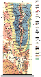
The northernmost isolines within the Laptev Sea floor outline the continental slope and directly join it. To the south it goes into a subsidence area, where pericline of the Taimyr and Novosibirskaya uplifts are situated to the east and the west. Southward there are the South-Laptev and Ust'-Yana uplifts. A zone of northwest movements, represented by a system of linear depressions assigned to the Ust'-Lena subsidence zone, occurs against this background. The northwest end can be traced toward the continental slope, and at 76oN and 124oE it joins the northeast striking subsidence zone (a part of the continental slope structure) where the buried extension of the Gakkel Ridge is determined by gravity data and trend analysis of bottom topography (Figure 1).
Thus, the zone of the most distinct tectonic movements of the Laptev Sea is an extension of the Eurasian basin structure. These movements are characterized by the same axis of symmetry. We can obtain approximate outlines of neotectonic and recent crustal movements in this zone if we project southward the boundaries of the Eurasian continental slope.
More valid evidence supporting the structural position of this zone is obtained by defining a pole of rotation with respect to the opening of the Eurasian basin. Its coordinates (72oN and 129oE) determined by Karasik [1980] allow to locate the above mentioned zone in this sector. The most part of earthquakes are concentrated within this zone (see below).

|
| Figure 8 |

|
| Figure 9 |

|
| Figure 10 |

|
| Figure 11 |
|
| Figure 12 |

|
| Figure 13 |
The Moma rift is situated within the Mesozoic folded belt of the Chersky ridge and stretches in the northwest direction from the Seimchan-Byiandyn depression in the south to the Laptev Sea in the north within distance of 1200 km [Grachev, 1973, 1982, 2000]. The Moma rift has developed within the Mesozoic fold belt in North-East Asia. The neotectonic structure of the rift is highly inherited from Mesozoic folded basement in the southeast and superimposed in the north-west in the Polousny Range where the Quaternary fault system stretches into a tension structure of the Laptev Sea floor.

|
| Figure 14 |

|
| Figure 15 |
At first we must note that the stratigraphy of the subaerial Cenozoic sediments of the North-East Asia is based mainly on the palinological analysis and the correlation of the sections based on the pollen study is very complicated due the existence of the rewashed pollen. In my first papers published at the very beginning of 70s and based of a detailed comparative study of stratigraphy, lithology and facial analysis of Cenozoic sediments two stages were recognized in the history of the development of the Moma rift [Grachev, 1973; Grachev et al., 1967, 1970]. The first (Pliocene to Early Quaternary) is characterized by a deposition of thick, well sorted alluvial-lacustrine sediments. The latter started to develop after cessation of the orogenic movements at the end of Cretaceous. Paleomagnetic investigations and paleogeographic reconstructions have proved that tectonic movements in the north-eastern margin of the Asian continent continued between Late Cretaceous times and 53-50 Ma due of a collision of microcontinents (Kolyma-Omolon and Chukotka, respectively) and long-lasting existing convergent margins of Siberian craton [Oxman, 2003; Parfenov, 1984; Yo-ichiro et al., 2003]. Coarse clastics (molasses) of the Mid-Quaternary age resting with angular unconformity on the lower unit were deposited owing to the growth of mountain ridges during the second stage. Another evidence of the time span of the Moma Rift formation can be obtained by the study of the recent drainage pattern development. As it was shown by Trushkov [1972], Baranova and Biske [1964] and others the oldest dated terraces refer to the Upper Pliocene-Early Quaternary time. Thus, taking into account the insufficient thickness of molasse the mountain-building processes within the Moma Rift is in its very beginning in comparison with the mature continental rifts such as the Baikal rift and others [Grachev, 1987]. The nature of active faults of the Moma rift has been widely discussed in many papers. These faults have the NW-SE strike and their position is highly inherited from the Mesozoic structural pattern [Merzliakov, 1971]. The one exception is the north-western termination of the Moma rift where the mid-Quaternary West Polousny faults form the superimposed structure and cross-cut the Mesozoic basement.

|
| Figure 16 |
The first data on the active low angle faults along the western and eastern margin of the Verkhoyansk-Kolyma mountains have the great importance for understanding the recent geodynamics. Such faults were described on the boundary the Verkhoyansk folded belt and the Siberian platform [Parfenov and Prokop'ev, 1993] and along the north-eastern part of the Moma ridge in junction with the Zyrianka basin [Gaiduk et al., 1988]. Because the planes of thrusts dip in opposite directions from the Verkhoyansk-Kolyma mountains there are two probable explanation. The first one assumes that the extension exists within the internal part of mountains and the second one proposes that they are the result of the gravity sliding (charriage cassant of E. Argaund). However the latter explanation is less likely for the lack of the high topography.

|
| Figure 17 |

|
| Figure 18 |

|
| Figure 19 |

|
| Figure 20 |
One more volcano, named the Bilibin Volcano after the noted geologist Yu. A. Bilibin, was discovered by Yu. M. Dovgal' in the same year in the left-hand bank area of the Bol'shoi Anyui River [Chasovitin, 1963]. Ichetovkin et al. [1970] report alkalic basaltoid exposures in the Verkhne-Kupkinskii and Nerkinskii depression filled with Neogene deposits. Basaltic dikes intrude Upper Cretaceous rhyolites and are overlain by Upper Quaternary glacial deposits; therefore, these basalts are likely to date at the Quaternary, although recent K-Ar isotope datings of volcanics in the Viliga River basin yielded an age of 11 to 13 Ma [Apt et al., 1997]. These estimates, as well as 40Ar/36Ar age determinations, should be regarded with caution because of the presence of excess argon. The young age of basalts, developed in the De Longa island group (Zhokhov and Vil'kitskii Islands) and dated previously at the Cretaceous [Geology..., 1970], has been established with certainty only recently, in the mid-1980s [Bogdanovskiiet et al., 1992]. Similar to the Priokhot'e basalts, K-Ar datings raise doubts because they indicate a radiometric age ranging from 0.4 to 6.1 Ma, which contradicts a very fresh habit of the rocks and absence of any data on interruption in volcanic activity [Geology..., 1970; Savostin et al., 1988]. It is also surprising that datings of limburgites from the Vil'kitskii Island yield ages ranging from 0.4 to 0.9 Ma, whereas the age range of the same rocks from the neighboring Zhokhov Island is 1.9 to 4.2 Ma. Thus, the problem of lava ages in the De-Longa archipelago remains open.
The morphology and age of these volcanoes, as well as the main petrographic
characteristics of extrusive lavas, are described in detail elsewhere
[Bazarova and Vavilov, 1989;
Bogdanovskii et al., 1993;
Dovgal' and Chasovitin, 1965;
Grachev, 1973;
Grachev et al., 1991, 1996, 1998a, 1998b;
Rudich, 1964;
Silant'ev et al., 1991;
Ustiev, 1961].
None of the volcanic features, except for basalts of the Zhokhov and Vil'kitskii
Volcanoes, are older than the Holocene
[Rudich and Ustiev, 1966;
Ustiev, 1961].
In several cases such as the Anyui and Balagan-Tas Volcanoes, eruptions are established
to occur in the historical time
[Grachev, 1973;
Ustiev, 1961].
As regards the rhyolitic Uraga-Khaya dome in the right-hand bank area of the
Moma River, 30 km northeast of the Balagan-Tas Volcano, its age is estimated
at the Middle
Miocene (16.2
 0.4 Ma according to K-Ar determinations on
biotite)
[Grachev, 1973],
although this structure was previously considered as a Quaternary volcanic feature.
0.4 Ma according to K-Ar determinations on
biotite)
[Grachev, 1973],
although this structure was previously considered as a Quaternary volcanic feature.

|
| Figure 21 |
Data on the modal composition of Holocene volcanic lavas reported by many authors [Bazarova and Vavilov, 1989; Dovgal' and Chasovitin, 1965; Grachev, 1973; Rudich, 1964; Savostin et al., 1988; Ustiev, 1961] provide poor constraints on the origin of magmatic activity. For this reason, I focus on specific features of the distribution of major, minor, and rare earth elements based mostly on new data. All of the studied volcanic rocks are subdivided into two series depending on their petrochemical characteristics.

|
| Figure 22 |
This conclusion is supported by long-term experience in the study of ultrabasic xenoliths
in basalts of the Baikal rift, China, Tien Shan, Spain, the Canary Islands, and other
regions. The
chemistry is generally characterized by a high bulk concentration of FeO
 nearly independent of
the MgO concentration, which varies from 6 to 20%, and a typically high alkalinity
of the rocks
(4 to 7.5%). Also characteristic is a higher phosphorus concentration (0.3 to 1.0%).
All of the
basalts, except those of the Anyui Volcano, have a high Ti concentration exceeding
2%.
Maximum TiO2 concentrations reach 3.81 and 4.79% in the Balagan-Tas and Priokhot'e
lavas,
respectively. Thus, the major petrochemical characteristic of all the studied basalts
in question is
their high Ti, Fe, and P concentrations, and they may be assigned to the Fe-Ti type
[Grachev, 1987, 1998b].
Comparison of their average compositions with those of the known continental
and mantle plumes (Table 3) shows that they are identical in these characteristics.
nearly independent of
the MgO concentration, which varies from 6 to 20%, and a typically high alkalinity
of the rocks
(4 to 7.5%). Also characteristic is a higher phosphorus concentration (0.3 to 1.0%).
All of the
basalts, except those of the Anyui Volcano, have a high Ti concentration exceeding
2%.
Maximum TiO2 concentrations reach 3.81 and 4.79% in the Balagan-Tas and Priokhot'e
lavas,
respectively. Thus, the major petrochemical characteristic of all the studied basalts
in question is
their high Ti, Fe, and P concentrations, and they may be assigned to the Fe-Ti type
[Grachev, 1987, 1998b].
Comparison of their average compositions with those of the known continental
and mantle plumes (Table 3) shows that they are identical in these characteristics.

|
| Figure 23 |

|
| Figure 24 |

|
| Figure 25 |
Thus, fractionation of olivine was the main process responsible for the formation of the volcanic rock series on the Zhokhov Island, and fractionation of pyroxene controlled the development of basanites and alkali basalts of the Balagan-Tas, Anyui, and Aluchin volcanoes.

|
| Figure 26 |

|
| Figure 27 |

|
| Figure 28 |
Here, I present new constraints on the He, Ar, Sr, and Ne isotope systematics in all of the studied areas of Quaternary volcanism in Northeast Asia. He isotopes were studied on bulk samples, which always yield underestimated values as compared with data from olivine phenocrysts or megacrysts [Drubetskoi and Grachev, 1987; Grachev et al., 1992]. Since these minerals are present in rocks as microlites, the inferred estimates of 3 He/ 4 He should be considered as a lower limit of this ratio.
Table 4 evidently indicates the ratio
3He/4He to range within wide limits: from ratios an
order of magnitude greater than the atmospheric value (1.39
 10-6 ) to those typical of mantle
plumes ( > 20
10-6 ). Ratios close to or smaller than atmospheric values are observed
in lavas of
the Zhokhov Island and Pyatistennyi and Aluchin volcanoes. The Balagan-Tas Volcano
basalts
yield a
3He/4He value a few times greater than the atmospheric ratio, and the greatest
values,
close to the mantle plume ratios, are noted in lavas of the Anyui Volcano. Comparison
of helium
isotope ratios in Quaternary lavas of Northeast Asia volcanoes with areas of typical
mantle
plumes shows that they are also characterized by high variations in
3He/4He, with deviations as
large as an order of magnitude or more. The presence of samples with
3He/4He exceeding the
typical value of mid-ocean ridge basalts (MORB) (in a sense, a constant) is evidence
of a plume-type source.
10-6 ) to those typical of mantle
plumes ( > 20
10-6 ). Ratios close to or smaller than atmospheric values are observed
in lavas of
the Zhokhov Island and Pyatistennyi and Aluchin volcanoes. The Balagan-Tas Volcano
basalts
yield a
3He/4He value a few times greater than the atmospheric ratio, and the greatest
values,
close to the mantle plume ratios, are noted in lavas of the Anyui Volcano. Comparison
of helium
isotope ratios in Quaternary lavas of Northeast Asia volcanoes with areas of typical
mantle
plumes shows that they are also characterized by high variations in
3He/4He, with deviations as
large as an order of magnitude or more. The presence of samples with
3He/4He exceeding the
typical value of mid-ocean ridge basalts (MORB) (in a sense, a constant) is evidence
of a plume-type source.

|
| Figure 29 |
10-6,
40Ar/36Ar
> 10000
[Azbel' and Tolstikhin, 1988]).

|
| Figure 30 |

|
| Figure 31 |
Most figurative points on the 3He/4He-87Sr/86Sr diagram (Figure 31) lie, on the one hand, in the field of mantle plume compositions from Iceland and Ethiopia and, on the other hand, from the Pacific continental margin. He isotope compositions from mature island arcs (Kamchatka, Japan, and others) and from the South American active continental margin are largely controlled by mixing with recycled oceanic crust [Poreda and Craig, 1989]. Therefore, the observed 3He/4He variations in lavas from the Anyui and Balagan-Tas Volcanoes and partly from the Aluchin volcanoes are due to the mixing of matter from three sources: MORB, mantle plumes, and recycled oceanic crust. The latter circumstance results from the history of Northeast Asia development in the Mesozoic [Parfenov, 1984].
A main feature of the Late Quaternary volcanism in Northeast Asia is the fact that lavas which simultaneously erupted over a vast territory in various recent geodynamic environments are similar in many whole rock geochemical and isotopic characteristics that are typical of intraplate magmatism areas regardless of the crust type. This fact alone implies that their volcanic evolution is related to neither the geologic history of the region studied nor the structural features of their recent geodynamics.
The main structural elements of the folded basement of Northeast Asia had formed by the end of the Late Cretaceous, when both the subduction in the Okhotsk-Chukotka belt [Parfenov, 1984] and collision within the Cherskii Range stopped. Their further development is associated with the initial peneplenization and formation of the weathering crust which lasted until the Miocene, when the new, platform stage of development began over most of the territory of Northeast Asia. The present structure of this region formed as a result of neotectonic movements that started at the Pliocene-Early Quaternary [Neotectonics..., 1989]. The position of volcanic centers indicates that Quaternary volcanism developed in diverse regions, such as the present platform (De-Longa Islands), rifting zone (Balagan-Tas volcano), and orogenic zone (Anyui, Bilibin, and Aluchin volcanoes). Taking into account that the compositions of the volcanic rocks are similar in petrochemical, geochemical, and isotopic characteristics and are typical of Fe-Ti basalts, the absence of any relation of these rocks to tectonic regimes is evident. However, there is a circumstance that, in my opinion, is directly related to the localization of magmatic activity in the region considered; this is the proximity of Quaternary volcanic features to the boundary between the Eurasian and North American lithospheric plates.

|
| Figure 32 |
Notwithstanding the divergence in rotation pole determinations caused by both the accuracy of original data used at various times and differences in methods (magnetic anomalies, transform faults, and so on), the general tendency is the progressive southeastward motion of the pole with time (Figure 32). Karasik et al. [1984] distinguished four phases in the opening history of the Eurasian basin. Only the last of these, lasting from 4 Ma to the present, is most relevant to our analysis. During this phase, when the present structure of Northeast Asia formed, the opening pole moved south into the area with coordinates 59.5oN, 142.5o E-59.6oN, 144.5oE [Karasik et al., 1984], and one of the most important results of this kinematic rearrangement in movements of the Eurasian and North American plates was the development of the Moma continental rift [Grachev, 1973, 1982, 1996; Grachev et al., 1967, 1970], within which the Balagan-Tas Volcano is located. As is noted by Burke [1984, p. 161), "the active volcanism in the Balagan-Tas area is helpful in defining the rifting limits at this time (from 9 Ma to the present)''.
Thus, whereas the origin of the Balagan-Tas Volcano might have been related to processes at the destructive boundary between the Eurasian and North American plate boundaries, the other volcanism features remain unexplained in terms of the structural control of the volcanism. However, in light of the above data on magmatism, the recent geodynamics of Northeast Asia needs insight into the driving mechanism responsible for simultaneous point-like lava eruptions more than 1000 km apart rather than for the Balagan-Tas Volcano alone, as was done in my early works on the Moma rift.
As it is evident from the above bulk chemical analyses and data on geochemistry and isotopic composition of Quaternary lavas from Northeast Asia volcanoes, all of the volcanic rocks may be considered to have originated as a result of the melting of mantle plume material with weak contamination by lithospheric material. However, as distinct from the known mature plumes within the continental lithosphere, the geodynamic situation in Northeast Asia is probably unique in that we face here the very beginning of mantle plume origination, when columns of upwelling mantle material reach the base of the lithosphere. In this case, the volcanoes themselves may be regarded as potential triple junctions.
Such a model, when applied to the territory considered, not only adequately explains the present volcanism localization in Northeast Asia but also suggests the presence of still undiscovered (or future) magmatism features within an imaginary polygon defined by the known volcanoes. Possibly, the problematic volcanic feature in the Kedon River head area also belongs to this type if its Late Quaternary age is established.
On the other hand, many aspects of recent geodynamics in Northeast Asia can be naturally explained within the framework of the hypothesis offered. These are a complex and unsteady stress field; the southeastern Moma rift termination, topographically not expressed; and others. From the standpoint of plate tectonics, a breakup of continental lithosphere between the Eurasian and North American plates can occur only along a system of plumes, as was predicted by J. T. Wilson and as actually occurred in the past. Previously, I have noted that geodynamics of the Laptev Sea shelf zone, where the Mid-Ocean Gakkel Ridge advances into the Asian continent, may be called the pre-Afar stage [Grachev, 1982], and this makes the zone unique.
From the current state of lithospheric plate motions and plate boundary interactions [Henderson, 2001] the geodynamic situation in Northeast Asia does not fit into the accepted plate tectonics schemes. In the case under discussion we have a new type of plate boundaries that is not considered before. We propose that in Northeast Asia up to now there is an unknown type of the plate boundary induced by incipient mantle plume at the very beginning stage. All previous attempts to represent the boundary between the Eurasian and North American plates in linear form lose their meaning.
Akinin, V. V., and Yu. E. Apt, Enmelen Volcanoes, Chukotka Peninsula: Petrology of Alkali Lavas and Deep Inclusions, Magadan, 1994.
Albarede, F., How Deep Do Common Basaltic Magmas Form and Differentiate?, J. Geophys. Res., 97, 10997-11009, 1992.
Apt, Yu. E., V. V. Akinin, and J. E. Wright, Sr, Nd, and Pb Isotopes in Neogene Melanephelinite and Deep Xenoliths in Northeastern Russia, Petrologiya, (1), 1997.
Avetisov, G. P., Some problems of lithospheric dynamics of the Laptev Sea (in Russian), Fizika Zemli 5, 28-38, 1993.
Avetisov, G. P., Seismoactive Zones of the Arctic (in Russian), 185 pp., VNIIOkeanologiya, St. Petersburg, 1996.
Avetisov G. P., and V. S. Golubkov, Tectono-seismic zonation of the Arctic basin and adjacent regions, in Geology and mineral resources of the northern Siberian platform, Trudy, (8), 25-30, Nauchno-Issledovatel'skiy Institut Geologii Arktiki, Leningrad, 1971.
Azbel', I. Ya., and I. N. Tolstikhin, Radiogenic Isotopes and Evolution of the Earth's Mantle, Crust, and Atmosphere, Apatity, 1988.
Baranova, Yu. P., and S. F. Biske, Cenozoic evolution of the northeastern USSR, (in Russian), Nauka, Moscow, 1964.
Barazangi, M., and J. Dorman, Seismicity map of the Arctic compiled from ESSA Coast and Geodetic Survey, Epicenter data, 1961-1967, Seism. Soc. Amer. Bull., 59, (1), 369-380, 1969.
Bazarova, T. Yu., and M. A. Vavilov, Physicochemical Conditions of Crystallization of Anyui Volcano Basalts, Geol. Geofiz., (2), 46-50, 1989.
Belyi, V. F., Ultrabasic Alkalic Volcanism of the Bering Volcanic Province, Chukotka, Tikhookean. Geol., (5), 65-77, 1998.
Bidjiev, R. A., and L. M. Natapov, On the occurrences of Cenozoic folding in Verkhoijanie (in Russian), Reports of the Acad. Sci. USSR, 205, 411-413, 1972.
Bogdanovskii, O. G., S. D. Mineev, S. S. Assonov, et al., Magmatism of the De Longa Archipelago, Eastern Arctic: Isotope Geochemistry and Geochronology, Geokhimiya, (1), 47-56, 1992.
Bogdanovskii, O. G., S. A. Silant'ev, S. F. Karpenko, et al., Ancient Mantle Xenoliths in Young Effusive Rocks of the Zhokhov Island, De Longa Archipelago, Dokl. Ross. Akad. Nauk, 330, (1), 750-753, 1993.
Bown, J. W., and R. S. White, Variarion with spreading rate of oceanic crustal thikness and geochemistry, Earth Planet. Sci. Lett., 121, 435-449, 1994.
Burke, K., Plate Tectonics History of the Arctic, Geology of the Arctic: Reports of the 27th International Geologic Congress, vol. 4, pp. 159-167, Nauka, Moscow, 1984.
Chapman, M. E., and S. C. Solomon, North American - Eurasian plate boundary in Northeast Asia, J. Geophys. Res., 81, 921-930, 1976.
Chase, C. C., The N Plate Problem of Plate Tectonics, Geophys. J. R. Astron. Soc., 29, 117-122, 1972.
Chasovitin, M. D., New Data on Quaternary Intracontinental Volcanoes in Northeast Asia, Dokl. Akad. Nauk SSSR, 152, (3), 703-705, 1963.
Coakley, B. J., and J. R. Cochran, Gravity evidence of very thin crust at the Gakkel Ridge (Arctic Ocean), Earth Planet. Sci. Lett., 162, 81-95, 1998.
Conant, D. A., Six new focal mechanism solutions for the Arctic and a center of rotation for plate movements, Seism. Soc. Am. Bull., 63, 1120-1131, 1973.
Cook, D. B., K. Fujita, and C. A. McMullen, Present-day plate interactions in Northeast Asia: North American, Eurasian and Okhotsk plates, J. Geodyn., 6, 33-51, 1986.
Cox, C. J., J. D. Bell, and R. J. Pankhurst, Interpretation of Igneous Rocks, Nedra, Moscow, 1982.
DeMets, C., Oblique convergence and deformation along the Kuril and Japan trenches, J. Geophys. Res., 97, 17,615-17,625, 1992a.
DeMets, C., A test of present-day plate geometries for northeast Asia and Japan, J. Geophys. Res., 97, 17,627-17,635, 1992b.
DeMets, C., R. G. Gordon, D. F. Argus, and S. Stein, Current plate motions, Geophys. J. Int., 101, 425-478, 1990.
Dovgal', Yu. M., and M. D. Chasovitin, Bilibin Volcano: A New Quaternary Volcano in the Northeastern Kolyma Region, Geol. Geofiz., (6), 35-46, 1965.
Drachev, S. S., N. Kaul, and V. N. Beliaev, Eurasia spreading basin to Laptev Shelf transition: structural pattern and heat flow, Geophys. J. Int., 152, 688-698, 2003.
Drachev, S. S., L. A. Savostin, and I. E. Bruni, Structural pattern and tectonic history of the Laptev Sea region, in Reports on Polar Research (Berichte zur Polarforschung), Kassens, H., et al. (Eds.), Russian-German Cooperation: Laptev Sea System, Alfred Wegener Institute for Polar and Marine Research and the German Society for Polar Research, vol. 176, pp. 348-366, 1995.
Drachev, S. S., L. A. Savostin, V. G. Groshev, and L. E. Brini, Structure and geology of the continental shelf of the Laptev Sea, Eastern Russian Arctic, Tectonophysics, 298, 357-393, 1998.
Drubetskoi, E. R., and A. F. Grachev, He and Ar Isotope Distributions in Basalts and Ultrabasic Xenoliths of the Baikal Rift Zone, in Deep Xenoliths and Structure of the Lithosphere, pp. 54-63, Nauka, Moscow, 1987.
Eldholm, O., A. M. Karasik, and P. A. Reksnes, The North American plate boundary, in The Arctic Ocean Region, Grantz, A., Johnson, L., Sweeney, J. F. (Eds.), vol. L, pp. 171-184, Geological Society of America, Boulder, CO, 1990a.
Eldholm, O., J. Skogseid, E. Sundvor, and A. Myhre, The Norwegian-Greenland Sea, in The Arctic Ocean Region, Grantz, A., Johnson, L., Sweeney, J. F. (Eds.), vol. L, pp. 351-364, Geological Society of America, Boulder, CO, 1990b.
Farley, K. A., J. H. Natland, and H. Craig, Binary mixing of enriched and undegassed (primtive) mantle components (He, Sr, Nd, Pb), Earth Planet. Sci. Lett., 111, 183-199, 1992.
Franke, D., F. Kruger, and K. Klinge, Tectonics of the Laptev Sea - Moma Rift region: investigation with seismological broadband data, J. Seismology, 4, 99-116, 2000.
Fujita, K., F. W. Cambray, and M. A. Velbel, Tectonics of the Laptev Sea and Moma rift systems, northeastern USSR, Mar. Geol., 93, 95-118, 1990a.
Fujita, K., D. B. Cook, H. Hasegava, D. Forsyth, and R. Wetmiller, Seismicity and focal mechanisms of the Arctic Region and the North American plate boundary in Asia, in The Arctic Ocean Region, Grantz, A., Johnson, L., Sweeney, J. F. (Eds.), vol. L, pp. 79-100, Geological Society of America, Boulder, CO, 1990b.
Fujita, K., F. W. Cambray, and M. A. Velbel, Tectonics of the Laptev Sea and the Moma Rift Systems, Arctic Geoscience (A. F. Weber et al., Eds.), Marine Geology, (93), 95-118, 1993.
Gaiduk, V. V., O. V. Grinenko, V. S. Imaev, I. Sh. Sindukov, and Ja. Ja. Gakkel, Science and exploration of Arctic, 133 pp. (in Russian), Sea Transport, Leningrad, 1957.
Gaina, C., W. R. Roest, and R. D. Muller, Late Cretaceous-Cenozoic deformation of northeast Asia, Earth Planet. Sci. Lett., 197, 273-286, 2002.
Gakkel, Ja. Ja., Science and exploration of Arctic (in Russian), Sea Transport, Leningrad, 133 pp., 1957.
Geology of the USSR, vol. 26, Gosgeolizdat, Moscow, 1970.
Ginzburg, L., Notebooks, memoires, p. 12, St.-Petersburg, Art, 2002.
Grachev, A. F., Geophysical Exploration Methods in Arctic, issue 8, 56-75, 1973.
Grachev, A.F., Rift zones of the Earth, 238 p., Nedra, Moscow, 1977.
Grachev, A. F., Geodynamics of the Transitional Zone from the Moma Rift to theakkel Ridge, in Studies in Continental Margin Geology, Watkins, J. S., Drake, C. L. (Eds.), Am. Assoc. Petrol. Geol. Mem., vol. 34, pp. 103-114, 1982.
Grachev, A. F., Rift Zones of the Earth, 2nd ed., Nedra, Moscow, 1987.
Grachev, A. F., Evolution of Basaltic Volcanism during the Earth's History, Fiz. Zemli, (8), 91-114, 1991.
Grachev, A. F., Main Problems of Neotectonics and Geodynamics of North Eurasia, Fiz. Zemli, (12), 5-36, 1996.
Grachev, A. F., Recent Volcanism, Neotectonics of North Eurasia, pp. 106-116, Geos, Moscow, 1998a.
Grachev, A. F., Khamar-Daban as a Hotspot of the Baikal Rift: Evidence from Chemical Geodynamics, Izv. Akad. Nauk SSSR, Fiz. Zemli, (3), 3-29, 1998b.
Grachev, A. F., Mantle Plumes and Geodynamics, Vestn. OGGGGN Ross. Akad. Nauk, 3, (5), 129-158, 1998c.
Grachev, A. F., and A. M. Karasik, Sea-floor spreading and plate tectonics of the Eurasian Basin of the Arctic Ocean (in Russian), Geotectonic prerequisite for mineral prospecting on the Arctic Shelf, pp. 19-33, NIIGA, Leningrad, 1974.
Grachev, A. F., and V. I. Mishin, Costruction of neotectonic maps on the basis of trend analysis, Geomorfologia, (2), 63-70, 1975.
Grachev, A. F., and G. D. Naryshkin, Main features of sea-floor topography of the Eurasian basin of the Arctic ocean, Vestnik Leningradskogo Universiteta, Geologia and Geografia, (12), 94-102, 1978.
Grachev, A. F., R. M. Demenitskaya, and A. M. Karasik, Mid-Ocean Arctic Ridge and its Continental Extension, Geomorfologiya, (1), 42-45, 1970.
Grachev, A. F., R. M. Demenitskaya, and A. M. Karasik, Relation of the Moma Continental Rift to the Gakkel Ridge Structure, Geophysical Exploration Methods in Arctic, pp. 48-50, Leningrad, 1971.
Grachev, A. F., S. S. Ivanov, A. M. Karasik, and S. A. Ushakov, On the Arctic Rift System, Uch. Zap. Nauchno-Issled. Inst. Geol. Arkt. Reg. Geol., issue 10, pp. 65-70, 1967.
Grachev, A. F., E. R. Drubetskoi, L. K. Levskii, et al., Balagan-Tas Volcano Basalts as a Result of Melting of a Unique Homogeneous Reservoir, XIII Symp. on Isotope Geochemistry, pp. 56-58, Moscow, 1992.
Grachev, A. F., et al., Neotectonics, geodynamics and seismicity of Northern Eurasia, 489 pp., Probel, Moscow, 2000.
Gramberg, I. S., R. M. Demenitskaya, and S. B. Sekretov, 1990. The Laptev shelf system of rift grabens as a lacking link in the Gakkel-Moma Rift chain (in Russian), Dokl. Acad. Nauk USSR, 311, 689-694, 1990.
Green, D., and A. Ringwood, Petrology of the Upper Mantle, Canberra, 1966, Translated under the title Petrologiya verkhnei mantii, Mir, Moscow, 1968.
Hards, V. L., P. D. Kempton, and R. N. Thompson, The Heterogeneous Iceland Plume: New Insights from the Alkaline Basalts of the Snaefell Volcanic Centre, J. Geol. Soc. (London), 152, (6), 1003-1009, 1995.
Heezen, B. C., and M. Ewing, The Mid-Oceanic Ridge and its extension through the Arctic basin, in Geology of the Arctic, pp. 374-398, Toronto Univ. Press, Toronto, 1961.
Henderson, D. M., New visualizations of global tectonic plate motions and plate boundary interactions, Terra Nova, 13, 70-78, 2001.
Imaev, V. S., L. P. Imaeva, and B. M. Koz'min, Active Faults and Seismic Tectonics of the Northeastern Yakutia (in Russian), 140 pp., Scientific Center of Siberian Department of Academy of Science of USSR, Yakutsk, 1990.
Ivanova, N. M., S. B. Sekretov, and S. I. Shkarubo, Data on the geological structure of the Laptev shelf from the seismic survey (in Russian), Oceanology, 29, 789-795, 1989.
Ichetovkin, N. V., A. D. Silinskii, and A. P. Fadeev, Cenozoic Alkali Basaltoids from the Kananyga and Viliga River Basins (Okhotsk-Chukotka Volcanic Belt), Geol. Geofiz., (8), 127-132, 1970.
Jensen, L. S., A New Cation Plot for Classifying Subalkalic Volcanic Rocks, Miscellaneous Paper 66, Ontario Department of Mines, 1976.
Jokat, W., E. Weigelt, Y. Kristoffersen, Th. Rasmussen, and T. Schone, New insights into the evolution of the Lomonosov Ridge and the Eurasian Basin, Geophys. J. Int. 122, 378-392, 1995a.
Jokat, W., E. Weigelt, Y. Kristoffersen, Th. Rasmussen, and T. Schone, New geophysical results from the south-western Eurasian Basin (Morris Jesup Rise, Gakkel Ridge, Yermak Plateau) and the Fram Strait, Geophys. J. Int., 123, 601-610, 1995b.
Karasik, A. M., Magnetic anomalies of the Gakkel Ridge and origin of the Eurasia Subbasin of the Arctic Ocean (in Russian), in Geophysical Methods of Prospects in Arctic, vol. 5, pp. 8-25, Leningrad, 1968.
Karasik, A. M., The Eurasia Basin of the Arctic Ocean from the point of view of plate tectonics (in Russian), in Problems in Geology of Polar Areas of the Earth, pp. 23-31, Nauchno-Issledovatel'skii Institut Geologii Arktiki, Leningrad, 1974.
Karasik, A. M., Major Aeromagnetic Constraints on the Development of the Sea-Floor Structure in the Arctic Basin, Marine Geology, Sedimentology, Petrography of Sediments, and Oceanic Geology, pp. 178-193, Nedra, Leningrad, 1980.
Karasik, A. M., and A. F. Grachev, Structure on the crust of oceanic type, in Explanotory notes to the tectonic map of the North Polar region of the Earth, pp. 178-193, Nauchno-Issledovatel'skiy Institut Geologii Arktiki, Leningrad, Trudy, 1977.
Karasik, A. M., V. I. Ustritskii, and A. N. Khramov, Formation History of the Arctic Ocean, 27th Int. Geol. Congr. Reports, vol. 4, pp. 151-159, Nauka, Moscow, 1984.
Kim, B. I., Structural continuation of the Gakkel Ridge rift valley on the Laptev shelf (in Russian), Structure and a History of Development of the Arctic Ocean, pp. 133-139, PGO "Sevmorgeologia'', Leningrad, 1986.
Kogan, A. L., Seismic studies using CVRW and DSS from marine ice on the Arctic sea shelf (exemplified by the Laptev Sea), in Geophysical Surveys in the Arctic, pp. 33-38, Nauchno-Issledovatel'skiy Institut Geologii Arktiki, Trudy, 1974.
Kovacs, L., Residual magnetic anomaly chart of the Arctic ocean region, US Naval Res. Lab. Scale 1:6 000 000. 1983.
Koz'min, B. M., Main stresses in earthquake foci of the northeast USSR, in New data on geology of Yakutia, pp. 117-125, Yakutsk, 1975.
Koz'min, B. M., Seismic belts of Yakutia and focal mechanisms of earthquakes, 126 pp. (in Russian), Nauka, Moscow, 1984.
Kristoffersen, Y., Eurasia basin, in The Arctic Ocean Region, Grantz, A., Johnson, L., Sweeney, J. F. (Eds.), vol. L, Geological Society of America, Boulder, CO, pp. 365-378, 1990.
Kristoffersen, Y., and M. Talwani, Extinct triple junction south of Greenland and the Tertiary motion of Greenland relatively to North America, Geol. Soc. Am. Bull. 88, 1037-1049, 1977.
Larson, K. M., J. T. Freymueller, and S. Philipsen, Global plate velocities from the Global Positioning System, J. Geophys. Res., 102, 9961-9981, 1997.
Le Pichon, X., Sea-Floor Spreading and Continental Drift, J. Geophys. Res., 73, 3661-3698, 1968.
Le Pichon, X., J. Francheateau, and J. Bonin, Plate tectonics, 300 pp., Elsevier, Amsterdam, 1973.
Le Roex, A. P., H. I. B. Dick, A. J. Erlank, A. M. Reid, F. A. Frey, and S. R. Hart, Geochemistry, Mineralogy and Petrogenesis of Lavas Erupted along the South-Western Indian Ridge between the Bouvet Triple Junction and 11 Degrees East, J. Petrol., 24, 267-318, 1983.
Macdonald, G. A., and T. Katsura, Chemical Composition of Hawaiian Lavas, J. Petrol., 5, 82-133, 1964.
MacGregor, J., The system MgO-SiO 2 -TiO 2 and its Bearing on the Distribution of TiO 2 in Basalts, Am. J. Sci., 267, 342-363, 1969.
McKenzie, D., and R. L. Parker, The North Pacific-An Example of Tectonics on a Sphere, Nature, 216, p. 1276, 1967.
Malevsky, A. V., and D. A. Yuen, Plume Structures in the Hard-Turbulent Regime of Three-Dimensional Infinite Prandtl Number Convection, Geophys. Res. Lett., 20, 383-386, 1993.
Marty, B., R. Pik, and Y. Gezahegn, Helium Isotopic Variations in Ethiopian Plume Lavas: Nature of Magmatic Sources and Limit on Lower Mantle Contribution, Earth Planet. Sci. Lett., 144, 223-237, 1996.
Merzliakov, B. M., Stratigraphy and tectonics of the Omulev highland, 152 pp., Nedra, Moscow, 1971.
Mezvilk, A. A., and G. A. Murzina, Joints on Siberian platform, in Geolgy and gas possibilities of thr Soviet Arctic, pp. 82-86, Nauchno-Issledovatel'skiy Institut Geologii Arktiki, Leningrad, Trudy, 1972.
Minster, I. B., Numerical Modeling of Instantaneous Plate Tectonics, Geophys. J. R. Astron. Soc., 36, 541-576, 1974.
Minster, J. B., and T. H. Jordan, Present day plate motions, J. Geoph. Res., 83, 5331-5354, 1978.
Mokshanzev, K. B., G. S. Gusev, and A. F. Petrov, Geological criteria of seismicity on the territory of Yakutia (in Russian), in Seismic zoning of Yakutia and adjacent territories, pp. 47-63, Yakutsk, 1975.
Muhe, R., C. W. Devey, and H. Bohrmann, Isotope and trace element geochemistry of MORB from the Nansen-Gakkel ridge at 860 North, Earth Planet. Sci. Lett., 120, 103-109, 1993.
Muhe, R., H. Bohrmann, D. Garbe-Schonberg, and H. Kassens, E-MORB glasses from the Gakkel Ridge (Arctic Ocean) at 87oN: evidence for the Earth's most northerly volcanic activity, Earth Planet. Sci. Lett., 152, 1-9, 1997.
Naimark, A. A., The Moma rift zone (northeastern USSR) (in Russian), in Neotectonics, recent sediments and man, pp. 3-51, Moscow University Press, Moscow, 1980.
Neotectonics of North Eurasia, Geos., Moscow, 1989.
Oxman, V. S., Tectonic evolution of the Mesozoic Verkhoyansk-Kolyma belt (NE Asia), Tectonophysics, 365, 45-76, 2003.
Paleogeographic atlas of the shelf regions of Eurasia for the Mezosoic and Cenozoic, vol. 1 and 2, Robertson Group Publ., 1991.
Paleogene and Neogene of the North Eastern part of the USSR, 183 p., Yakutsk, 1989.
Parfenov, L. M., Continental Margins and Island Arcs in the Mesozoids of Northeast Asia, Nauka, Novosibirsk, 1984.
Parfenov, L. M., B. M. Koz'min, O. V. Grinenko, V. S. Imaev, and L. P. Imaeva, Geodynamics of the Chersky seismic belt, J. Geodyn, 9, 15-37, 1988.
Parfenov, L. M., A. V. Prokopiev, and V. V. Gaiduk, Cretaceous frontal thrusts of the Verkhoyansk fold belt, eastern Siberia, from the Late Cretaceous to the early Tertiary, Tectonics, 14, 342-358, 1995.
Patyk-Kara, N. G., and M. A. Grishin, A location of the Poyusny ridge in the structure of the northeast USSR and its recent tectonics, Geotectonika, (4), 90-98, 1972.
Piskarev, A. L., A. V. Manuhova, and M. Yu. Chernyshev, Geodynamic system of the Laptev Sea based on the analysis of the gravity and magnetic anomalies (in Russian), Dokl. Acad. Nauk Russia, 354, 230-233, 1997.
Pitman, W. C. III, and M. Talwani, Sea-Floor Spreading in the North Atlantic, Geol. Soc. Am. Bull., 83, 619-646, 1972.
Plate Tectonics, 563 pp., W.: Am. Geoph. Un., 1972.
Poreda, R., and H. Craig, Helium Isotope Ratios in Circum-Pacific Volcanic Arcs, Nature, 338, 473-478, 1989.
Rachor, E. (Ed.), Scientific Cruise Report of the Arctic expedition ARK-XI/1 of R/V "Polarstern'' in 1995, Germany, Bremenhaven, AWI, Berichte zur Polarforchung, (226), 330 p., 1997.
Rare Earth Element Geochemistry, Elsevier, Amsterdam, 1984.
Richard, P., N. Shimizu, and C. J. Allegre, 143Nd/ 144Nd a Natural Tracer, An Application to Oceanic Basalts, Earth Planet. Sci. Lett., 31, 269-278, 1976.
Roeser, H. A., M. Block, K. Hinz, and C. Reichert, Marine geophysical investigations in the Laptev Sea and western part of the East Siberian Sea, in Reports on Polar Research (Berichte zur Polarforschung), Russian-German Cooperation: Laptev Sea System, Kassens H. et al. (Eds.), Alfred Wegener Institute for Polar and Marine Research and the German Society for Polar Research, vol. 176, pp. 367-377, 1995.
Rowley, D. B., and A. L. Lottes, Plate-kinematic reconstructions of the North Atlantic and Arctic Late Jurassic to present, Tectonophysics, 155, 73-120, 1988.
Rudich, K. N., The Late Quaternary Balagan-Tas Volcano, Recent Volcanism of Northeastern Siberia, pp. 3-44, Nauka, Moscow, 1964.
Rudich, K. N., and E. K. Ustiev, Quaternary Volcanism Centers in the Northeast Asia Mesozoids, Volcanic and Plutonic Formations, vol. 2, pp. 93-107, Nedra, Moscow, 1966.
Rzhevsky, N. N., On the question of anomalous magnetic field on the southern part of the Gakkel ridge, in Tectonics of the Arctic, no. 1, pp. 18-20, Nauchno-Issledovatel'skiy Institut Geologii Arktiki, Leningrad, Trudy, 1975.
Saggerson, E. P., and L. A. J. Williams, Ngurumanite from Southern Kenya and its Bearing on the Origin of Rocks in the Northern Tanganyika Alkaline District, J. Petrol., 5, 40-81, 1964.
Savostin, L. A., S. A. Silant'ev, and O. G. Bogdanovskii, New Evidence on Volcanism of the Zhokhov Island, De Longa Archipelago, Arctic Basin, Dokl. Akad. Nauk SSSR, 302, (6), 1443-1447, 1988.
Schilling, J.-G., M. Zajac, R. Evance, et al., Petrologic Variations along the Mid-Atlantic Ridge from 29oN to 73oN, Am. J. Sci., 283, 510-586, 1983.
Schilling, J.-G., R. H. Kingsley, B. B. Hanan, and B. L. McCully, Nd-Sr-Pb Isotopic Variations along the Gulf of Aden: Evidence for Afar Plume-Continental Lithosphere Interaction, J. Geophys. Res., 97, 10,927-10,966, 1992.
Sekretov, S. B., Tectonics of the southeastern termination of the Eurasia Basin, Arctic Ocean (in Russian), Dokl. Acad. Nauk Russia, 367, 660-663, 1999.
Sekretov, S. B., Structure and tectonic evolution of the southern Eurasia Basin, Arctic Ocean, Tectonophysics, 351, 193-243, 2002.
Silant'ev, S. A., O. G. Bogdanovskii, L. A. Savostin, and N. N. Kononkova, Magmatism of the De Longa Archipelago, East Arctic: Petrology and Petrochemistry of Effusive Rocks and Associated Xenoliths (Zhokhov and Vil'kitskii Islands), Geokhimiya, (2), 267-276, 1991.
Srivastava, S. P., Evolution of the Eurasian Basin and its implication to the motion of Greenland along Nares Strait, Tectonophysics, 114, 29-53, 1985.
Srivastava, S. P., and C. R. Tapscott, Plate kinematics of the North Atlantic, in The Western North Atlantic Region, P. R. Vogt, B. E. Tucholke (Eds.), The Geology of North America M, Geol. Soc. Am., pp. 379-405, 1986.
Sun, S. S., Chemical Composition and Origin of the Earth's Primitive Mantle, Geochim. Cosmochim. Acta, 6, 179-192, 1982.
Sykes, L., Earthquake swarms and sea-floor spreading, J. Geophys. Res., 32, 6598-6611, 1970.
Taylor, S. R., and S. M. McLennan, The Continental Crust, its Composition and Evolution, Blackwell, Oxford, 1985.
Trushkov, Ju. N., Formation and development of alluvial placers in Mesozoids of Yuakutia, 235 pp., Nauka, Moscow, 1972.
Ustiev, E. K., The Anyui Volcano and Problems of Quaternary Volcanism in the Northeast USSR, Gosgeoltekhizdat, Moscow, 1961.
Van Doover, C. L., C. R. German, K. G. Speer, et al., Evolution and biogeography of deep-sea vent and deep unvertedrate, Science, 295, 1253-1257, 2002.
Vas'kovskii, A. P., The Quaternary Balagan-Tas Volcano in the Moma River Head Area, Proc. Volcanol. Lab. Kamchatka Volcanol. Station, no. 6, 1949.
Vinogradov, V. A., G. I. Gaponenko, I. S. Gramberg, and V. N. Shimaraev, Structural and formation complexes of the Arctic shelf of the East Siberia (in Russian), Sov. Geol., 9, 23-28, 1976.
Vinogradov, V. A., Laptev Sea (in Russian), in Geological Structure of the USSR and Regularities of Minerals Distribution, Soviet Arctic Seas, vol. 9, Gramberg, I. S., Pogrebitskiy, Yu. E. (Eds.), pp. 50-60, Nedra, Leningrad, 1984.
Vinogradov, V. A., G. I. Gaponenko, I. M. Rousakov, and V. N. Shimaraev, Tectonics of the East Arctic Shelves of the USSR (in Russian), NIIGAWorks, vol. 171, 144 pp., Nedra, Leningrad, 1974.
Vogt, P. R., P. T. Taylor, L. C. Kovacs, and G. L. Johnson, Detailed aeromagnetic investigations of the Arctic Basin, J. Geophys. Res., 84, 1071-1089, 1979.
Vogt, P., C. Bernero, L. Kovacs, and P. Taylor, Structure and plate tectonic evolution of the marine Arctic as revealed by aeromagnetics, Oceanologica Acta, (SP), 25-40, 1981.
Wallace, J. M., R. M. Ellam, I. G. Meighan, et al., Sr Isotope Data for the Tertiary Lavas of Northern Ireland: Evidence for Open System Petrogenesis, J. Geol. Soc. (London), 151, 869-877, 1994.
Weigelt, E., and W. Jokat, Peculiarities of roughness and thickness of oceanic crust in the Eurasian Basin, Arctic Ocean Geophys. J. Int., 145, 505-516, 2001.
Wood, D. A., The Application of a Th-Hf-Ta Diagram to Problems of Tectonomagmatic Classification and to Establishing the Nature of Crustal Contamination of Basaltic Lavas of the British Tertiary Volcanic Province, Earth Planet. Sci. Lett., 50, 11-30, 1980.
Yang, H.-J., and F. A. Frey, Submarine Lavas from Mauna Kea Volcano, Hawaii: Implications for Hawaiian Shield Stage Processes, J. Geophys. Res., 99, (8), 15,577-15,594, 1994.
Yoder, H., and C. Tilley, Origin of Basalt Magmas, London, 1962, Translated under the title Proiskhozhdenie bazal'tovykh magm, Mir, Moscow, 1965.
Yo-ichiro Otofuji, Takaaki Matsuda, Ryo Enami et al., Late Cretaceous palaeomagnetic results from Sikhote Alin, far eastern Russia: tectonic implications for the eastern margin of the Mongolia Block, Geophys. J. Int., 152, 202-214, 2003.
Zindler, A., and S. Hart, Chemical geodynamics, Ann. Rev. Earth Planet. Sci., 14, 493-571, 1986.
Zoback, M. L., First- and second-order patterns of stress in the lithosphere: The World Stress Map Project, J. Geophys. Res., 97, 11,703-11,728, 1992.
Zonenshain, L. P., and L. A. Savostin, Introduction to geodynamics, 312 pp. (in Russian), Nedra, Moscow, 1979.
Zonenshain, L. P., L. M. Natapov, L. A. Savostin, and A. P. Stausuii, Recent plate tectonics of northeastern Asia in connection with the opening of the North Atlantic and Arctic Ocean Basins, Oceanology, 18, 550-555, 1978.